

Project Document
United Nations Development Programme
Global Environment Facility
Governments of Comoros, Kenya, Madagascar, Mauritius,
Mozambique, Seychelles, South Africa, Tanzania
Programme for the Agulhas & Somali Current
Large Marine Ecosystems
Agulhas & Somali Current Large Marine Ecosystems Project
PIMS 2205
Brief Description: The Agulhas Current Large Marine Ecosystem (ACLME) stretches from
the north end of the Mozambique Channel to Cape Agulhas and is characterised by the swift,
warm Agulhas current, a western boundary current that forms part of the anticyclonic Indian
Ocean gyre. The Somali Current Large Marine Ecosystem (SCLME) extends from the
Comoros Islands and the northern tip of Madagascar up to the Horn of Africa. It is
characterised by the monsoon-dominated Somali current, which has a strong, northerly flow
during the summer, but reverses its flow in the winter. These two LMEs are both complex and
interactive, and are strongly influenced by the South Equatorial Current, which is funnelled
across the Mascarene Plateau east of Madagascar before diverging north and south to become
components of the Agulhas and Somali Currents. The LMEs are primarily defined by their
bathymetry, hydrography, productivity and biota. They are characterized by a dynamic system
of ocean currents and upwelling cells, which regulate climate and influence weather patterns,
sea temperatures, water chemistry, productivity, biodiversity and fisheries. They also represent
an important repository of living marine resources, which underpin the livelihoods of coastal
communities in 10 countries and territories.
Biodiversity-wise, the area is considered to be a distinct biogeographical province within the
larger Indo-West Pacific region with high levels of regional endemism and a high diversity of
marine life, from phytoplankton and zooplankton that drive important commercial and artisanal
fisheries, to charismatic and endangered species such as the Coelacanth, dugong, turtles, and
many species of cetaceans. Habitat alteration, pollution, overexploitation of biological
resources, and the adverse effects of environmental variability represent the main threats to the
ecosystems. Environmental variability within the LMEs includes variations in surface seawater
temperature, seasonal changes in temperature gradients across the Indian Ocean, and the El
Nińo Southern Oscillation (ENSO). This variability is a particular concern as it threatens the
i
sustainability of coastal livelihoods, is altering critical habitats and their species compositions
(e.g. coral reefs), and is hampering long-term management planning efforts.
Although the processes and ecosystem functions related to these two LMEs have a major
influence on the societies and economies of the area, very little detailed information is
available upon which to base effective, cooperative transboundary management initiatives. The
management of marine resources is currently sectoral and country-based. The main barriers to
the development of an ecosystem approach to transboundary management include inadequate
data, lack of regionally based and coordinated monitoring and information systems, lack of
national and regional capacity, and the absence of full stakeholder involvement. It is
impossible, under this situation for governments to manage fisheries and other marine
resources in the absence of an understanding of the ocean-atmosphere, trophic and
biogeochemical dynamics that characterise the LMEs. Therefore there is a clear need for an
effective assessment process to capture the requisite data to fill important gaps in information
for management purposes. This project aims to replicate the highly successful approach used
by the Benguela Current LME (BCLME) project wherein the presence of BENEFIT (the
Benguela Environment Fisheries Interaction and Training Programme) was instrumental in
providing much of the requisite scientific data and information necessary to the development
of a TDA and subsequently focused the SAP which is now being used for regional
management of the BCLME. The project will not only move the countries of the region toward
an important WSSD target i.e. an ecosystem based approach to management of the LMEs, it
will also help to achieve other WSSD targets including strengthened regional cooperation
frameworks, and the maintenance or restoration of fish stocks on an urgent basis, where
possible by 2015.
The proposed project is part of a multi-project, multi-agency Programme (The Programme for
the Agulhas and Somali Current LMEs) to institutionalize cooperative and adaptive
management of these LMEs. A phased approach is planned that progressively builds the
knowledge base and strengthens technical and management capabilities at the regional scale to
address transboundary environmental concerns within the LMEs, builds political will to
undertake threat abatement activities and leverages finances proportionate to management
needs. The Programme includes two parallel projects that address land-based sources of
pollution (UNEP) and build knowledge for the purposes of managing industrial fisheries
(World Bank). Phase 1 of the UNDP project will aim to address the significant coastal and
offshore data gaps for these LMEs by capturing essential information relating to the dynamic
ocean-atmosphere interface and other interactions that define LMEs along with critical data on
artisanal fisheries, larval transport and nursery areas along the coast. The project aims to
deliver a TDA and SAP for the Agulhas Current LME, while preparing an interim TDA for the
southern part of the Somali Current LME, which can be expanded when the status of
governance within the northern region becomes more stable. The parallel UNEP and World
Bank Projects will feed pertinent information into the TDA/SAP formulation process, and
identify policy, legal and institutional reforms and needed investments to address
transboundary priorities. Collectively, the projects build foundational capacities at regional
scale for management of the LMEs. Provision is made through the UNDP project for
Programme coordination.
ii
TABLE OF CONTENTS
ACRONYMS AND ABBREVIATIONS....................................................................................... 1
PART I: SITUATION ANALYSIS........................................................................................... 3
BACKGROUND BIOLOGICAL CONTEXT........................................................................... 7
BACKGROUND SOCIO ECONOMIC CONCERNS............................................................... 8
BACKGROUND - POLICY AND INSTITUTIONAL CONTEXT............................................... 10
THREATS TO THE LMEs..................................................................................................... 12
BASELINE ANALYSIS .......................................................................................................... 14
PART II: STRATEGY............................................................................................................ 19
THE ECOSYSTEM APPROACH, LARGE MARINE ECOSYSTEMS................................. 19
AND TRANSBOUNDARY ASSESSMENTS.......................................................................... 19
THE PROGRAMMATIC APPROACH.................................................................................... 20
PROJECT OBJECTIVE, OUTCOMES AND OUTPUTS/ACTIVITIES ...................................... 23
INTER-LINKAGES BETWEEN PROGRAMME INTERVENTIONS .......................................... 32
EXPECTED GLOBAL, NATIONAL AND LOCAL BENEFITS ................................................. 34
COUNTRY OWNERSHIP, COUNTRY ELIGIBILITY AND COUNTRY DRIVENNESS.............. 36
LINKAGES WITH UNDP COUNTRY PROGRAMMES........................................................... 37
LINKAGES WITH GEF FINANCED PROJECTS ................................................................... 37
SUSTAINABILITY ................................................................................................................ 38
REPLICABILITY .................................................................................................................. 39
STAKEHOLDER PARTICIPATION....................................................................................... 39
PART III: MANAGEMENT ARRANGEMENTS.................................................................. 41
IMPLEMENTING AGENCY CONSULTATIONS, LINKAGES, AND COOPERATION.............. 41
EXECUTING ARRANGEMENTS........................................................................................... 42
PART IV: MONITORING AND EVALUATION PLAN AND BUDGET .............................. 43
PROGRESS AND ON-GOING EVALUATION REPORTS ....................................................... 44
MID-TERM AND TERMINAL EVALUATIONS ...................................................................... 44
EXTERNAL REPORTING ..................................................................................................... 44
BUDGET............................................................................................................................. 45
SECTION II: STRATEGIC RESULTS FRAMEWORK AND GEF INCREMENT .................. 46
PART I: INCREMENTAL COST ANALYSIS....................................................................... 46
PART II: LOGICAL FRAMEWORK ANALYSIS................................................................. 54
iii
LIST OF ANNEXES:
Annex 1:
Map of the EEZs of Participating Countries
Annex 2:
Summary of Oceanographic Knowledge in ASCLMEs
Annex 3:
Linkages between ASCLMEs Project and National Development Plans
Annex 4:
Threats Matrix
Annex 5:
Summary of SWIOFP and WIO LaB Projects
Annex 6:
Project Linkages between ASCLMEs Project, WIO LaB and SWIOFP
Annex 7:
Identified Priority Areas for Assessment and Main Data Gaps
Annex 8:
Project Areas, LME Modules and Funding Sources
Annex 9:
Planning and Strategy for the Oceanographic Surveys Associated with the ASCLMEs
project
Annex 10:
Linkages to Related GEF Projects
Annex 11:
Response to STAP Reviews (With Reviews appended)
Annex 12:
References
LIST OF TABLES
Table 1:
ASCLMEs Country Background Data
Table 2:
Agulhas and Somali Current LMEs Country Profiles of International Agreements
Table 3:
Institutional Context Regional Institutions
Table 4:
Description of the Threats to the LMEs
Table 5:
Project Related Baseline Activities
Table 6:
Linkages between LME Modules and Project Responsibilities
Table 7:
List of Data Gaps and Proposed Assessment Methodologies
Table 8:
Management Applications for New Information Arising from the Assessment Process
Table 9:
Risks and Risk Mitigation Measures
Table 10:
Participation Plan Products and Targets
Table 11:
Monitoring and Evaluation Template
Table 12:
Output Budget for Project
Table 13:
Regional Baseline and Gaps
Table 14:
Project Incremental Cost Matrix
Table 15:
Baseline Activities by Country
------------------------------------------------------------------------------------------------------------------------
LIST OF FIGURES
Figure A/B:
Map of the ASCLMEs region showing participating countries, continental shelves and
high seas.
Figure C:
Organigram of Project Management Structure
iv
ACRONYMS AND ABBREVIATIONS
AA Monsoon Asian-Australian Monsoon
ACEP
Africa Coelacanth Environment Programme
ACLME
Agulhas Current Large Marine Ecosystem
ASCLMEs
Agulhas and Somali Current Large Marine Ecosystems
CBD
Convention on Biological Diversity
CB&T
Capacity Building and Training
CBOs
Community-based Organizations
CCRF
Code of Conduct for Responsible Fisheries
COI
Indian Ocean Commission
CORDIO
Coral Reef Degradation in the Indian Ocean
CRC
University of Rhode Island Coastal Resources Centre
DEAT
Department of Environmental Affairs and Tourism (South Africa)
DIM
Data and Information Management
DLIST
Distance Learning and Information Sharing Tool
DSS
Decision Support System
EAC
East African Commission
EAME
East African Marine Ecoregion
EET
Environmental Endowment Trust
EIA
Environmental Impact Assessment
ENSO
El Nińo Southern Oscillation
FAD
Fish aggregating device
FAO
Food and Agricultural Organization
GCRMN
Global Coral Reef Monitoring Network
GEF
Global Environment Facility
GEMPA-EA Group of Experts in Marine Protected Areas for Eastern Africa
GIS
Geographic Information System
GIWA
Global International Waters Assessment
GOOS
Global Ocean Observing System
GPA
Global Programme of Action for the Protection of the Marine Environment from Land-based
Activities
ICRAN
International Coral Reef Action Network
ICRI
International Coral Reef Initiative
ICZM
Integrated coastal zone management
IFREMER
(Institut Français pour la Recherche et l'Exploitation de la Mer)
IMS
Institute for Marine Sciences, Dar es Salaam, Tanzania
IOC
Intergovernmental Oceanographic Commission
IOTC
Indian Ocean Tuna Commission
IUCN
The World Conservation Union
IW
International Waters
IW:LEARN
International Waters Learning Exchange and Resource Network
LME
Large Marine Ecosystem
MA
Modular Approach to LME Management
MCM
Marine and Coastal Management Division of the DEAT (South Africa)
MDGs
Millennium Development Goals
M&E
Monitoring and Evaluation
MODIS
Moderate Resolution Imaging Spectroradiometer
MPA
Marine Protected Area
MPRU
Marine Parks and Reserves Unit
NBSAP
National Biodiversity Strategy and Action Plan
NEAP
National Environmental Action Plan
NEMC
National Environment Management Council (Tanzania)
NEPAD
The New Partnership for Africa's Development
1
NFP
National Focal Point
NGFPA
National Government Focal Point Agencies
NGO
Non-Governmental Organization
NOAA
National Oceanographic and Atmospheric Administration (USA)
NORAD
Norwegian Agency for Development Cooperation
OAU
Organization for African Unity
ORI
Oceans Research Institute (Durban, South Africa)
PA
Programmatic Approach for the Agulhas and Somali LMEs
PC
Project Coordinator
PDF
Project Development Facility
PIR
Project Implementation Review
POPs
Persistent Organic Pollutants
PPER
Project Performance and Evaluation Review
PSC
Project Steering Committee
QA
Quality Assurance
QC
Quality Control
SADC
South African Development Community
SAP
Strategic Action Programme
SCLME
Somali Current Large Marine Ecosystem
SeaWiFS
Sea-viewing Wide Field-of-view Sensor
SIDS
Small Island Developing States
STAP
Science and Technical Advisory Panel of the GEF
SWIOFC
Southwest Indian Ocean Fisheries Commission
SWIOFP
Southwest Indian Ocean Fisheries Programme
TAFIRI
Tanzania Fisheries Research Institute
TDA
Transboundary Diagnostic Analysis
TOR
Terms of References
TPR
Tri-partite Review
UNCLOS
United Nations Convention on Law of the Sea
UNDP
United Nations Development Programme
UNEP
United Nations Environment Programme
UNOPS
United Nations Office for Project Services
WB
World Bank
WCS
Wildlife Conservation Society
WIO
West Indian Ocean
WIO-LaB
UNEPGEF Project: Addressing land-based activities in the Western Indian Ocean
WIOMSA
West Indian Ocean Marine Sciences Association
WIOTOC
Western Indian Ocean Tuna Organisation Convention
WMU
WIO-LaB Managing Unit
WWF
World Wide Fund for Nature
2
SECTION 1: PROJECT RATIONALE
PART I: SITUATION ANALYSIS
1.
The West Indian Ocean (WIO) region includes 10 countries and dependencies1 (See Table 1 below for data
on land and sea areas). The region encompasses two of the world's 64 identified Large Marine Ecosystems (LMEs),
the Agulhas Current LME and the Somali Current LME (see Figure 1 for location). The Agulhas Current LME
(ACLME) in the South is a typical western boundary current system, the largest of its kind in the World. It includes
the Agulhas Current proper which runs westwards along the east coast of South Africa, as well as its source regions
in the Mozambique Channel and east of Madagascar. The Somali LME (SCLME) extends geographically south-to-
north from the Comoros Islands and the northern tip of Madagascar to the horn of Africa. A large number of ocean
currents predominate - notably the Zanzibar Current, South Equatorial Current, the East Madagascar Current, and
the East African Coastal Current. During the southwest monsoon, the SCLME becomes one of the most intense
coastal upwelling systems in the world, bringing rich nutrients to the surface waters. The SCLME supports a sizable
pelagic tuna fishery. Similarly, the ACLME is an area characterized by dynamic nutrient cycling and upwelling
cells with coupled fisheries potential. However, many of the ecosystem-related functional areas, such as
upwellings, larvae recruitment zones, nurseries and breeding grounds, areas that demonstrate resistance to coral
bleaching, etc., are generally poorly known, despite their great ecological and economic importance for the region.
TABLE 1:
ASCLMEs COUNTRY BACKGROUND DATA (2003 DATA, WORLD BANK)
Country
Population
Land Area km2 Coastline km
EEZ km2
millions
GDP US$ billion
Comoros
217
427
100,000 (est)
0.6
0.32
Kenya
586,000
640
100,000 (est)
31.3
13.8
Madagascar
587,000
4,500
1,150,000
17
6
Mauritius
1,860
276
1,500,000 (est)
1.2
5
Mozambique
800,000
2,700
400,000 (est)
18.8
4.3
Seychelles
455
600
1,300,000
0.08
0.72
Somalia
637,000
3,320
600,000 (est)
9.6
No Data
South Africa
1,220,000
2,798
540,000 (est)
45.3
159.8
Tanzania
945,000
1,424
280,000 (est)
36
9.9
2.
Available knowledge indicates that the ASCLMEs region encompasses a high degree of biodiversity and
endemism. Both LMEs are considered to be moderately productive based on global primary productivity
estimates2. The LMEs have been characterized by GIWA as being severely impacted in relation to the
overexploitation of fisheries. However, statistics are generally poor, and the precise impact of fishing methods is
still speculative. There are clear gaps in the understanding of coastal and marine ecosystems within the ASCLMEs.
3.
New information3 is now coming to light regarding the ASCLMEs area which is altering the previous
understanding of the complex ocean-atmosphere dynamics in the region and their relationship to ecosystem
functions such as productivity, larval transport and fisheries. Previously unknown channels (some over 10km in
width and over 100 m deep) have recently been discovered around the Mascarene Plateau (East of Madagascar)
which influence the flow of the South Equatorial Current and associated nutrient and productivity relationships.
Species of invertebrates that are new to the area are being discovered and it is expected that many taxa new to
science would be identified after analysis of recent collections. Extensive areas of previously unmapped seagrass
1 The region includes 8 countries, eligible for GEF financial assistance: Comoros, Kenya, Madagascar, Mauritius,
Mozambique, Seychelles, South Africa, and Tanzania. The region also includes Somalia and the French Indian Ocean
dependencies.
2 SeaWiFS global primary productivity estimates
3 Presented at a recent (2004) Discussion Meeting at the Royal Society, London reviewed current knowledge of the
Atmosphere-Ocean-Ecology Dynamics in the Western Indian Ocean
3
beds and shallow coral reefs have also been identified. Scientists conclude there is still a great lack of information
about the area, not only in absolute terms, but also relative to other oceans such as the Pacific. In order to develop
systematic management frameworks for the LMEs and their constitute habitats, a better integration of the
information on ecology, oceanography, biophysics and human requirements is needed, as is data in areas where it is
lacking and a better understanding of the complex interactions and linkages among the various marine ecosystems.
4.
Better prediction of climatic and oceanographic variability (essential, for example, in the context of rain-
fed agriculture, watershed welfare and the management of sustainable marine resources use) is of critical
importance to the developing countries of this region. There is also an urgency to synthesise accurate data on the
state of the region's artisanal fisheries and its linkages to the physicochemical and biological functions within the
LMEs as well as its interactions with the offshore commercial fisheries. Furthermore, there is inadequate data
regarding larval transportation and the distribution and welfare of important nursery areas around the coastlines of
the LMEs. All of these gives strong justification and impetus to the urgent requirement for gathering baseline
information and developing coordinated monitoring and observation systems, as needed to provide a management
framework.
5.
A global effort is currently underway led by the World Conservation Union (IUCN), the Intergovermental
Oceanographic Commission (IOC) of UNESCO, other UN agencies (including UNDP, UNEP and the World Bank)
and the United States' National Oceanic and Atmospheric Administration to improve the long-term sustainability of
resources and environments of the world's LMEs. Further information on this initiative can be found on the LME
website at www.edc.uri.edu/lme. This website lists details regarding the current status of each of the world's LMEs
and notes that within the ASCLMEs region there is a need to implement monitoring efforts on spatial and temporal
scales to identify the ecosystem effects of climate change and to discover the major driving forces causing large
scale changes in biomass yields. The site further concludes that research assessment and management Programmes
need to be implemented in order to address long-term governance concerns. The GEF has developed a strategy
(based on lessons from its Benguela Current LME Project) for undertaking such recommended assessments
(particularly in areas like the ASCLMEs region where data is limited) and then using this vital information to
inform a standard process of Transboundary Diagnostic Analysis (TDA) which in turn provides the foundation for
the development of a Strategic Action Programme for cooperative management and better regional governance of
LMEs.
6.
Figure A (below) shows the area surrounding the ASCLMEs and constitutes the approximate System
Boundary for the Proposed Project. Figure B outlines the currently established geographic contours of the LMEs.
BACKGROUND - PHYSICOCHEMICAL INFORMATION
7.
The two identified LMEs addressed by this project sit within the western Indian Ocean region along the
eastern coastline of Africa with the ACLME to the south and the SCLME to the north. (see Figure B). This oceanic
region harbours a variety of submerged geomorphological features, including abyssal plains, oxygenated slopes and
basins, mid-ocean ridges seamounts and ocean trenches6. Some of the deep ocean trenches range from 6,000 to
7,000 metres in depth. Continental shelves in the region tend to be narrow in the north, along the Somali coast, and
gradually widen further to the south. The average depth of these shelves range from 200-300 meters. The region has
a number of key geographic features, which influence the biological and physicochemical environment. These
include the Mascarene Plateau which extends as a fault-composite arc for 2300 km from the Equator southward,
with water depths ranging from 0 to 100 m. 7 . The Plateau acts as a barrier to latitudinal water flows and is
therefore of distinct, regional importance and almost certainly influences both the ACLME and the SCLME.
2 Spencer et al 2005
4 Gallienne, C.P. and D. Smythe-Wright, 2005
5 New et al, 2005
6 Bablan Ingole and J. Anthony Koslow, Indian Journal of Marine Sciences, Vol. 34 (1), March 2005.
7 Rolph Payet. The Royal Society Press (In-press).
4
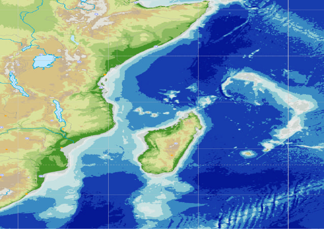
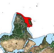
FIGURE A:
MAP OF THE ASCLMES REGION SHOWING PARTICIPATING COUNTRIES,
CONTINENTAL SHELVES AND HIGH SEAS
3 0 ° 0 ' 0 " E
4 0 ° 0 ' 0 " E
5 0 ° 0 ' 0 " E
6 0 ° 0 ' 0 " E
L a k e T a n a
1 0 °
D j i b o u t i
1 0 °
0 ' 0 "
1 0 N
0 ' 0 "
N
A d d i s A b a b a
N
S O
S
S D
D
E T
S O M A L I L M E
L a k e T u r k a n a
M o g a d i s h u
L a k e A l b e r t
U
U G
0 ° 0 '
0 ° 0 '
0 "
E
E q
q u
u a
a tt o
o r
K
K E
E
0 "
K a m p a l a
L a k e V i c t o r i a
N a i r o b i
K i g a l i
C D
B u j u m b u r a
V i c t o r i a
M o m b a s a
S E Y C H E L L E S
L a k e T a n g a n y i k a
D a r e s S a l a a m
T Z
I n d i a n O c e a n
K E N Y A
C O M O R E S
1 0 °
1 0 °
0 ' 0 "
0 ' 0 "
S
1 0 S
S
M o r o n i
L a k e N y a s a
Z
Z M
M
6 0
E
M W
L i l o n g w e
L u s a k a
T A N Z A N I A
M Z
M A U R I T I U S
H a r a r e
2 0 °
Z
Z W
W
2 0 °
M A D A G A S C A R
0 '0 "
M
M G
A n t a n a n a r i v o
0 ' 0 "
S
2 0 S
S
P o r t L o u i s
M O Z A M B I Q U E
4 0
B
B W
W
E
T r o p i c o f C a p r i c o r n
F R A N C E
P r e t o r i a
M a p u t o
M b a b n e
Z A
5 0
S O U T H A F R I C A
3 0 °
E
3 0 °
0 ' 0 "
0 ' 0 "
S
S
D u r b a n
3 0 S
A G U L H A S
L M E
3 0
E
3 0 ° 0 ' 0 " E
4 0 ° 0 ' 0 " E
5 0 ° 0 ' 0 " E
6 0 ° 0 ' 0 " E
AGULHAS CURRENT LME
SOMALI CURRENT LME
FIGURE B: MAP OF AFRICA AND INDIAN OCEAN SHOWING POSITIONS OF AGULHAS
CURRENT AND SOMALI CURRENT LMES (IN RED)
5
8.
The prevailing wind regimes can be divided into two distinct systems: the monsoon regime that dominates
the Somali Current LME), and the subtropical high-pressure system that dominates the southern part (the Agulhas
Current LME). The Northeast Monsoon affects the climate of the northern Indian Ocean from December to April
and is characterized by northeasterly winds over the tropics and northern subtropics. The Northeast Monsoon has
winds of moderate strength, with dry terrestrially derived air and the wind direction tends to be from Arabia to
Madagascar. In contrast, during the months of June to October, the Southwest Monsoon reverses the wind direction
and the winds then tend to be much stronger, with an intense wind jet developing along the high east African
mountains. However, strong winds blow steadily over the entire western Indian Ocean north of the equator. During
the summer disturbances in air pressure and wind movement frequently create cyclones. These cyclones can
intensify to become hurricanes that move in a westerly direction. Those that make landfall generally do so over
Mauritius, Madagascar or Mozambique and can cause extensive wind damage and flooding, with an attendant loss
of life. The subtropical part of the region to the south is dominated by the normal high-pressure system prevalent in
these latitudes. The pressure differences prevailing in the region cause the Trade Winds that are geographically
uniform over the western Indian Ocean, but stronger than those prevailing in other oceans. The wind patterns in the
Indian Ocean are primarily influenced by its geography and, in particular its proximity to two large continental
masses.
9.
The Agulhas Current is the western boundary current of the South Indian Ocean and flows down the east
coast of Africa from 27°S to 40°S8. The source water for the current derives from he Mozambique Channel eddies9
and the East Madagascar Current with the greatest source of water arriving through re-circulation of the southwest
Indian Ocean sub-gyre10. The movement and direction of the current varie s both seasonally and geographically
across its extent. Generally, it is limited to the top 2,300m of the ocean11 but this depth limit increases with
increasing latitude and there is a further seasonal variation causing oscillation in sea surface height within the
current. The main variability within the Agulhas Current are the large, solitary meanders (natal pulses)12 which
occur about 6 times per year. These then spawn an Agulhas ring that subsequently moves into the South-East
Atlantic Ocean. The warm-water link between the Indian and South Atlantic Oceans is likely to have a strong
influence on global climate.
10.
The Somali Current, the western boundary current of the northwest Indian Ocean, reverses direction with
season. During the Northeast Monsoon, the Somali Current flows south and meets the north flowing coastal
Zanzibar Current (which derives from the South Equatorial Current). With the transition from Northeast to
Southwest monsoons , an intense Indian Equatorial Jet (EJ) develops within these waters. The behaviour and effect
of this jet is still not well known, however studies show that the jet generally appears between April and June for
short (one-month) periods. The jet may result in a physical forcing although its influence on productivity is still not
well understood. The Zanzibar Current's geographical extent is seasonally determined so that its interaction with
the Somali Current shifts southward as the Monsoon progresses14. During the Southwest Monsoon the Zanzibar
Current strengthens causing the Somali Current to change direction and flow northward as an intense coastal jet that
may reach velocities of 3.5 meters per second. The flow trajectory along the coastline is complex and a strong
upwelling cell develops as a result. Two coastal upwelling gyres also develop which combine as the monsoon
intensifies. By the time the Southwest Monsoon peaks in August the Somali Current is established as a continuous
current running from the Zanzibar Current (south) to the East Arabian Current (north). Nutrients and primary
8 Gordon, 1985
9 de Ruijter et al., 2002
10 Gordon, 1985; Stramma and Lutjeharms, 1997
11 Donohue et al., 2000
12 Bryden et al., 2003, Lutjeharms et al., 2003, Van Leeuwen et al., 2000
13 An interesting aspect of the Agulhas Retroflection is that it periodically sheds pinched-off anticyclonic rings 320 km. in
diameter at its westernmost extension. These rings enclose pools of relatively warm and saline Indian Ocean water whose
temperature is more than 5°C warmer and salinity 0.3 psu greater than South Atlantic surface water of similar density (Gordon,
1985). The rings keep their distinctive thermal characteristics as far west as 5°E and as far south as 46°S, and they drift into the
South Atlantic at approximately 12 cm s -1 (Lutjeharms and van Ballegooyen, 1988).
14 The surface waters of the Zanzibar Current are prevented by the Monsoon from moving northward during this season; at
depth however, the current continues as an undercurrent below the Somali Current.
6
productivity in the surface waters are generally low, although this is seasonal with higher values being associated
with surface waters in the upwelling areas.
11.
However, new studies and research2 are replacing the traditional view (inter-seasonal and inter-annual
climate variability in the Agulhas and Somali Current LMEs (ASCLMEs) region, and particularly the cycle of
seasonally reversing monsoon winds) with a more complex picture of long-term air-sea interactions and ocean-
atmosphere dynamics. One of the most notable forcing agents behind these climatological and oceanographic
boundary changes is the Mascarene Plateau which interrupts the westward flow of the South Equatorial Current and
consequently determines the fluxes of water, nutrients and biogeochemical constituents the essential controls on
ocean and shallow-sea productivity and ecosystem health. The Plateau extends in range some 2,000 km from the
Seychelles in the north to Reunion in the south and covers an area of approximately 115,000 km2 with water depths
ranging from 8-150 metres. At its edge it plunges some 4,000 metres to the abyssal plain. Recent data from the
Mascarene Plateau15 indicate support for the theory that an open-ocean upwelling system is associated with this
area. Further evidence16 shows that the flow of the South Equatorial Current delivers high levels of nutrients to the
waters of the central and northern Plateau regions, which may be responsible for higher levels of productivity in
these areas all the way up the food chain. There is growing evidence that the Mascarene Plateau area may represent
a separate LME in its own right.
12.
There is limited information available on the wider chemical oceanography of the ASCLMEs region. The
area is considered to be very oligotrophic and characterised by low nutrient concentration, low phytoplankton
biomass and a predominance of regenerated production. Ammonium is found to be the major nitrogen substrate
supplying between 50-99% of the phytoplankton nitrogen requirements. Nutrient levels do vary seasonally,
especially between the monsoons. The Indian Ocean generally is subject to large variations in salinity as a result of
drastic changes in rainfall both seasonally and from year to year (again, associated with the monsoons). Sea surface
salinity is affected by rainfall, but is also affected by anomalous anticyclonic winds blowing in the southeast Indian
Ocean block the transport of saltier water out of the western Indian Ocean. Winds in the region are seen to effect
salinity and rainfall both of which are linked to El Nino events.
13.
Annex 2 provides a summary of the present day oceanographic knowledge within the ASCLMEs region.
Maps depicting the surface currents of the ASCLMEs appear below in Annex 7.
BACKGROUND BIOLOGICAL CONTEXT
14.
The region's mangroves, seagrass beds and coral reefs reflect a high degree of biodiversity and endemism
and, along with beaches and estuaries, serve as a home, breeding ground and/or nursery areas for many species (see
www.edc.uri.edu/lme for references). Ocean currents in the area disperse the larvae of fish and crustaceans from
spawning areas to other habitats, and thus play an important role in recruitment. The exact dispersal mechanisms
and range of species remain poorly known, and associated ecological and physical processes need to be studied.
However, the inshore current is thought to play an important role in larvae dispersal in the Somali Current LME,
along the coastlines of Kenya and Tanzania, while in the Agulhas Current LME, the South Madagascar upwelling is
thought to supply recruits for parts of the Mozambique Channel (Lutjeharms, 2004). The Angoche upwelling, off
the coast of Mozambique is thought to be similarly important in this regard (ibid). This also holds true for coral
dispersion where it is now generally accepted that one reef system can provide the spawning recruitment for
another reef system some hundreds of miles down-current. A better understanding of these processes is needed in
order to identify priority areas for conservation endeavours, while improving the ability to adapt fisheries
management in the face of environmental variability. Several studies have indicated that the Agulhas Current is
responsible for the dispersal of the early life history stages of various fish species. Both the ACLME and the
2 Spencer et al 2005
15 Gallienne, C.P. and D. Smythe-Wright, 2005
16 New et al, 2005
17 Tomczak, Matthias & J Stuart Godfrey: Regional Oceanography: an Introduction 2nd edn (2003)
18 Abbreviations include those for the East Arabian Current (EAC); South Java Current (SJC); Zanzibar Current (ZC). Other
abbreviations denote Fronts and include the Subtropical Front (STF); Antarctic Polar Front (PF) and the Weddell Gyre
Boundary (WGB)18.
7
SCLME are Class II, moderately productive ecosystems (150-300gC/m2-yr) based on SeaWiFS global primary
productivity estimates. Little is documented on seasonal fluctuations in zooplankton within these LMEs.
15.
Over 11,000 marine fauna are currently recorded from the western Indian Ocean region (island states
included). The species inventory is however incomplete, and there are large gaps in the data set. Existing data are
based largely on fragmented shallowwater surveys. The benthic invertebrates of deeper waters, especially those of
the continental slope and abyssal zone, remain virtually unexplored19. Beyond the thirty meter gradient little is
known about species diversity and population densities, and within the thirty meter gradient much remains to be
described. According to some projections, less than 50% of the marine species actually present have been described
and that, at existing rates of description, it will take 200 years to fully describe the remaining fauna (Griffiths,
Indian J, Mar. Sc i. In press). The region has a high diversity of marine life20, from phytoplankton and zooplankton
that drive the fisheries, through several thousand species of larger invertebrates and fish of which many (such as
tuna, lobster, shrimp, oysters, clams, etc.) are of economic significance, to charismatic species such as the
Coelacanth, dugong, turtles and many species of cetaceans. There are also important seabird populations,
particularly on the offshore islands.
16.
Seagrass beds, coral reefs and mangrove forests provide important critical habitats of high diversity within
the ASCLMEs. Of the 50 globally described seagrass species, 13 are found in the Mascarene Plateau area22.
Preliminary data from the Shoals of Capricorn Marine Programme indicate very large, previously uncharted,
seagrass beds in the Mascarene Plateau (Burnett et al. 2001). Coral reefs are founds throughout the area providing
important habitat for fish, invertebrates and lower organisms. These include fringing and patch reefs along the coast
and offshore islands, although these are broken around river outlets. The region is characterized by high endemism
amongst the coral fauna. The total predicted number of coral species in the western Indian Ocean is over 370
(UNEP-WCMC). Coral reef status has been assessed along the coastline of East Africa23 and throughout the Indian
Ocean Island States24. Coastal reefs cover an area in total of just under 7,000 km2. Mangrove forests are found
mainly in nutrient rich river estuaries, including the estuaries of the Limpopo, Zambezi and Rufiji and Tana Rivers.
These habitats are critical fish spawning and nursery areas, and provide other vital ecological services, such as
shoreline shelter from ocean swells.
17.
Seamounts may be rare within the ASCLMEs or around the Mascarene Plateau, but so little is known
regarding the bathymetry and topography of certain areas within the region (especially the Mascarene Plateau) that
lack of knowledge of the presence of seamounts may be a reflection of the general lack of knowledge for this area.
BACKGROUND SOCIO ECONOMIC CONCERNS
18.
160 million people reside in countries bordering the ASCLMEs area while the overall coastal population in
the region (including the islands) is estimated at some 55 million. The region is characterised by some of the
highest poverty levels in the world. This population is greatly influenced by environmental phenomena linked to the
Indian Ocean. Most nations in the area place great reliance on the sea to assure food security through the harvest of
living marine resources for subsistence and employment including from artisanal fisheries, transport and coastal
tourism industries.
19 Ibid
20 Ibid
21 Western Indian Ocean Environment Outlook, Global Environment Outlook 2000, UNEP.
22 Ibid
23 Obura et al, 2005
24 Ahamada et al, 2005
25 Obura et al, 2005
26 Ahamada et al, 2005
27 Turner, J. and R. Klaus, 2005.
28 The Royal Society. 2005.
8
19.
The Agulhas and Somalis Current LMEs support regionally important fisheries, with industrial fishery
landings of approximately 280,000 metric tones per annum (FAO 2002) 29. The main industrial fisheries include the
tuna fisheries, and smaller fisheries for orange roughy, squid, lobster and prawns. The fishing industry provides a
significant contribution of foreign exchange to the region. Fisheries exports of US$943 million significantly
surpassed imports of US$227 million in 2002. Catches by vessels of non-African states represent about 25 to 30
percent of fish catch. Commercial fishing for shrimp and for pelagic species such as tuna have secondary effects in
their impact on other species such as cetaceans and turtles, while processing factories and port developments have
an impact on the coastal zone in terms of pollution, habitat destruction and the concentration of people. Meanwhile,
data suggests fishing effort is escalating, especially by distant fishing nations operating in international waters.
Inevitably this expanding fishing effort will focus on the upwellings and higher nutrient and productivity areas
associated with the Agulhas and Somali Current LMEs and the Mascarene Plateau. However, most of the region's
fisheries go unreported in global statistics, largely due to their unregulated and informal nature.
20.
Fish often represent the primary source of animal protein for many local communities in the region.
Nutritionally, fish are an important source of protein, especially where other sources of animal protein are scarce or
expensive. This is particularly the case in the Small Island Developing States (SIDS). The share of fish to animal
protein exceeds 50% in Seychelles and Comoros and is greater than 20% in all countries except Kenya, South
Africa and Madagascar. Rice, maize, wheat and cassava make up the bulk of the food consumed by the people of
the region. However there are essential micro-nutrients not found in these staples or found only in small quantities,
for example iron, iodine, zinc, calcium, and vitamin A. Symptoms of these deficiencies in the region include goitre.
Fish are particularly rich in these micronutrients, for example iodine, and also contribute fatty acids necessary for
the development of the brain and body. The importance of fish in the diet of a population is therefore now widely
recognized, especially for the diets of young children, infants and pregnant women. Further, fish harvesting,
processing and marketing generates livelihoods, employment and income for approximately 2.2 million people
along the coast of the ASCLMEs. Although employment cannot be taken as a firm assurance of food security,
artisanal fisheries exist in coastal areas where alternative employment opportunities are scarce. The sector thus
makes a key contribution to household welfare (including both subsistence and income generation).
21.
Artisanal and subsistence fishers take a much wider range of fish and invertebrates than do
industrial/commercial fisheries. This is because small-scale fishers of the region are resourceful in developing
different fishing techniques to take advantage of every possible niche available for harvesting. More than 100
artisanal fishery types have been identified and described for the region which range from passive trap fishing to
labour-intensive seine netting and spear fishing32. The IOTC estimate that artisanal fishermen now take as many of
the 16 tuna species in the Indian Ocean as a whole as do the industrial fleets. This may serve to highlight the
significance of the need for a clear definition between artisanal and subsistence fishermen. Artisanal fishing, which
generally requires low financial capital inputs, often constitutes the basis of a diversified livelihood strategy for
coastal communities. It can help to i) spread risks between various economic activ ities in an uncertain environment
and therefore reduce vulnerability, ii) create a synergy with other livelihoods and enhance capital accumulation, and
iii) generate cash. Fishing, even as a secondary activity is therefore important for the generation of income for
coastal communities along a large swathe of the region's coastline. Most of the region's 236,000 fishers use low
technology gear (harpoons, hand lines, traps, seines and nets) that take a diverse catch of fish and invertebrates,
including, at times, other marine animals (e.g. turtles). One of the main social concerns relating to artisanal fisheries
29 This estimate does not take to account takings from distant water fishing fleets in international waters and does not take full
account of artisanal fisheries. According to other estimates, the total catch including subsistence, artisanal and industrial
landings, and takings by distant water fishing nations in international waters, approaches 4 million metric tones29 per year (Van
der Elst, 2004).
30 These rates of growth contrast with growth in urban centers which is particularly high, and the total resident population in
these areas is expected to double in about 25 years. Mombassa, Dar es Salaam, and Maputo are for instance, registering growth
rates of 5.0%, 6.7% and 7.2% per annum respectively.
31 This estimate does not take to account takings from distant water fishing fleets in international waters and does not take full
account of artisanal fisheries. According to other estimates, the total catch including subsistence, artisanal and industrial
landings, and takings by distant water fishing nations in international waters, approaches 4 million metric tones31 per year (Van
der Elst, 2004).
32 Western Indian Ocean Environment Outlook. 2000
9
is the need to improve the social and economic situation of traditional fishing communities. There is considerable
evidence that such communit ies are amongst the poorest segments of society in the region. This situation is getting
worse as the number of artisanal fishermen increase as a reflection of the lack of alternatives within the local
economies.
22.
The problem of poverty has been aggravated by recent drought situations that have hit parts of the region in
recent years, manifested in recurring food crises. Poverty and food security are linked concepts. People who are
chronically poor usually lack access to food. Additionally, malnutrition negatively affects people's working and
learning capacity, and may affect vulnerable groups living just above the poverty threshold, causing them to enter
the ranks of the poor. Poverty in the region is particularly acute among vulnerable groups such as households
headed by the elderly and children (that are now on the increase due to the impact of the HIV/AIDS pandemic).
Fisheries workers are a group highly vulnerable to HIV/AIDS, often as a result of the migrant nature of their work.
Increased understanding of the nature of the fisheries in the region, in particular near-shore fisheries will serve to
enhance their management. This will ensure that fish remains an important food source for coastal communities
over the long-term horizon. This is especially important on the African coastline where HIV/AIDS infection rates
can be as high as 20-25% and where the compound effects of morbidity from the illness and malnutrition (i.e. from
food crises) is leading to high mortality amongst vulnerable groups.
BACKGROUND - POLICY AND INSTITUTIONAL CONTEXT
International, regional and national policy frameworks
23.
Environmental management activities in the region are aligned with a number of global and regional policy
frameworks. Table 2 summarizes the key policy frameworks pertaining to the ASCLMEs region.
TABLE 2:
AGULHAS & SOMALI CURRENT LMES COUNTRY PROFILES
INTERNATIONAL AGREEMENTS
Convention / membership
Somalia
Kenya
Tanzania
Mozambique
South Africa
Madagascar
Comoros
Seychelles
Mauritius
France
EU
UNCLOS III (1982)
X
X
X
X
X
X
X
X
X
X
X
Nairobi (UNEP)
X
X
X
X
X
X
X
X
X
X
Soon
FAO Code declaration
X
X
X
X
X
X
X
No
X
X
X
Straddling stocks
No
No No No
X
No No
X
No
X
X
SWIOFC
X
X
X
X
X
COI BLOCK OF
X
`TUNA COUNTRIES'
X
IOTC
No
No No No
No
X
No
X
X
X
WIOTOC
No
No No
X
No
X
X
X
COI
No
No No No
No
X
X
X
X
X
X
10
Convention / membership
Somalia
Kenya
Tanzania
Mozambique
South Africa
Madagascar
Comoros
Seychelles
Mauritius
France
EU
EAC
No
X
X
No
No No No
X
No
No
No
SADC
No
No
X
X
X
No No
X
No
No
Soon
24.
Table 3 describes the regional institutions established to give effect to these frameworks.
TABLE 3:
INSTITUTIONAL CONTEXT - REGIONAL INSTITUTIONS
Institutions
Member Countries
Function/Mandate
The Nairobi
All participating countries of the project
To protect and manage the marine environment and coastal
Convention
areas of the Eastern African region.
New
All participating countries of the project
Development of a common and integrated regional platform
Partnership
for the management of marine and coastal resources as a
for African
model in Africa. Establishment of an Africa environmental
Develop.
resource centre under consideration.
(NEPAD)
South African Mozambique, South Africa, Seychelles,
Marine Fisheries and Resources Programme aims at the
Dev.
Tanzania
development of marine fisheries in the SADC region. SADC
Community
supports a fisheries monitoring Programme in several member
(SADC)
countries.
Indian Ocean
Comoros, Madagascar, Mauritius,
Improve living standards in the participating countries.
Commission
Seychelles
Promote cooperation in diplomacy, economy, trade,
(IOC)
agriculture, fishing, and the conservation of resources and
ecosystems.
Indian Ocean
Australia, China, Comoros, Eritrea,
The IOTC is an intergovernmental organization mandated to
Tuna
European Community, France, India,
manage tuna and tuna-like species in the Indian Ocean and
Commission
Islamic Republic of Iran, Japan, Kenya,
adjacent seas. Its objective is to promote cooperation among
(IOTC)
Republic of Korea, Sultanate of Oman ,
its Members with a view to ensuring, through appropriate
Madagascar, Malaysia, Mauritius, Pakistan, management, the conservation and optimum utilization of
Philippines, Seychelles, Sri Lanka, Sudan,
stocks.
Thailand, United Kingdom and Vanuatu.
Southwest
Commission recently formed. Mandate
Functions proposed include measures intended to: Ensure
Indian Ocean
developed and agreed upon. First meeting
long-term conservation of fisheries resources through
Fisheries
held and operations recently begun.
application of an ecosystem approach; prevent or eliminate
Commission
Steering Committee comprised of
over-fishing and excess fishing capacity; apply a
(SWIOFC)
Seychelles, France, E.C., Australia and
precautionary approach consistent with the FAO Code of
New Zealand. Membership is open to any
Conduct and the 1995 Agreement; maintain fish stocks at
country within or bordering the SWIO,
levels that are capable of producing maximum sustainable
from Somalia to South Africa.
yield, and rebuild stocks to those levels; ensure that fisheries
practices and management approaches take due account of
need to minimize harmful impact on the marine environment;
protection of biodiversity; and give full recognition to the
special requirements of developing States.
25.
Much work needs to be done to introduce ecosystem-based assessment and management to ASCLMEs
countries. The policy framework for national ecosystem management is generally insufficient: all eight countries
have national environmental plans and most countries have fisheries master plans; however, the international
coordination of these plans through the participation of all stakeholders in the transboundary diagnostic analysis
(TDA) and the strategic action plan (SAP) processes for these adjoining large marine ecosystems has not yet been
undertaken. Several countries have instituted near-shore governance mechanisms or institutional structures to
11
manage marine and coastal resources, but these have yet to be harmonized in international agreements regarding
standardization of ecosystems condition assessment indicators, and the prioritisation of agreed upon actions on
which success depends. Some likely plans are embedded in integrated coastal zone management initiatives.
Common policies and actions under development or adopted by countries throughout the region include:
· National Fisheries Management Strategies to promote sustainable and responsible fisheries development,
optimisation of sector benefits, development of fisheries-related MPAs, resolution of conflicts within and
between artisanal and commercial fisheries, and improved monitoring and data collection to underpin the
management of commercial fishing operations.
· Development of integrated ecosystem conservation and management approaches through management of
coastal pollution, expanding the network of MPs, monitoring and control of coastal development, general
monitoring of the coastal environment (including coral reefs and ecotoxicology)
· Promoting the involvement of coastal communities in a fair and equitable manner to achieve socially and
economically sustainable resource exploitation and management.
· Promotion of sustainable development and economic recovery plans linked to the protection and
maintenance of ecosystem functions.
26.
Specific relevant policies in the participating countries are summarised in Annex 3.
THREATS TO THE LMES
27.
Human induced pressures on the ASCLMEs are increasing at an accelerating pace. There are four primary
threats to the ecological integrity of the ASCLMEs, namely:
· Human induced habitat destruction and alteration of the marine environment;
· Pollution of the marine environment;
· Overexploitation of fisheries resources; and
· High by-catch and incidental mortality of marine fauna in commercial fisheries operations; and adverse
consequences related to anthropogenic related environmental variability within LMEs.
Table 4 provides a more detailed description of these threats.
TABLE 4:
DESCRIPTION OF THREATS TO THE ASCLMEs
Threat
Description
Human induced
Habitat destruction is manifest in the degradation of seagrass, loss of mangroves and damage
habitat destruction
to coral reefs. The severity of habitat disturbance varies throughout the region, with `hotspots'
and alteration of the
concentrated in areas with high population densities and rates of population increase.
marine environment
Problems are particularly acute around urban and suburban centres . Mangroves are being
cleared for mariculture or for salt production. Coral reefs are being mined in certain areas for
lime and for construction materials, as well as for the curio trade. In several areas, coral reefs
are also being damaged by the use of explosives for dynamite fishing, despite this practice
generally being banned.
Pollution of the
Point and non-point land based pollution of coastal areas in the WIO is a growing problem.
marine environment
Large quantities of fertilizer and pesticides used in agricultural areas gradually make their
way to the sea as runoff. Siltation has increased each year as a result of human activities on
land such as mining, clearing for agriculture, industry, urban growth and dredging, and this is
changing the coastal configurations of river deltas. Mining of titanium and zirconium, and
mining-related activities in general, have adverse down stream impacts and disturb sand dune
systems, wetlands and estuaries. Marine-based sources of pollution stem from the exploitation
of the seabed for oil, minerals, sand and corals. Shipping around Cape Agulhas in South
Africa, is exposed to extremes of weather conditions, which greatly increases the risk of
major marine pollution incidents, particularly from oil tankers. Ship spills, ballast discharges,
bilge washings, offshore oil exploration, and refinery effluents cause oil pollution. This type
of pollution is particularly prevalent in the Somali Current LME because it includes major
tanker routes carrying oil produced in the Persian Gulf to markets.
12
Threat
Description
Pollution from land based and marine sources is often localized, and currents play a major
role in transporting pollutants from distant sources. The inshore circulation within the
SCLME provides conveyance for the transport of pollutants on the Kenya/ Tanzania coasts,
including heavy metals and POPS from industrial centres in the region. In the ACLME,
coastal currents running along the shoreline from Maputo in Mozambique through Kwa Zulu
Natal in South Africa receive considerable urban and industrial runoff, and pollutants
discharged by rivers. These currents are influenced by upwelling cells, which in turn have
bearing on pollution transport to areas downstream.
Overexploitation of
Generally artisanal fisheries are considered to be fully or over-exploited in the region,
fisheries resources;
especially near centres of population. There are now few, if any underexploited nearshore
and unnecessarily
areas in the ASCLMEs 33. Fishing intensities have increased dramatically over the past two
high by-catch and
decades, as a result of population increase along the coastal fringe. Known demersal and
incidental mortality
semi -pelagic (non-tuna) resources are generally heavily-exploited inshore and less-exploited
of marine fauna in
offshore, although information on the pressures placed by distant fleet fisheries on the
commercial fisheries
resource is still largely incomplete. Limited potential for increased catches exist except for
operations
Madagascar, Mozambique and Somalia where potential for increasing catches of some
species may be significant. However, reported catches for Madagascar and Mozambique may
actually be underestimates because of the difficulty of estimating artisanal catches over their
long coastlines. Prawn fisheries have artisanal as well as industrial sub-sectors. The industrial
sub-sectors account for significant export revenue and are limited-access fisheries managed to
optimise economic return. Coastal prawn resources are heavily exploited.
There is a significant by-catch problem in the ASCLMEs. While actual by-catch tonnage is
impossible to quantify (about one-third of reported catch is not identified by species and
illegal, unreported and under-reported catch would significantly increase by-catch tonnage)
information on by-catch from the shrimp fishery is telling. The Trawl fisheries for shrimps in
tropical and subtropical regions generate by-catch of up to 70 % of total catch, since this catch
is of lower value than the target species it is normally discarded at sea.
Adverse
Human forced climate change in the region is increasing environmental variability, with
consequences related
ramifications for weather, fisheries and biodiversity. Oceanographic effects from climate
to anthropogenic
change such as elevated water temperatures and changes in storm frequency have contributed
related
to increased variability in catch and species composition. Increases in sea surface
environmental
temperatures have had a severe impact on coral fauna, with episodic coral bleaching events
variability within
tied to El Nińo Southern Oscillation phenomena. The incidence of coral mortality following
LMEs
such events has increased dramatically. The coral bleaching events of 1998 reduced hard coral
cover throughout much of the ASCLMEs area by between 30-95%. So far, the reefs of the
Mascarenes have escaped mass mortality from bleaching, which now increases their
conservation significance within the wider Indian Ocean where such mortalities have been
widespread, and close to catastrophic in some areas. It is predicted that if management doesn't
improve and there are repeated climate-related stresses (which are seen to be inevitable) then
most of the reefs in the region will have less than 20% cover by 2014.Furthermore,
acidification of the oceans as a result of increased carbon dioxide levels is another serious
concern. Ocean acidification is essentially irreversible during our lifetimes. The impacts of
ocean acidification on marine organisms and their ecosystems are much less certain.
However, there is convincing evidence to suggest that acidification will affect the process of
calcification, by which animals such as corals and molluscs make shells and plates from
calcium carbonate. The tropical and subtropical corals are expected to be among the worst
affected, with implications for the stability and longevity of the reefs that they build and the
organisms that depend on them. Other calcifying organisms that may be affected are
components of the phytoplankton and the zooplankton, and are a major food source for fish
33 Some minor areas of the coast of Mozambique and Madagascar excepted. For example, along an isolated stretch of coast
between Inhambane (city) and Villanculos.
13
Threat
Description
and other animals. Many low-lying coastal areas are extremely vulnerable to sea level rises
associated with climate change. This is likely to cause losses in productive coastal lands and
threaten wetlands and other coastal habitats. An increase in the frequency and intensity of
extreme weather events associated with climate change, including cyclones and droughts is
also expected. The degree of environmental variability caused by climate change is expected
to be conditioned by ocean-atmosphere links, which remain poorly understood in the region.
This is compromising the ability to plan adaptive measures.
28.
The NOAA LME site carries background information on each of the World's LMEs for each of the LME
modules. The module on Ecosystem health and Pollution ranks the Somali Current LME as severely impacted in
the areas of habitat and community modification, and fisheries. The same Module for the Agulhas Current LME
lists it as being severely impacted through unsustainable exploitation of fisheries, i.e. overexploitation, excessive
non-target species by-catch and discards, and destructive fishing (i.e. use of fine-mesh nets).
29.
Although the GIWA process has yet to finalise its assessment of either the Agulhas Current or the Somali
Current LMEs, it has reported on the assessment of the Indian Ocean Islands and the vast expanse of ocean between
them. The most important transboundary concern identified by GIWA for that area is pollution as in (i) pollution of
groundwater, surface water, and wetlands; (ii) risks for human health; (iii) degradation of coastal marine
environments (including coral reefs) and tourist attractions such as beaches; (iv) possible disease outbreaks and the
destruction of fisheries; (vii) accumulation and toxic effects of leachates; and (viii) eventually impact on the
economy.
30.
The aforementioned threats have determinants that may be separated into ultimate and intermediate root
causes. Ultimate root causes include population increases especially in coastal areas, poverty (four of the
participating countries rank among the thirty poorest countries in the world), and anthropogenically-induced
climate change. The project is relevant to poverty reduction, and therefore to the amelioration of many of these root
causes. These causes lie beyond the scope of this project. Intermediate root causes are capacity related: notably a
deficit in capacities at the systemic, institutional and individual levels to manage the ecosystem. The root causes are
elaborated in Annex 4. The basic lack of understanding of key LME processes is a major constraint in advancing
joint management endeavours. The intermediate root causes are further elaborated in the following analysis of the
baseline.
BASELINE ANALYSIS
31.
The business-as-usual course of events prevailing over the next 5 years in the absence of GEF intervention,
includes the activities of government ministries and institutes and donor activities aimed at managing marine
resources at largely national level. These interventions make an important contribution towards the management of
coastal and marine resources in the ASCLMEs region, and thus provide an important base in which this project is
nested. Table 5 lists the main baseline activities, along with their implementing bodies. Key Programmatic gaps
serving as constraints to LME management are highlighted.
TABLE 5:
PROJECT-RELATED BASELINE ACTIVITIES
Baseline Activity
Organization/Project/
Gaps
Programme
Oceanographic Assessment
Government
Little or no emphasis on transboundary issues. Very
Oceanographic
shallow layer of trained oceanographers and limited
Country EEZ based oceanographic
Institutes or
budgets limit the number of ship cruises and purchase of
research, data and information creation, oceanographic
specialized equipment for non-ship based activities such
collection and storage
departments in
as GIS based modelling. Limited opportunity for extra-
environment or
national training. Data and information is nationally
fisheries ministries
based and not generally shared at regional level. Public
participation generally not emphasized.
14
Baseline Activity
Organization/Project/
Gaps
Programme
Training (Physical and Chemical
University based
With the exception of South Africa, very low enrolments
Oceanography and related Ecology/
oceanographic and
and limited or no oceanographic or marine sciences
Biology disciplines).
marine sciences
Programmes offered in curricula. Retention of university
Training of oceanographers
advanced degree
trained scientists very difficult. Limited ability for
Training marine scientists
Programmes
professional advancement (connected to low retention
rates).
Applied Research
French IRD (THETIS
Entry level is large pelagic fisheries giving limited
Programme ),
breadth to ecosystem based, LME approach. Limited
Marine ecology
ECOMAR, IFREMER
geographic range of interest across the ASCLMEs due to
Bio-indicators
limited membership of project participating countries.
Ecosystem modelling
Country and regional capacity building emphasis limited
Fish inventories
in scope. Data and information not generally available at
Shoals of Capricorn
regional level and more narrowly targeted to tuna and
Project (RGS). Training other large pelagic fish.
Mascarene Plateau
in scientific, practical
Specific focus on Mauritius and Seychelles rather than
and marine safety skills, region as a whole.
in order to support
research
Information Management
Data and information fragmented across institutions. Data
sets are not consistent across the region. There is no
Establishment and maintenance of
regional database.
marine sciences data and information
bases.
Electronic access to four main
UN Atlas of the Oceans Serves as a repository of selected marine based data and
gateways of ocean related information
information. No operational capacity in the WIO.
Integrated Coastal Zone Management
EU
No emphasis on offshore areas as needed to ensure LME
(ICZM)
IOC/COMESA
level management. Data and information will be limited
National activities in
primarily to coastal areas and covering coastal marine
Management of marine biodiversity
Kenya, Madagascar,
resources, as will training and public participation
and natural resources
Mauritius,
initiatives including awareness building.
Awareness activities in the CZ
Mozambique,
Regional Training and Excellence
Seychelles South
Centres
Africa, Tanzania
Negotiating capacity
Pilot CZM projects
Pollution Abatement
Ministries of
Lack of accurate data baselines to measure relative levels
Environment and
of pollution makes much activity reactive in nature. A
Coastal zone and EEZ based pollution
related Departments
shallow layer of trained staff, poor training opportunities,
abatement
and Agencies
and limited budgets make monitoring and enforcement
activity difficult. There is very little interaction among
ministry personnel at the regional level, and
correspondingly, limited sharing of data sets.
Fishery Management (Stock
IOTC
Focus is on tuna stocks and no significant emphasis on
Assessment)
LME approach. Limited representation of participating
Tuna resource assessment and
countries as many are not IOTC members. No near-shore
management including research on and
emphasis. Limited emphasis on country capacity building
monitoring of stocks, tagging, targeted
for LME based investigations. Data and information
to tuna and related, large pelagic
targeted to tuna and related species. Some data and
species
information likely to be proprietary.
Artisanal Fisheries
Jakarta Mandate
No overall emphasis on LME wide science and LME
Improve understanding of small scale
(NORAD and IUCN)
wide management approaches.
fisheries
Address destructive fishing practices
Fisheries Management: Control
SADC MCS
Emphasis limited to fisheries resources. Not all
Improved management of fisheries
Programme (EU)
participating countries are members of the SADC thus
15
Baseline Activity
Organization/Project/
Gaps
Programme
through institutional capacity building
limited geographic scope. Little data and information
in monitoring, control and surveillance
collected.
Environmental Variability
CORDIO-SIDA Project Activities confined to coral reefs and no overall emphasis
Exploration of causes and effects of
on LME based management.
coral bleaching and mass mortality of
corals in seven countries of the WIO
Scattered research on Ocean-
atmosphere links and meteorology of
the Indian Ocean
Information not codified and available to the region
Conservation of Biodiversity
WIO-MPA
Narrow focus on marine and coastal protected areas.
Creation of a participating network of
(WWF/FFEM/CI)
Some capacity building but again targeted to MPA
MPAs
personnel. Capacity building and stakeholder
Creation of a working network of MPA
involvement primarily tied to coastal zone related
managers
management and resource issues.
Awareness Raising
Marine Science for
Restricted to coastal environment and no significant
Increase public awareness on related
Management
emphasis or focus on LME wide management issues or
issues
Programme (SIDA) and the filling of LME wide knowledge gaps.
Plan and conduct targeted research
administered by
activities of national and regional
WIOMSA
importance
Disseminate information and data
Shoals of Capricorn
Project reach limited to Seychelles and Mauritius and
aimed at helping to achieve sustainable
Project (RGS)
limited emphasis on coastal and coral reef based ecology.
use
32.
An earlier version of a TDA was prepared by the UNEP as part of previous PDF-B for the West Indian
Ocean. The TDA was described by the UNEP as very preliminary in nature, and that much remains to be done
before a TDA and SAP that meets GEF standards is in place. Notwithstanding the very preliminary nature of the
existing TDA, the major threats that were identified during the TDA development process are quite similar to those
identified by the ASCLMEs and SWIOFP projects during preparation. The UNEP Preliminary TDA identified the
following list of major perceived problems and issues. It included four existing problems/issues:
a) Shortage and contamination of fresh water;
b) Decline in harvests of marine and coastal living resources;
c) Degradation of coastal habitats (mangroves, seagrass beds, and coral reefs), loss of biodiversity; and
d) Overall water quality decline and contamination of coastal waters, beaches and living resources.
33.
Root causes identified in the UNEP driven preliminary TDA were also similar to those that have been
identified during preparation by the ASCLMEs and SWIOFP projects, and were as follows:
1. Rapid growth in coastal population and urbanization
2. Lack of policies and legal framework
3. Inadequate knowledge
4. Institutional Weakness
5. Lack of management strategies
6. Inadequate financing mechanisms and support, lack of investments
34.
Elements of this preliminary UNEP TDA may be used in the overall TDA as coordinated by UNDP where
appropriate. The GEF is now providing catalytic support to a revision of this preliminary TDA.
Barriers to LME Based Management
35.
Under the Baseline Scenario, numerous, but largely fragmented, efforts will be made to improve
management of the coastal and marine environments of the ASCLMEs. Despite the number of Programmes
underway and planned inter alia in the arenas of fisheries management, pollution control and integrated coastal
zone management, the scale of action is being outpaced by human-induced threats to the coastal and marine
environment. Countries generally lack the absorptive capacities and the financial wherewithal to take these
16
initiatives to scale. A number of regional initiatives are in place, nested in a regional policy framework and growing
consensus on the need to work collaboratively to address the suite of threats facing marine ecosystems and their
constituent resources. However, these focus heavily on the coastal zones of the participating countries.
Accordingly, current and planned initiatives will not by themselves be sufficient to institute an ecosystem approach
to LME management. Given the transboundary nature of many threats, their root causes and effects, the threats to
the environment cannot effectively be contained through national and sectoral initiatives alone, and a holistic multi-
sectoral regional ecosystem management approach is needed. There are several barriers to `mainstreaming' an LME
approach into national and regional management structures and processes which can be listed as follows:
36.
A. Inadequate data for management purposes: Clearly, there is a strong concern regarding inadequate
and insufficient data with which to inform and drive management processes. All of the countries are aware (to a
greater or lesser extent) of the need for reliable information from which they can evolve integrated and sustainable
marine resource management strategies. The countries are also aware of the need to address transboundary issues in
relation to the LMEs and to act decisively, in a cooperative and coordinated manner, in order to better manage and
conserve the high biodiversity and economic value of the associated resources. Furthermore, they are acutely
conscious of the need to address the significant gaps in knowledge and in on-going data collection and monitoring
that is necessary in order to both develop an effective baseline for management, and to drive a dynamic and
operational management process. In this respect, it should be noted that the ODINAFRICA project, supported by
KMFRI in Mombasa, Kenya is beginning to serve a facilitative role with regard to data collection and
dissemination as it has begun to:
· Provide Scientists in the Western Indian Ocean Region with bibliographic information;
· Prepare and distribute various data products relevant to marine sciences of the WIO region
· Promote communication between WIO marine scientists and marine scientists globally;
· Publicize marine science of the WIO region and other parts of the world; and
· Provide information equipment, software and training.
The Wildlife Conservation Society (WCS) is also assisting the ASCLMEs project by providing a report on the
Assessment, Synthesis, and Gap Analysis of Existing and Planned Activities in the Coastal Zone of countries of the
Agulhas & Somali Current Large Marine Ecosystems. This will help to indicate both where existing information
may be stored as well as to further refine the needs vis-ŕ-vis missing information.
37.
B. Lack of regionally based monitoring and information systems and coordination: To the limited
extent multi-country assessment Programmes are underway at regional level, there has been little attempt to
aggregate existing data, and little attention has been paid to ensuring the ready accessibility of data by end users to
facilitate joint management efforts. There is a major unmet need, identified during project preparation to repatriate
data that has been gathered over many years in the WIO by foreign fishing fleets and research vessels. Weak
information coordination at regional level reduces the value of the information that has been gathered on ecosystem
status. These factors, coupled with the fact that regional institutions have varying numbers of participating countries
as members, and have fragmented mandates, present the greatest barriers to adoption of an ecosystem approach to
LME management. A data and information workshop convened by the Project showed clearly that existing
Programmes and institutions do not possess cross-cutting information at regional scale or, with the exception of
South Africa, even across a full range of marine issues at national scale. There is at present no regional Programme
or institution with the mandate to create and manage such an integrated and over-arching, regionally based
information system which could be accessed by regional stakeholders. Information systems at both national and
regional scale are fragmented, poorly described, lacking in synthesis, and generally unavailable to managers even at
national scale. What little integrated regional information that there is exists in incompatible formats, is not
centrally stored, not synthesized and thus not readily accessible to decision-makers and stakeholders.
38.
C. Lack of national and regional ecosystem level assessment capacity: A solid understanding of
oceanographic, chemical and ecological processes is necessary to manage LMEs. The understanding of energy flow
and trophic interactions in marine ecosystems in the WIO is poor and connectivity studies are needed to facilitate
management of shared marine resources and systems. Biodiversity patterns and ecosystem processes need to be
recognized, understood, and managed effectively in order to maintain ecosystem integrity and to maintain existing,
and indeed to develop future, fisheries industries. The WIO region has been the focus of a limited number of
17
oceanographic related ecosystem assessment efforts; however system wide understanding is rudimentary.
Assessments are hampered by a lack of dedicated ship's time, lack of coordination of ship cruises to assess priority
knowledge gaps, dearth of trained scientists within the region, and a lack of specialized equipment. Very limited
information is available on larval transport, and on the location of spawning grounds and nursery areas.
39.
Some information is available on the status of artisanal fisheries but this is very limited and frequently out
of date. Its accuracy and reliability may also be questionable as there has never been an effective review and
synthesis of such information for the ASCLMEs region. The baseline is characterised by numerous and fragmented
national efforts to manage their artisanal and subsistence fisheries, often as part of a larger ICZM Programme or
biodiversity management project. However, there is limited pooling of data between countries and the
transboundary dimensions of artisanal fisheries, including information on lifecycle aspects (such as spawning,
larval transport and nursery areas) remain largely unknown. Poor management, inadequate ecological information
and the unknown relationship between resources fluctuations and ocean-atmosphere links present threats to both the
sustainable yield for artisanal and subsistence fisheries, and the ASCLMEs's overall biodiversity. Very few of the
artisanal fisheries in the participating countries are subject to management and in less than 10% is there any linkage
between management and scientific information. There is a general lack of valid up-to-date statistics regarding
employment within the artisanal fishing sector. This is further complicated by the lack of an accepted definition for
what actually constitutes `artisanal' fishing. Furthermore, Artisanal fishing tends, to some extent, to be seasonal
(being affected by adverse weather conditions) and may also be associated with other employment activities such as
farming. This difficulty with collecting reliable information on this sector makes management and monitoring
somewhat difficult. Attempts have been made to encourage and organise traditional fishing communities to manage
their own resources. While this has proven to be easier in geographically well-defined areas such as lakes and
rivers, this is much more difficult and complex along the coast where resources are shared with other stakeholders
such as the industrial fleets. These growing industrial fleets are creating tension with the traditional fishermen by
taking more of the already overexploited coastal resources and destroying the stationary gear used by some
artisanal fishermen. These concerns need to be addressed, to facilitate more comprehensive environmental
assessments and thus to address the knowledge gaps hampering management of the LMEs. It should be noted that
IOC in cooperation with the European Union is developing a Regional Programme for the Sustainable Management
of the Coastal Zones of the Countries in the Indian Ocean. This will be looking at some of the problems of artisanal
and subsistence fisheries within the coastal areas of the ASCLMEs and may well be able to provide more up-to-
date, reliable data on this sector.
40.
A number of workshops have been organized within the past two years in an attempt to document the
information that is currently available. This includes a Workshop sponsored by the Royal Society of London in
January of 2003 entitled "Atmosphere - Ocean - Ecology Dynamics in the Western Indian Ocean"34. In addition, a
comprehensive multi-disciplinary review of existing, oceanographic related literature was undertaken during
project preparation. The review covered 200 publications, including scientific literature and local reports and grey
literature. The review shows clearly that there is a dearth of biophysical information and appropriate empirical data
sets compared to other LMEs elsewhere on the globe. There is considerable asymmetry in data coverage across the
region. For example, the oceanographic data sets for the continental shelves adjacent to the Agulhas Current are
relatively robust. By contrast, no appropriate oceanographic data of any kind has been collected for certain shelves
off Madagascar. Further, a detailed assessment of available hydrographic, remotely sensed and marine biological
34 Presentations and discussions included the following subjects: improving predictions of climatic variability from rainfed
agriculture, development of sustainable approaches to the use of marine resources, and the inter-relationships between physical
oceanography and ocean productivity. A special session was also conducted on the research that has taken place on the Shoals
of Capricorn sponsored by the Royal Society and the Governments of Mauritius and the Seychelles. Research results were
presented on seafloor morphology based on one-nautical mile bathymetric mapping, much of it via satellite. Various factors
that influence the meteorology of the Indian Ocean were identified. In addition to the dominant cycles of the Asian and
Australian Monsoon systems, it was shown that the influence of El Nińo on WIO meteorology is significant, leading to greater
variability and accentuating upwelling in several places. Evidence was presented indicating that land structures, such as the
Himalayan Plateau and the East African Highlands have a profound influence on WIO climate patterns. Combined cyclonic
and anti-cyclonic eddies, together with the Mozambique eddies, play a role in triggering the shedding of Agulhas Rings into
the Atlantic. The importance of circulation patterns around the Mascarene Plateau, as well as the Indonesian "throughflow"
were also seen to strongly influence WIO oceanography.
18
data for the ASCLMEs and adjacent region was conducted during preparation35 and verified through two multi-
stakeholder workshops 36. A number of information gaps have been identified and include a need to:
· Identify components of the offshore circulation that affect shelf regions in the West Indian Ocean and thus
the distribution of marine organisms and the geographic structure of marine ecosystems.
· Help determine the extent to which circulation of the ASCLMEs region plays a critical role in local climate
variability and global climate change.
· Provide information on the water characteristics, water quality indexes, and productivity on the shelf
regions of the ASCLMEs that have the most marked effects on the cross-boundary ecosystems and thus
national and transboundary fish stocks.
· Identify important components of terrestrial run-off that influence coastal ecosystems and their health.
· Identify aspects of the cross-boundary marine ecosystem on the shelves of the West Indian Ocean are most
easily disturbed by, most vulnerable to human interference or climate variability.
41.
Work undertaken for the Indian Ocean Commission (IOC) on Sustainable Management of the Coastal
Zones of the Countries in the Indian Ocean37 has identified a lack of valid, precise and up-to-date information and
statistical data relating to the artisanal and coastal fisheries sector.
42.
No organization is currently responsible for regional level capacity building on behalf of the participating
countries, as the current array of regional organizations either lack full regional membership or have an insufficient
mandate to address regional issues in an ecosystem context. In those isolated instances where there are dedicated
cruises in the region's national and international waters, information gained is often not shared with the countries
and participating countries have generally not received the benefit of ship board training in areas of oceanography
and fisheries. A concerted focus on priority management issues is difficult as countries have a shallow layer of
qualified people. These gaps will need to be addressed through a structured long-term Programme, aimed at
building a cadre of experienced resource managers.
43.
D. Absence of public participation, education and stakeholder involvement schemes: Public
participation, education and stakeholder involvement Programmes are virtually non-existent at regional level. Some
national level public participation and education activities through national and donor-funded projects at regional
level are underway but limited mainly to coastal zone areas. No current institution has the mandate to expand public
participation and related activities to regional level and to strengthen regional level capacity to undertake and
sustain regionally based public participation activities. A key element to building governmental support for a
regional approach to LME management and thus for SAP approval and execution will derive from growing public
support for the approach. Thus the absence of regionally based public participation and education approaches is a
barrier to realization of this obje ctive. The need for a structured stakeholder awareness Programme is now
recognized as a priority by NEPAD.
PART II: STRATEGY
THE ECOSYSTEM APPROACH, LARGE MARINE ECOSYSTEMS
AND TRANSBOUNDARY ASSESSMENTS
44.
The Convention on Biological Diversity defines `Ecosystem' to mean a dynamic complex of plant, animal
and microorganisms communities and their non-living environment interacting as a functional unit. It further
defines the ecosystem approach as a strategy for the integrated management of land, water and living resources that
promotes conservation and sustainable use in an equitable way. It focuses on the essential processes, functions and
interactions among organisms and their environment. It recognises that humans are an integral component of
ecosystems. The Conference of Parties to the Convention has endorsed this description of the ecosystem approach,
35 R. Roman and J.R.E. Lutjeharms, An inventory of environmental data for the West Indian Ocean. University of Cape Town,
2004
36 Minutes of the Paarl Workshop, Paarl, SA, May, 2004; Report of the Workshop Titled Towards a Framework for
Information Sharing Between Programmes and Countries in the WIO Region, Grahamstown, SA, October 2004.
37 Landell Mills Ltd. 2004
19
has recommended the application of its principles, and has agreed that the priority at this time should be on
facilitating implementation of the approach.
45.
The GEF Operational Strategies provide guidance on addressing the need to restore and protect coastal and
marine ecosystems. GEF has recommended (Operational Strategy 8) the use of Large Marine Ecosystems (LMEs)
and their contributing freshwater basins as the geographic area for integrating changes in sectoral economic
activities. Current GEF policy includes stabilising and reversing fisheries depletion within large marine ecosystems
through ecosystem-based approaches.
46.
The WSSD Plan of Implementation also encourage the application (by 2010) of the Ecosystem Approach,
relating it to the development and facilitation of the use of diverse tools for the elimination of destructive fishing
practices, the establishment of marine protected areas, and protection of nursery grounds.
47.
Two processes are used by the GEF to engage decision makers, resource managers, the science community
and other concerned stakeholders within participating countries in the establishment of ecosystem-based priorities
for transboundary issues. These are the Transboundary Diagnostic Analysis (TDA) and the Strategic Action
Programme (SAP). The purpose of the TDA is to scale the relative importance of sources, causes and impacts of
transboundary waters problems and to identify potential preventive and remedial actions. This should be an
objective assessment, based on best available verified scientific and technical information, through full consultation
with all stakeholders and technical experts. The SAP enables cooperating nations to jointly determine what policy,
legal and/or institutional reforms and investments are necessary to address the TDA priorities.
48.
In order for a TDA to be effective in developing a SAP it requires sufficient and accurate data on a
multitude of ecosystem-related parameters and issues. Where insufficient information exists then a GEF project
needs to undertake necessary assessment and data capture in order to fill the strategic gaps required to affect a
TDA. This is particularly pertinent to the ASCLMEs project. There is clearly insufficient data on important
ecosystem elements such as productivity, nutrient distribution and fluxes, water quality parameters, larval transport,
spawning and nursery areas that may require protection and/or management, artisanal fisheries (in relation to catch
effort, sustainability and management needs), and definition of certain critical oceanographic processes that are
driving the Agulhas and Somali Current systems that are the foundation of the LMEs. The Project strategy will be
to capture and synthesise missing information along with existing information (both repatriated, and within the
region) to provide an effective environmental baseline assessment suitably robust to support effective TDA and
SAP processes and inform management.
THE PROGRAMMATIC APPROACH
49.
The project is part of a Programme entitled the Programme for the Agulhas and Somali Current Large
Marine Ecosystems (ASCLMEs) that will systematically institutionalize an ecosystem-based approach to managing
the living resources and environment resources of the ASCLMEs.
50.
This project aims to replicate the highly successful approach used by the Benguela Current LME (BCLME)
project. BENEFIT (the Benguela Environment Fisheries Interaction and Training Programme) is a regional marine
research agency for the three national research institutions of Angola, Namibia and South Africa (three countries of
the BCLME Project). BENEFIT was already active in the region prior to the development of the BCLME Project
and, in fact, was instrumental in designing and lobbying to get that GEF LME project endorsed and approved.
BENEFIT has undertaken much of the requisite scientific data and information necessary for the development of a
TDA, and subsequently helped to focus the SAP, which is now being used for regional management of the
BCLME. In the ASCLMEs Project there is also a need to capture this requisite data and information to drive the
TDA process and to thereby develop the SAP and move the countries closer to LME-based Management
approaches.
51.
The Programme will facilitate development of a long-term strategy to strengthen cooperative management
of the LMEs, based on good science and underpinned by efforts to build capacity at the systemic, institutional and
individual levels. An iterative approach is planned, that progressively strengthens management capacities for
20
regional cooperation in addressing transboundary environmental concerns in the LMEs, builds political will and
leverages financing. The long-term Programme goal cannot be realized immediately, owing to gaps in essential
information, limited absorptive capacities for regional co-management, and the need to build the basis of trust
within the region, and between countries and sectors to effect lasting cooperation. Activities planned under the first
phase will inform the preparation of a Transboundary Diagnostic Analysis (TDA) and Strategic Action Programme
(SAP) for the ACLME and an interim TDA for the SCLME focussing primarily on the southern Zanzibar Current
region. Subsequent phases of intervention will support the implementation of the SAP within the ACLME and will
endeavour to expand the TDA in the SCLME to include the northern region as and when political stability may
allow (following which consideration could be given to development of an overall SAP for the SCLME).
52.
The first phase includes three inter-linked projects, drawing on the services of the three GEF Implementing
Agencies: UNEP, UNDP and the World Bank. UNEP will be addressing land-based sources of pollution and
providing TDA information in that thematic area through its GEF WIO LaB project, while the World Bank will be
addressing offshore fisheries beyond the 150 m depth contour (but including coastal commercial crustaceans) and
providing TDA material through SWIOFP (South West Indian Ocean Fisheries Project). This approach will ensure
a more unified approach to environmental management in the LMEs, drawing on the comparative strengths of each
of the agencies. The three Agencies have worked in close collaboration during the preparatory stages of each
initiative. Measures have been agreed and institutional arrangements designed to ensure all activities are well
integrated, and contribute to the common goal. Annex 5 provides a summary list of the objectives, components and
outputs of the SWIOFP and WIO-LaB projects and Annex 6 shows the linkages between the three projects in
relation to the LME modules.
53.
In order to create a framework for adaptive management, and build capacity necessary to institutionalize an
ecosystem approach to marine resource management, the ASCLMEs Project will begin to codify baseline
information, and fill priority knowledge gaps needed to prepare the TDAs, and subsequently the SAPs. The
ASCLMEs Project will examine the physical, chemical and biological processes, including coastal fisheries, which
drive aspects of the LMEs in geographic areas, where information is lacking to finalize the TDAs and SAPs. This
work will further establish the baselines against which to measure the success of future adaptive management
interventions. It should be noted that the project places what appears to be a disproportionate amount of attention to
the Agulhas Current LME. The reason for this is the difficulty in safely accessing large areas of the Somali LME,
especially near-shore areas, given the continued political instability in Somalia, which occupies approximately two-
thirds of the LME's coastline. While the project will undertake activity in the boundary areas of the two LMEs (e.g.
in the Mascarene Plateau and along the South Equatorial current), and will also undertake assessment work in the
Somali upwelling, more definitive work will have to await the return of conditions that would allow for safe
assessments in the Somali LME region. Nonetheless, the TDA/ SAP processes will endeavour to address as full a
range of issues as possible in both LMEs, and the project will seek to repatriate to the region and collate
information on the Somali Current LME, and use other tools, such as satellite altimetry/ GIS to furnish inputs for
the TDA/ SAP processes.
THE MODULAR ECOSYSTEM-BASED APPROACH TO LME ASSESSMENT AND MANAGEMENT
54.
The Programme adopts the LME Modular Ecosystem-Based Approach (MA) to management38. The
approach will be codified within the SAP, and operationalised during the SAP implementation phase with funds
leveraged from national and international sources. The five modules are listed below in relation to planned project
outputs; the matrix delineates individual project responsibilities for the delivery of each module.
38 A five module strategy is being employed worldwide to provide science-based information for the monitoring, assessment,
and management of LMEs. The modules are focused on LME: (1) productivity, (2) fish and fisheries, (3) pollution and health,
(4) socioeconomics, and (5) governance.
21
TABLE 6:
LINKAGES BETWEEN LME MODULES AND PROJECT RESPONSIBILITIES
Module
Description
Project
Role of ASCLMEs Project
Responsibility
Productivity
Identification of productivity
This will be addressed The ASCLMEs Project through
hotspots, trophic relationships,
under the ASCLMEs
cruises and the purchase of state
temporal variability, riverine and
Project.
of the art measuring devices will
upwelling inputs, toxic tides and algal
map productivity hotspots,
blooms, inter and intra systemic
gather necessary information to
linkages, roles of gyres and eddies,
gauge temporal variability, and
and monsoon and atmospheric
gain understanding of the inter
conditions.
and intra-systemic linkages as
needed to inform management
decisions at regional level.
Fish and Fisheries
Larval transport, trophic relationships, Implementation of the
ASCLMEs Project will
fishery interdependent surveys,
activities will be
contribute information to the
systems functioning and relationship
shared among the
SWIOFP project on the issue of
to fisheries, industrial fisheries and
SWIOFP (industrial
larval transport in key currents.
their relationship to artisanal and
fisheries), ASCLMEs
subsistence fisheries, the impact of
(artisanal and
fisheries on biodiversity, the value of
subsistence fisheries)
non-consumptive use and the
and WIO-LaB
interface with consumptive use, and
projects.
commercial and subsistence landings
and effort.
Pollution and
Identification of anthropogenic
WIO-LaB project with The ASCLMEs Project will
Ecosystem Health
threats, natural perturbation, and the
support from
address issues of pollution
conjunction effects of anthropogenic
ASCLMEs project
through assessment of heavy
threats and natural perturbation that
(Heavy metals and
metal and POPs concentrations
relate to ecosystem health.
POPs).
in key indicator species. It will
also assist WIO-LaB, through
cruises, in assessing pollution
from land-based sources.
Socio-economic
Integrated assessments of human
The ASCLMEs and
The ASCLMEs Project public
Module
forcing at the LME level and
WIO-LaB projects
participation Outcome will
attainment of long-term socio-
both have activities
involve stakeholders in dialogue
economic benefits, tasks that are
that address this
about measures to sustain
integrated into the outcomes and
module, including key livelihoods while sustaining the
activities of each of the projects
elements of the
long-term productivity of marine
within the PA.
TDA/SAP process and resources.
looking at economic
benefits at the
community level.
Governance
Addresses Regional Governance
This module is also
The ASCLMEs Project will
Module
issues including institutional
incorporated across
convene representatives of the
development, regional and national
the range of outcomes projects of the Programme,
level capacity building, stakeholder
and activities of the
governments, regional
participation, and adaptive
three projects,
organizations and other
management strategies.
particularly through
stakeholders as appropriate to
the TDA/SAP process agree on cooperative governance
and associated
systems for management, as part
governance reforms
of the process of finalizing the
emerging from the
SAP.
SAP.
22
PROJECT OBJECTIVE, OUTCOMES AND OUTPUTS/ACTIVITIES
55.
The Programme Goal is "To ensure the long term sustainability of the living resources of the ASCLMEs
through an ecosystem- based approach to management".
56.
The Project Objective is "to undertake an environmental baseline assessment of the Agulhas and Somali
Current Large Marine Ecosystems to fill information gaps needed to improve management decision-making, and to
ascertain the role of external forcing functions (such as the Mascarene Plateau and the Southern Equatorial
Current). This information will be used to develop a TDA and SAP for the Agulhas Current LME, and a TDA for
the southern portion of the Somali Current LME".
57.
In line with achieving this Project Objective , The Overall Project Deliverables are:
· Acquisition of data needed to support an ecosystem-based approach to management of the two
LMEs as well as a better understanding of the external forcing functions and linkages to adjacent
areas of the Western Indian Ocean region
· A full TDA and SAP for the Agulhas Current LME adopted at high levels
· An interim TDA and draft management plan that addresses the southern portion of the Somali
current LME
58.
The Project aims to address the Agulhas and the Somali Current LMEs under one initial assessment process
as A. this is a more cost-effective approach for GEF and B. the two systems are closely interlinked, unlike many
clearly discrete LMEs elsewhere in the world. In fact, the Project also intends to extend the assessment to include
the Mascarene Plateau. There is some existing data and further strong evidence that this plateau to the east of
Madagascar exerts a considerable influence on both LMEs through its effects on the South Equatorial Current (a
primary driver of both the Agulhas and Somali current systems). Oceanographic cruises within the region can be
effectively extended to cover this critically important region without having to commission a separate and more
costly initiative. The information from this assessment and data collection phase will, however, be used to develop
discrete TDAs and eventually SAPs for the ACLME and the SCLME, and possible help to confirm the presence of
a possible Mascarene Plateau LME so as to allow due consideration to be given to initiating a TDA and SAP
process for this area at a later date.
59.
It is recognised that there may be some difficulties in undertaking the baseline assessment within the
northern waters of the Somali Current LME. However, the southern area is accessible and the belief is that work
should start were possible to deliver an interim TDA so that essential management strategies can be developed for
the waters relating to the Zanzibar Current. At a later date it is hoped that the assessment and TDA can be extended
and completed for the northern region and embraced within any existing regional SAP for the southern area of the
LME. This will avoid leaving the southern area of the LME unmanaged for an unknown period, to its inevitable
detriment.
60.
The barriers to `mainstreaming' an LME approach into national and regional management structures (as
identified in the baseline discussion above) and which now drive the development of the project objectives for this
GEF UNDP assistance initiatives can be summarised as:
A. Inadequate data for management purposes
B. Lack of regionally based monitoring and information systems and coordination
C. Lack of national and regional ecosystem level assessment capacity
D. Absence of public participation, education and stakeholder involvement schemes
These four barriers provide the justification for the four Project Outcomes listed below
61.
The Project Objective will be reached through four Outcomes:
Outcome
Key ecosystem assessment and management gaps are filled as necessary to install an ecosystem
1
23
approach to LME management
Decision-making tools are in place, to facilitate the synthesis and application of data for LME
2
management;
Regional agreement is reached on transboundary priorities and their root causes and a suite of
3
governance reforms and investments needed to institute a shared ecosystem-based approach to
managing the LMEs in support of WSSD targets, and foundational capacities are in place for
implementation.
A Comprehensive Public Participation Initiative Enables Stakeholders to Engage in Programme
4
activities.
OUTCOME 1: KEY ECOSYSTEM ASSESSM ENT AND MANAGEMENT GAPS ARE FILLED AS
NECESSARY TO INSTALL AN ECOSYSTEM APPROACH TO LME MANAGEMENT
Total Cost: US$ 18,250,000; Co-Financing: US$ 12,500,000; GEF Request: US$5,750,000
62.
The project will finance a number of environmental assessments to fill critical knowledge gaps within the
ASCLMEs in the arenas of physico-chemical oceanography, productivity and biodiversity. This `work will describe
the inter-relationships between currents, water quality, temperature and other variables in the ASCLMEs.
Biodiversity studies will seek to map food webs and biogeography, contribute to knowledge on bio-indicators, and
genetics, provide information on larval transport related to nearshore fisheries and biodiversity (fish and crustacean
larvae, corals, etc), and map the primary spawning grounds and nursery areas for commercial and threatened marine
resources. This information is needed in order to finalize the TDAs, and enable the countries to set priorities for
intervention under the LME SAPs, in turn needed to operationalise an ecosystem approach to the management of
the LMEs, It will also contribute to a better understanding of the determinants of environmental variability in the
ASCLMEs region. Annex 7 supplies a detailed account and summary of the information gaps that need to be
addressed to facilitate LME management.
63.
Offshore data will be collected using dedicated research ships, through the deployment of equipment placed
on the ocean floor and through the use of drifters and satellites. Eight hundred days of dedicated ships' time will be
secured, and additional ships time will be available through SWIOFP (oceanographic data will be collected during
fishery cruises in order to ensure cost efficiencies)39. Ships will also be deployed and tasked for the purposes of
assisting the WIO-LaB project to accomplish its objectives. Nearshore data needs (particularly in relation to larval
transport, spawning areas and nursery areas) will be addressed through a review of existing data, identification of
critical gaps, and prioritisation of activities to address those gaps for the purposes of informing the TDA process as
well as developing a baseline for longer term monitoring.
64.
The assessments will focus in discrete areas, where information gaps are most acute, and will seek to add to
the body of existing environmental information on the LMEs. Assessment activities will be co-financed by the
Governments of Norway and France and by the South African ACEP (African Coelacanth Ecosystem Programme),
which will dedicate ships time, technical assistance and specialized equipment.
65.
The UNDP ASCLMEs Project will undertake an assessment of the artisanal and subsistence fisheries sector
to complement and complete the work that the World Bank SWIOFP project will be undertaking within the
industrial fisheries sector. The SWIOFP project will limit its activities to beyond the 150 m depth contour and is
dealing primarily with blue water fisheries in the high seas, although it will also look at the commercial aspects of
the crustacean and molluscan fishery for the region. Clearly there are many gaps with regard to coastal fisheries at
the community level, which need to be filled in order to provide a fully regional picture for an ecosystem-based
management approach of fisheries per se. The UNDP ASCLMEs project will attempt to fill these gaps.
39 Principal among the ships to be deployed for ASCLMEs based work are the Dr. Fritjof Nansen, which will be available to
the projects on a cost-shared basis with the Government of Norway and managed by FAO, and the RS Algoa, a South African
government research vessel made available to the projects in conjunction with the Government of South Africa and through the
ongoing, directly related work of the ACEP. Other smaller ships, independently contracted by the ASCLME and SWIOFP, and
where possible their capabilities shared between the two projects to maximize efficiencies, will also be deployed.
24
OUTPUTS/ACTIVITIES
1.1 Prioritised ecosystem assessment and management gaps in ecosystemic processes in key geographic
areas of the ASCLMEs addressed
66.
The project will undertake in-field assessments and data collection in order to address specific knowledge
gaps within discrete oceanic areas of the ASCLMEs as shown in Table 740: The project will further review known
information on specific coastal issues directly related to LME management including larval transport and
identification/mapping of important spawning grounds and nursery areas for commercial species. The project will
also review regional initiatives pertinent to artisanal fishery issues in order to capture information relevant to the
LMEs. This will include work undertaken for the Indian Ocean Commission (IOC) on Sustainable Management of
the Coastal Zones of the Countries in the Indian Ocean41 The IOC initiative in particular will be looking at
improving data and information on the artisanal and subsistence fisheries within the ASCLMEs region. Therefore,
any efforts by the currently proposed UNDP GEF LMEs project should therefore coordinate closely with such an
initiative to avoid duplication but to ensure capturing the necessary information to drive the ecosystem approach
TDA process.
67.
The various strategies and approaches for information capture and analyses will feed two primary purposes
in relation to the project's long-term contribution to LME management - A. It will provide input to the TDA and
SAP processes, and B. It will create the national/regional databases necessary to develop the long-term monitoring
and assessment for LME management purposes.
TABLE 7:
LIST OF DATA GAPS AND PROPOSED ASSESSMENT
METHODOLOGIES
Geographic Area: Somali Upwelling and Penetration of Red Sea water in the ASCLMEs
Data Gaps: Information on environmental variability, upwelling, Assessment Methodology: Cruise of the Nansen to the Somali
productivity and related fisheries. Determine how Red Sea water Upwelling in conjunction with the SWIOFP project. Two
reaches the ASCLMEs to increase understanding of global
cruises foreseen.
thermohaline circulation & inter-ocean water exchange
Geographic Area: Kenya and Tanzania Coasts
Data Gaps: Mapping needed of inshore circulation patterns.
Assessment Methodology: Cruises of the Nansen and smaller
Information needed on larval transport, recruitment,
vessels contracted in partnership with SWIOFP and WIO-LaB.
environmental conditions for fisheries, and pollutant dispersal
Geographic Area: Southwest Indian Ocean shelf regions
Data Gaps: Knowledge of shelf circulation patterns and
Assessment Methodology: Two cruises of the Nansen will be
transport of fish larvae, dispersal of pollutants. Information on
undertaken and work will be jointly undertaken with SWIOFP.
system productivity needed.
Dispersal pollutants work undertaken in cooperation with
WIO-LaB.
Geographic Area: South Equatorial Current
Data Gaps: Information on the circulation patterns of off shore
Assessment Methodology: Two cruises by the Nansen in
currents. Productivity and chemical oceanographic assessments. conjunction with the SWIOFP project.
Geographic Area: The splitting of the southern and northern branch of the East Madagascar Current
Data Gaps: No current information on this area is available.
Assessment Methodology: One cruise by the Nansen in
Knowledge of shelf and coastal circulations, biodiversity,
conjunction with the SWIOFP project.
chemistry and geology virtually non-existent.
Geographic Area: The forcing of the South Madagascar upwelling cell
Data Gaps: Baseline information on coastal circulations,
Assessment Methodology: One cruise by the Nansen in
biodiversity, chemistry and geology.
conjunction with the SWIOFP project.
Geographic Area: Mozambique Channel
Data Gaps: Information needed on the shedding and triggering
Assessment Methodology: Cruises will be undertaken jointly by
40 The information that appears in this Table is a synthesized version of Annex 4??.
41 Landell Mills Ltd. 2004
42 Wells, S. 2005
25
of Mozambique eddies. Information also needed on productivity the ASCLMEs Project, SWIOFP, and the ACEP. The Nansen
and Algoa will undertake fisheries surveys through trawls.
Geographic Area: Areas of the Mozambique and SA coasts, including principally the Delagoa eddy, the point at which the
Agulhas Current begins to influence shelf circulation off Mozambique and SA, the Natal Pulse, the driving of the St. Lucia
and Port Alfred upwelling cells.
Data Gaps: Information needed on eddies to determine effects
Assessment Methodology: Cruises will be undertaken jointly by
on overall ecology of the areas and particularly on downstream
the ASCLMEs Project, SWIOFP, and the ACEP. The Nansen
biodiversity, influence on shelf circulation, disposition of river
and Algoa will undertake fisheries surveys through trawls .
outflows, dispersal of pollutants and thus habitat of organisms,
and potential role on health of prawn fisheries;
Geographic Area: Agulhas Bank
Data Gaps: Understanding of the hydrodynamics of the Agulhas Assessment Methodology: Placement of current meter
Bank to enhance existing information on the valuable anchovy
moorings at the upwelling and one cruise of the Algoa.
and sardine fishery spawning ground which has implications for
the health of these fisheries in the Benguela Current LME.
Geographic Area: Mascarene Plateau
Data Gaps: Information on the interaction of physico-chemical
Assessment Methodology: Two cruises by the Nansen in
and biological processes in this large, shallow, mid-ocean
conjunction with the SWIOFP project.
region. Specific information needed on seagrass beds, overall
climatic patterns, variability, and the potential influence of the
Indian Equatorial Jet on productivity in the ASCLMEs .
Geographic Area: System Wide
Data Gaps: Improved understanding of the role of the AA-
Assessment Approach: The project will partner with the
Monsoon on the predictability of the global climate system.
ongoing work of the CLIVAR-Goals project of the
WMO/IOC/ICSU World Climate Research Programme.
Geographic Area: Region-Wide (Using indicator species in the Mozambique Channel and Seychelles)
Data Gaps: No baseline information on loadings in key Indicator Assessment Methodology: Analyses of heavy metal
species of PTS and POPs.
concentrations and POPS
Geographic Area: Region-Wide (mapping larval transport, spawning grounds and nursery/settlement areas
Data Gaps: Poor baseline information on the distribution and
Assessment Approach: The project will undertake an
location of nursery areas, spawning and settlement grounds, and assessment of current knowledge on spawning and settlement
on general larval transport trends and variability along coastlines grounds as well as nursery areas and larval transport. This will
identify gaps in relation to the TDA requirements, and develop
a strategy for filling those gaps.
Geographic Area: Region-Wide (Distribution and catch effort of Artisanal Fisheries)
Data Gaps: Inadequate statistics on artisanal catches and
Assessment Approach: The project will review all known
landings Poorly coordinated assessments (where available)
information on artisanal fisheries around the coastline within
the project system boundary to inform the TDA/ SAP
formulation process. Mechanism will be identified for filling
gaps and to develop long-term community-based monitoring of
artisanal fisheries
68.
The offshore oceanographic surveying procedures will utilize a towed undulating equipment array
deployed from the vessel, along with point-source sondes to collect data.43 At the desktop level, information will be
integrated, through a GIS system, onto satellite imagery. These satellite images will then provide multidimensional
maps linking productivity, currents, water quality, air and sea temperatures, and climatic conditions along with
seasonal trends. These products will then be available for further refinement through inputs from the other
components of this UNDP project (e.g. larval transport and nursery area locations) and from the other projects in
the ASCLMEs Programme addressing land-based sources of pollutants and fisheries.
69.
In the early stages of Project implementation the Cruise Coordinating Group, in cooperation with the
Cruise Coordinator (see Executing Arrangements), will develop a strategy and the associated logistics for the
oceanographic surveys and cruises. This will be based on a review of the current knowledge and identificatio n of
the priority `gaps' that need to be addressed (see Table 7 above, and Annex 7) as well as consideration of the past
and on-going initiatives within the region from which appropriate data can be captured. The strategy will also
43 See Annex ? for details of the planning and strategy for the oceanographic surveys.
26
address training needs for regional capacity building and the inclusion of counterpart national and regional experts
and specialists. Data analyses, storage and access will be a further key component linked into Outcome 2 (below).
Finally, the strategy will identify management applications for the specified data collected as well as identifying
targets for the distribution of that data.
1.2
Baseline information obtained on persistent organic pollutants (POPs) within the LMEs through the
use of key indicator species.
70.
Apex predators and seabirds will be used as indicator species to determine the presence and effects of
heavy metals and POPs on overall ecosystem health. This Programme is based on the fact that seabirds are
abundant in the ASCLMEs region (>6 million pairs), are marine top predators among the most easy to study at their
breeding site and have a foraging ecology highly tied to their marine environment and to surface dwelling tunas.
The Programme is ongoing in the Mozambique Channel and should start during the year 2005 in the Seychelles
Basin (those two areas gather >90% of the seabird community for the ASCLMEs). The Government of France will
finance studies into heavy metal concentrations of mercury, selenium, cadmium, copper, zinc, magnesium, and
arsenic in the muscle, liver, and kidney tissue of seabirds and fish, and in the blood and feathers of seabirds. The
project will add analyses of POPs listed under the Stockholm Convention. The resulting information will establish a
baseline for long-term monitoring and define management priorities to be addressed through SAP interventions,
and result in a cross-Programmatic benefit between the IW and POPs Focal Areas of the GEF.
71.
Table 8 (below) summarises the information that would be captured from the assessment process, shows
how the information would feed into specific management applications, and how these management applications
then link back to the modular ecosystem based approach to LME management. Annex 8 shows the linkages
between the various project outputs, the LME modular approach and the funding sources for all three nested
projects (UNEP, UNDP and the World Bank) under the Programme for the ASCLMEs.
TABLE 8: MANAGEMENT APPLICATIONS FOR NEW INFORMATION ARISING FROM
ASSESSMENT PROCESS (INCLUDING LINKS TO LME MODULAR APPROACH)
NEW INFORMATION FROM
OPERATIONAL MANAGEMENT
LINKS TO MODULAR
ASSESSMENTS
APPLICATIONS
APPROACH
Improved understanding of determinants of
Management of fishing activities in the area.
Productivity Fish and
productivity in the ASCLMEs
Fisheries
Improved knowledge of transboundary
Adaptive management schemes governing
Fish and Fisheries
environmental processes associated with the
artisanal fisheries and pollution reduction in the Pollution and Ecosystem
current regimes
area.
Health
Improved understanding of ocean-atmosphere Development of Early Warning Systems and
Pollution and Ecosystem
links in the ASCLMEs , which contributes to
Contingency Planning for Environmental
Health Socio-economic
understanding of global climate processes.
Variability (I.e. ocean acidification, coral
Governance
bleaching, El Nino events, etc). The information
also has utility for inland river basin
management activities (Lake Tanganyika,
Orange River etc).
Information on productivity and larval transport Development of an ecosystem based approach Productivity Fish and
for fish and invertebrates
to fisheries management (e.g. ecosystem-based Fisheries
zonation and development of
management/protected areas, etc)
Mapping of commercially important nursery
Zonation and management of sensitive areas
Fish and Fisheries
areas
Offshore currents need to be better understood Information has application for adaptation
Productivity Fish and
as they have bearing on coastal pollution, coral schemes, pollution control and fisheries.
Fisheries Pollution and
bleaching and productivity.
Ecosystem Health
27
NEW INFORMATION FROM
OPERATIONAL MANAGEMENT
LINKS TO MODULAR
ASSESSMENTS
APPLICATIONS
APPROACH
Establishment of a baseline through analyses of Future decisions on regulatory measures to be Pollution and Ecosystem
heavy metal and POPs concentrations in key
taken regarding heavy metal releases and POPs Health
indicator species.
control
Knowledge of cross-boundary shelf and coastal Development of a regional management regime Governance
circulations and biodiversity linkages (seeding, to address cross-boundary concerns and
migratory patterns, invasive organisms, etc)
transboundary management of living resources
(including monitoring)
Information regarding the Mozambique eddies Regional and global management responses to Productivity Fish and
which carry heat and momentum, and are an
environmental variability, especially climate
Fisheries Governance
unknown component within the global
change. Also management implications for
thermohaline circulation. Variations may effect larval transport and species migration
the inter-oceanic water exchange between the
Indian and Atlantic Oceans and may have
further global implications
Information on ecosystem processes on and
Determination of whether Mascarene Plateau
All LME Modular Areas
around the Mascarene Plateau
should be managed as a discrete LME
Overall improvements to the knowledge of
Elaboration of necessary TDA/SAP processes All LME Modular Areas
transboundary ecosystem effects and functions to develop a transboundary management
approach for the LMEs
Outcome Linkages to SWIOFP and WIO LaB
In SWIOFP:
Coordination of cruise plans and survey work to ensure cost-effectiveness
Capacity building and training for field scientists at sea
Linkages between artisanal, subsistence and industrial fisheries data to capture
interrelationships.
In WIO-LaB: Establishing common methods, quality standards, etc.
Assessment of training needs and educational Programme requirements
Linkages to GPA Clearing House
OUTCOME 2:
DECISION-MAKING TOOLS ARE IN PLACE, TO FACILITATE THE SYNTHESIS
AND APPLICATION OF DATA FOR LME MANAGEMENT
Total Cost: US$ 2,775,000; Co-Financing: US$ 1,550,000; GEF Request: US$1,225,000
72.
A coordinated regional framework will be developed to facilitate the acquisition, distillation and
dissemination of data on the coastal and marine environments of the ASCLMEs. This will contribute to the NEPAD
goal: facilitating collaboration between African countries in the arena of information management. Currently, much
valuable data from past research and monitoring remains outside the ASCLMEs region and must be repatriated in
order to have utility in the region. The mechanism will facilitate data repatriation, storage, synthesis and retrieval to
facilitate applied decision-making in the region on LME management.
OUTPUTS/ACTIVITIES:
2.1
Facilitate establishment of a data management facility for the continuing collection, synthesis and
storage of country and regional data, and the repatriation of extra-regional data and information.
73.
Comprehensive data sets, keys to creation of an effective monitoring and evaluation Programme for the
ASCLMEs, will be developed. The project will facilitate regional discussions to decide upon the mechanisms for
synthesizing country and regional data, and repatriating and incorporating extra-regional information. This will
28
contribute to the design of the monitoring and evaluation component of the SAP. Information focal points will be
designated by each country through which the regional project can coordinate national information. The project will
also develop a regional information clearing house (most probably associated with the Project Coordination Unit, at
least in the early stages), which will become part of the long-term regional institutional structure for LME
coordination and management.
2.2
Establish a coordinated plan for assembling and reporting on agreed indicators for monitoring and
evaluation of the status of the Agulhas and Somali LMEs.
74.
Monitoring and evaluation systems needed to gauge process, stress reduction, and environmental status
trends in the ASCLMEs will be developed. GEF IW M&E process, stress reduction and environmental status
indicators have not been applied to any of the country or regional initiatives underway. The project will drive a
participatory effort to develop a suite of stress reduction indicators (SRIs) and environmental status indicators
(ESIs) to be employed during SAP implementation 44. These will provide a basis for monitoring results during
implementation45.
2.3
Increased systems knowledge through use of GIS and predictive models.
75.
GIS and remote sensing tools will be developed as decision-making aids. Interventions include the
establishment of a formalized network of information managers to support the integration of a regional GIS. This
network will be responsible for sourcing information, and would draw up a plan of action for GIS training in each
of the countries. The project will provide funding to establish a shared GIS for the ASCLMEs. Activities include
research, data mining, data digitising, data formatting, and data integration. The GIS will be used to undertake a
spatial environmental assessment to provide an indication of priority areas for management intervention46
Outcome Linkages to SWIOFP and WIO LaB
In SWIOFP:
Data gap analysis and data archiving. Establishment of regional data management system
Baseline assessment, GIS mapping of key species, assessments of marine biodiversity as
alternative sources of income and identification of bio-indicator species and relationships
between target species and ecosystem health (this will need to be associated with
corresponding oceanographic indicators during the TDA/SAP process). This SWIOFP
subcomponent will be shared with the ASCLMEs.
In WIO-LaB: Database management and decision-support systems.
Monitoring strategies
Development of Performance Indicators
OUTCOME 3:
REGIONAL AGREEMENT IS REACHED ON TRANSBOUNDARY PRIORITIES
AND THEIR ROOT CAUSES AND A SUITE OF GOVERNANCE REFORMS AND
INVESTMENTS NEEDED TO INSTITUTE A SHARED ECOSYSTEM -BASED
APPROACH TO MANAGING THE LMES IN SUPPORT OF WSSD TARGETS, AND
FOUNDATIONAL CAPACITIES ARE IN PLACE FOR IMPLEMENTATION.
Total Cost US$5,580,000; Co-financing: US$2,155,000; GEF Request: US$3,425,000
OUTPUTS/ACTIVITIES:
3.1
Financial resources brokered to ensure the financial sustainability of information systems.
44 The project will employ among other things, GEF IW Process, Stress Reduction, and Environmental Status indicators. PIs
are already substantially developed and are included in the project logframe analysis.
45 The M&E strategy is being fine-tuned and will be finalised during project appraisal. The final strategy will be circulated at
the time of CEO endorsement.
46 For instance, areas of high biodiversity value and areas vulnerable to pollution from land based and marine sources.
29
76.
The project will dedicate resources to identify financial sources and revenue generating mechanisms within
countries and at the regional level (including fishery levies) to sustain the ASCLMEs environmental information
system, and provide the financial framework for the implementation of environmental assessment, information
management and stakeholder participation activities spearheaded under the SAP. The project will also undertake an
assessment of ecosystem and related function values and demonstrate the cost-effective advantages of cooperative
LME-based management approaches as per the SAPs. This should act to encourage policy-level decision makers to
buy-in to the project in the realisation that not to do so would be economically risky and could lose revenues over
the mid-to short-term.
3.2
Institutional, Programme and human capacity building requirements are identified and addressed
through training initiatives.
77.
In its early implementation stages the Project will identify training needs in conjunction with SWIOFP. A
Capacity Building and Training Programme will be drawn up as a `Needs Assessment' exercise and will guide
ensuing training activities geared to improving institutional and individual capacities for LME assessments,
information management and other related disciplines. The training courses will include activities not only to
empower local specialists to engage in the TDA and SAP processes (such as the recently completed Train-Sea-
Coast course on the TDA-SAP approach), but also to build regional capacities for monitoring processes, and for
evaluating process, stress reduction and environmental status information. Overall capacity building and training
needs for the project lifetime will be elaborated into a CB&T Programme (also early in Project Implementation)
based on this needs assessment. This CB&T Programme will also include the CB&T inputs from the
Oceanographic Surveys Strategy (see Annex 9). This Programme will identify CB&T needs, appropriate institutes,
available personnel, various levels of CB&T, counterparting options, susta inability of capacity building, `train-and-
retain' mechanisms, etc. Progress with the CB&T Programme will be reviewed through the standard project
monitoring and evaluation processes (see M&E Plan) as well as at each meeting of the Project Steering Committee.
3.3
Close and regularized communication established among the IAs, the various Projects under the
Programme , and other related projects and institutions in the region.
78.
The project will assure a well-defined, adequately funded and functioning set of coordination and
communication mechanisms among the GEF IAs, the participating countries, and stakeholders. The principal
output of this activity will be creation and functioning of a Programme Coordination Committee (PCC) to assure
effective synergies between projects47.
3.4
Linkages with other GEF supported LME projects in Sub-Saharan Africa and globally are
established.
79.
Exchanges of country personnel involved in the project with other GEF IW projects in Sub-Saharan Africa
and in other regions will be undertaken to assure the cross fertilization of good practices. The project will also
facilitate the attendance of key project and other expert resources from the region to such events as the biennial IW
conferences and other workshops as a means of building their capacities. Negotiations are currently underway to
confirm the role of NEPAD as the coordination focal point for African LMEs. Once confirmed it is expected that a
suitable website will be developed and made accessible to all African LME stakeholders (and indeed all LME
stakeholders globally).
3.5
TDA and SAP finalized.
80.
The Project will provide funding and assume responsibility for preparation and finalization of the TDA and
SAP for the ACLME and to prepare an interim TDA for SCLME that will initially focus upon the southern portion
47 A detailed coordination plan is being finalised defining the arrangements. This will be circulated at the time of CEO
endorsement.
30
related to the Zanzibar Current48. This will include inter alia , country-driven definition of appropriate regional
institutions to assume responsibility for coordinating the application of the ecosystem approach to management of
each of LMEs. The project will facilitate discussions to bring about consensus by the participating countries on the
way ahead for planning how institutions can be organized to provide the suite of services and management
functions needed to carry the process forward. UNEP will catalyse early discussions, using as a basis for those
discussions previous work in TDA and SAP development undertaken in previous UNEP preparation activity, and
utilizing earmarked funding from the WIO-LaB project to convene early discussions among the countries. In
fulfilment of its role as the overall ASCLMEs Programme coordination mechanism, the UNDP project will capture
all information and assessment data from the three projects under the ASCLMEs Programme (UNDP, UNEP and
World Bank Implemented) and feed this information into the TDA/ SAP process to undertake a single approach for
each LME. Each project would identify policy, legal and institutional reforms and needed investments to address
transboundary priorities, in their respective areas of focus. In this context, UNEP would provide the requisite
information on land-based sources of pollution for the TDA/SAP process along with some initial recommendations
and guidance for the SAP process as it relates to LBS. The World Bank would provide fisheries related inputs on
industrial fisheries (on crustaceans, demersals, and non-tuna pelagics) to UNDP for inclusion in the TDA/SAP
process, also with any recommendations that their project may wish to make regarding other fisheries aspects of the
SAP process. UNDP would then be responsible for capturing all of these areas of assessment and information
gathering into the TDA process for each LME and into the SAP process for the ACLME (and later hopefully the
SAP process for the SCLME). It should be noted here that capacity building and training will be necessary both to
drive the TDA and SAP process from the national and regional level (country ownership) as well as to evolve a
longer term environmental monitoring and ecosystem assessment process that can sustain effective management
responses and decision-making at the policy level.
Outcome Linkages to SWIOFP and WIO LaB
In SWIOFP:
TDA and SAP inputs
Strengthening the regional management structure.
The development of the longer-term resource management model accommodates a
revenue-generating scheme based on the use of EEZ marine resources in an
environmentally and socially sustainable way.
In WIO-LaB: TDA and SAP inputs
Determine and satisfy training needs in the region
OUTCOME 4: A COMPREHENSIVE PUBLIC PARTICIPATION INITIATIVE ENABLES
STAKEHOLDERS TO ENGAGE IN PROGRAMME ACTIVITIES
Total cost: US$3,400,000 Co-financing: US$1,600,000; GEF Request: US$1,800,000
OUTPUTS/ACTIVITIES:
4.1
A Distance Learning and Information Sharing Tool (DLIST) is developed and implemented
81.
The project will set up an interactive electronic information sharing system, known as DLIST49 which will
provides a web based platform for disseminating information on marine and coastal management issues to a broad
array of stakeholders (particularly at the local level). The system will engender a two-way flow of information from
48 Initial funding for TDA/ SAP completion is provided under the WIO-LAB project. This activity is intended to complete the
TDA/ SAP by adding oceanographic and fisheries data, collected through ASCLME and the. The provision is needed to ensure
that the TDA/ SAP fully cover the 5 LME management modules.
49 DLIST was first piloted along the coastline of South western Africa, including South Africa, Namibia and Angola, where it
is playing a critical role in connecting coastal stakeholders and role players to the activities of the GEF Benguela Current LME
Programme . The initiative was developed as an activity of IW LEARN, the International Waters Learning Exchange and
Resource Network through the World Bank Group and Eco Africa, a South African based non-government company. The
DLIST activity for the ASCLMEs will be implemented by EcoAfrica.
31
end users of information to data providers and vice versa, ensuring that it is demand driven. A help function will be
established for this purpose, allowing stakeholders to pose queries to managers and scientists. It will provide a
mechanism for sharing information collected through the various assessments under taken by the three ASCLMEs
projects to a large constituency. All project reports and scientific studies will routinely be made available in formats
accessible to end users (i.e. information digests available in English, French and Portuguese). The platform will
provide space for stakeholders to discuss the assessments and share information. This will provide a vital
mechanism for engendering broad based stakeholder participation in the SAP preparation process, and inculcating a
sense of regional ownership. A Distance Learning course will be developed, dealing with coastal and marine
management issues specific to the ASCLMEs, to enable coastal players to more systematically improve their
capabilities. DLIST aims to demonstrate how local communities can generate sustainable livelihoods once they
gain access (and are empowered by) information and knowledge on coastal and marine resources. It connects
coastal stakeholders with grass root solutions and local knowledge. DLIST is also transforming conservation by
providing local communities with the knowledge and tools necessary to value and benefit biodiversity. DLIST has
recently published an `assessment of how Coastal Communities can become involved and benefit from the BCLME
Programme'. This will provide a template for DLIST's contribution to the Programme for the ASCLMEs. Further
information on how DLIST can reach out to communities can be found on the website at www.dlist.org.
4.2:
A set of public involvement, participation, and environmental education initiatives are developed and
implemented in the region.
82.
Activities will include: development of networking opportunities between environmental education
practitioners; development of resource materials on marine related topics sensitive to the social and cultural milieu;
and the provision of targeted training opportunities for environmental educators; and execution of a media outreach
drive in the region, in English, French and Portuguese. The Project will also organise and host a Partnership
Symposium in the second half of the project lifecycle. The purpose of this Symposium will be to highlight the
achievements of all 3 sister projects under the Programme umbrella for the ASCLMEs, to identify next steps in
relation to operationalising the SAPs, developing management approaches, and continuing to monitor selected
indicators and parameters necessary to sustainably guide ecosystem-based management and policy in the region.
This Symposium will also help to develop the necessary working relationships with and between public and private
sector partners and NGOs which will be crucial to the implementation of the SAP.
Outcome Linkages to SWIOFP and WIO LaB
In SWIOFP:
Stakeholders from all member countries are participating in the project, including fisheries-
related ministries, research institutes and associations, fisheries operators or processors,
NGOs and local communities
In WIO-LaB: Develop educational Programmes at all levels
Develop regional/governmental/private sector/ public sector partnerships
INTER-LINKAGES BETWEEN PROGRAMME INTERVENTIONS
83.
Specific interlinkages between the GEF UNDP ASCLMEs project, the SWIOFP and WIO-LaB are
identified at the end of each Outcome description above. In addition, the three projects will be cooperating closely
in regard to development of the TDAs, development of regional management strategies at the ecosystem level,
50 For instance, areas of high biodiversity value and areas vulnerable to pollution from land based and marine sources.
51 Initial funding for TDA/ SAP completion is provided under the WIO-LAB project. This activity is intended to complete the
TDA/ SAP by adding oceanographic and fisheries data, collected through ASCLME and the. The provision is needed to ensure
that the TDA/ SAP fully cover the 5 LME management modules.
52 DLIST was first piloted along the coastline of South western Africa, including South Africa, Namibia and Angola, where it
is playing a critical role in connecting coastal stakeholders and role players to the activities of the GEF Benguela Current LME
Programme . The initiative was developed as an activity of IW LEARN, the International Waters Learning Exchange and
Resource Network through the World Bank Group and Eco Africa, a South African based non-government company. The
DLIST activity for the ASCLMEs will be implemented by EcoAfrica.
32
coordination of field-work, training and capacity building, and stakeholder participation. Annex 5 provides a
summary list of the objectives, components and outputs of the SWIOFP and WIO-LaB projects.
84.
The SWIOFP regional PMU will have some functions in common with its sister project, the ASCLMEs
Project, which will allow cost-sharing between these two ASCLMEs components. The two projects have been
designed to be complementary, with data and activities generated from one project feeding into and impacting the
Programme of the other. The harmonized implementation structure agreed to by both the ASCLMEs and SWIOFP
Project preparation teams includes shared staffing whereby both Projects would take advantage of the ASCLMEs
Cruise Coordinator and the Information Systems Officer. In addition, the two projects have agreed to joint planning
arrangements, and will hold their detailed Programme Annual Work Programme meetings together. There will also
be a common ASCLMEs Programme Coordination Committee whose membership will include the National
SWIOFP Manager of each SWIOFP country and the Regional Executive Secretary and the senior member of the
ASCLMEs Steering Committee from each ASCLME country and its regional coordinator.
85.
The projects within the Programme have also been analysed in relation to the overall "fit" of all activities
of the three projects, and in relation to specific module s of the LME approach to management (See Annex 8)
3.
The TDA and SAP processes will be carefully coordinated between the three projects with UNDP
taking ultimate responsibility for the individual TDAs and SAPs for the ecosystem approach within each LME.
86.
The SWIOFP project will develop fisheries based, country specific SAPs related directly to the scope and
content of their fisheries assessments. SWIOFP will also contribute to the Programmatic TDA and SAP process at
the LME level (as coordinated by UNDP) hat will combine the outputs of the three IA ASCLMEs projects. The
principle contribution of the SWIOFP to the TDA and SAP will be differentiation between major environmental
and anthropogenic factors that impact migratory and shared fish resources, the establishment of a baseline for key
fish species, estimates of commercial fishing pressure and the evaluation of the impact of fisheries on marine
resources as a whole.
87.
UNEP will be providing the UNDP-implemented project with the necessary TDA/SAP elements relating to
land-based sources of pollutants for UNDP to incorporate into an overall TDA/SAP for each LME, as relevant.
Risks
88.
The risks confronting the project were evaluated during the project preparation stage, and risk mitigation
measures have been internalised into the design of the project. Five risks have been identified and are discussed in
detail in Table 9 below. Assumptions are elaborated in the Logical Framework for the Objective and Outcomes.
TABLE 9:
RISK AND RISK MITIGATION MEASURES
Risk
Risk Mitigation Measure
Conflict between coastal states with
L
All participating countries are taking steps to strengthen collaboration in
different political agendas results in
managing shared marine resources. A number of regional protocols and
an inability of countries participating
Programmes are in place, including the IOC, IOTC, SADC, NEPAD, the
in regional activities to cooperate at
Nairobi Convention, and the emerging SWIOFC. The ASCLMEs project,
the level needed to achieve results.
WIO-LaB, and SWIOFP will include activities that allow close liaison with
regional Programmes. Close Programmatic links will be established with
NEPAD through the NEPAD Coastal and Marine Programmes
Coordination Unit.
Pressing domestic economic and
S
Countries have already accepted, through their endorsement of the ASLME
social issues such as poverty and
Programme , through their ratification of the Nairobi Convention and their
human health issues imply that
participation in regional Programmes, an understanding of the links
regional environmental concerns
between ecosystem health, food security, and the over-arching challenge of
receive sub-optimal attention and
poverty alleviation. The dependence of coastal populations on marine
investment.
resources for subsistence and income generation, amplifies the importance
of maintaining the ecological integrity of the LMEs. The Programme and
Project will establish applied information management systems, to inform
decision makers of the relationships between environmental variability in
33
Risk
Risk Mitigation Measure
the LMEs and economic welfare. The TDAs will chart the causes and
effects of threats to each of the LMEs, enabling decision makers to gain a
better understanding of the links between socio-economic and ecological
systems. The domestic benefits/ costs of regional action/ inaction will be
established during SAP preparation in order to build political support.
There will be insufficient numbers of
Capacity-building requirements will be assessed through as part of the
regionally based, trained
S
development of a Capacity Building & Training Programme to be
oceanographers and other experts to
developed jointly by the ASCLMEs/SWIOFP Projects. The assessment will
fulfil training needs necessary to
take into consideration existing expertise and capacity needs within
build individual capacities in the
regional Centres of Excellence. Institutions that can address regional
region.
training needs will be identified and their capacity to undertake training
strengthened. Links will be established with international centres of
excellence (Norway/ France/ USA/ UK), to support this effort.
Participating countries will not be
A number of regional organizations currently exist and already perform
able to agree on the mechanisms
L
some of the functions necessary to ensure sustainability. The Nairobi
necessary to achieve sustainability.
Convention will play an instrumental role within this context.
Mechanisms to guarantee the financial and institutional sustainability of
LME management interventions will be incorporated into the SAP. The
ASCLMEs Programme will partly underwrite the transactions costs
associated with the requisite discussion/negotiations leading to agreement
on these mechanisms. The planned economic assessments will underscore
the benefits of regional cooperation to countries over the long-term.
Important local level stakeholders
M
The DLIST Programme and additional public participation initiatives led
(artisanal fishers, others) will see
by the Projects within the Programme , ACEP, the countries, and regional
ecosystem based management efforts
organizations will serve to build community support. DLIST will provide a
as being detrimental to their interests,
mechanism for community outreach, allowing a two-way flow of
jeopardizing their application at local
information from communities to resource managers. Information will be
scale.
disseminated using locally appropriate tools (i.e. radio)
Overall Rating
M
Risk Rating: L - Low; M Medium; S Substantial
EXPECTED GLOBAL, NATIONAL AND LOCAL BENEFITS
89.
The ASCLMEs harbour biodiversity of global significance, characterized by high regional endemism.
Moreover, the region sustains the World's second largest tuna industry, and there is mounting evidence that the
tuna stocks are at risk of being over-fished and thus declining. Finally, the ASCLMEs place a critical, though yet
not fully understood role in global climate regulation, and the oceanatmosphere interface regulates weather
patterns, including the Monsoons. The ASCLMEs thus supply a number of ecological goods and services to the
global community. These stand threatened by human induced pressures, including increased fishing effort and
anthropogenic climate change, the regional consequences of which will be sizable. As the genesis of these threats is
transboundary in nature, they cannot be effectively abated through stand-alone national initiatives and there is a
need for concerted regional responses. The main global benefit of the project is enhanced understanding of LME
functioning necessary as input to LME management through TDA/SAP processes. Global benefits at Programme
level will be secured through the institution of a regional ecosystem management framework, allowing countries to
strengthen management of living marine resources, and address land based and marine pollution. Over the long
term, the overall result of the suite of interventions planned will be to reduce coastal pollution, restore damaged
habitats, prevent fish stock collapses, and recover depleted stocks. While these benefits will only be secured once
the management framework is functional, the project will make an important contribution to their realization by
putting in place building blocks: information systems, capacities and mechanisms to ensure stakeholder
participation. Second, enhanced knowledge of the oceanography of the ASCLMEs will assist countries on the
Indian Ocean rim to adapt to climate change. Uncertainty regarding ocean-atmosphere links is presently shackling
such national efforts53.
53 The Asian-Australian (AA) monsoon affects the livelihood of more than 60% of humanity. Better predictions of the
monsoon will greatly benefit the social and economic well-being of this large segment of the world's population. There is
strong linkage of the AA monsoon system to the global climate system, and thus improved understanding and prediction of the
AA monsoon is not only crucial to the WIO countries but to the world as a whole. Past studies have shown that the AA-
34
90.
At the national level, the Programme will also assist participating countries to meet the Millennium
Development Goals, in particular MDG #1, Eradicate Poverty and Hunger, and MDG #7: Ensure Environmental
Sustainability and MDG#8: Develop a Global Partnership for Development. By helping to assure the sustainability
of subsistence and artisanal fisheries, the project will contribute directly to poverty prevention. For the large
majority of households involved in fishing activities (full-time or occasional fishers) in the ASCLMEs, fishing and
related activities do not generate high economic returns but instead help them to sustain their livelihoods and
prevent them from falling deeper into deprivation. Small-scale fisheries provide a safety net when the head of a
household loses his or her job or when crops fail or when the local economy deteriorates. The recent drought in
Southern Africa has had a pronounced impact on crops and local economies. Civil wars, coup-d'etats and natural
disasters in the region have in the past, disrupted economic activity, including tourism, and created circumstances
where those affected turned to fisheries as an alternative source of income, or to provide food security. The ability
of the sector to provide a social safety net is threatened by over exploitation of fish stocks, pollution and habitat
degradation (especially of coral reefs, mangroves and sea grass beds). The Programme will play a key role in
ensuring the future sustainability of the fisheries sectors. MDG 7 will be satisfied by building foundational
capacities and putting in place Strategic Action Programmes, to address transboundary environmental concerns in
the LMEs through ecosystem-based approaches. MDG 8 will be addressed by addressing the needs of Small Island
Developing States, through the Programme of Action for the Sustainable Development of Small Island Developing
States.
91.
The WSSD Plan of Implementation makes several references that relate to LMEs and marine resources.
Those that are particularly pertinent to the ASCLMEs Project are listed as follows:
· Encourage the application by 2010 of the ecosystem approach, noting the Reykjavik Declaration on
Responsible Fisheries in the Marine Ecosystem and decision V/6 of the Conference of Parties to the
Convention on Biological Diversity;
· Promote integrated, multidisciplinary and multisectoral coastal and ocean management at the national level
and encourage and assist coastal States in developing ocean policies and mechanism on integrated coastal
management;
· Assist developing countries in coordinating policies at Programmes at the regional and subregional levels
aimed at the conservation and sustainable management of fisheries resources and implement integrated
coastal activities and, where appropriate, the development of related infrastructures;
· Strengthen donor coordination and partnerships between international financial institutions, bilateral
agencies and other relevant stakeholders to enable developing countries, in particular the least developed
countries and small island developing States and countries with economies in transition, to develop their
national, regional and subregional capacities for infrastructure and integrated management and the
sustainable use of fisheries:
· Maintain the productivity and biodiversity of important and vulnerable marine and coastal areas, including
in areas within and beyond national jurisdiction;
· Develop and facilitate the use of diverse approaches and tools, including the ecosystem approach, the
elimination of destructive fishing practices, the establishment of marine protected areas consistent with
international law and based on scientific information, including representative networks by 2012 and
time/area closures for the protection of nursery grounds and periods, proper coastal land use and watershed
planning and integration of marine and coastal area management into key sectors;
· Improve the scientific understanding and assessment of marine and coastal ecosystems as a fundamental
basis for sound decision-making.
monsoon is linked to inter-annual variability of the tropical ocean-atmosphere system, such as the El Nińo Southern Oscillation
(ENSO) and the tropical biennial oscillation, and other studies suggest that the AA-monsoon may strongly impact the climate
outside the monsoon region, including extra-tropical North America. Indeed, a primary goal of the CLIVAR-GOALS project
of the WMO/IOC/ICSU World Climate Research Programme is to better unders tand ". . . the role of the AA-monsoon on the
predictability of the global climate system, in particular those parts related to ENSO." Efforts will be to cultivate a close
working relationship with CLIVAR during implementation, to the mutual benefit of the Programmes.
35
92.
It is well established that the ASCLMEs are some of the most dynamically varying LMEs on Earth54. An
important objective of the Project is to help establish the reasons for and implications of the very significant levels
of environmental variability evident in these two LMEs. The project will play a major role in assisting countries to
assess vulnerability to and cope with environmental variability, especially that caused by anthropogenic climate
change. This is expected over the longer term, to have significant benefits for the agricultural sectors, and will assist
countries to improve food security and predict and cope with drought. The region is particularly prone to drought,
which can have profound consequences on local economies. Rained agricultural production constitutes about 90%
of GDP for many African countries and crop yields can vary ten-fold from year-to-year; many water distribution
systems in African countries fail during multiyear droughts. Thus the ability to predict drought will be critical to
elevating the development prospects of many countrie s within the ASCLMEs region and beyond.
93.
Finally the damage being wrought on coral reefs by rising sea surface temperatures is a major threat to food
security, and the growing nature tourism industry. However, not all coral reefs are equally affected by this
phenomenon, and areas affected by upwelling cells, for instance, are likely to be less prone to coral beaching and
mortality. The ability to protect these areas, however, is compromised by a dearth of information on the dynamics
of currents and upwelling cells. By helping to fill data gaps, the project will enable countries to take responsive
measures to ensure that such refugia are well protected.
COUNTRY OWNERSHIP, COUNTRY ELIGIBILITY AND COUNTRY DRIVENNESS
Country Eligibility
94.
As recipients of UNDP technical assistance, the participating countries are eligible for GEF funding under
para. 9 (b) of the GEF Instrument. Furthermore, planned interventions meet the eligibility criteria for GEF
sponsorship inscribed in the GEF Operational Strategy for International Waters, Operational Programme 8:
Waterbody-based Programme and Strategic Priorities for GEF finance. The Operational Strategy will be realized by
building capacities amongst a group of countries to plan, implement and adapt a suite of measures to protect the
transboundary ASCLMEs. GEF finance will offset the incremental costs of a) establishing a common
understanding of the environmental problems manifest in the ASCLMEs, and their complex determinants; b)
building capacity in the region to address these problems; and c) reinforcing political will to implement and sustain
a common Programme of action. The Programme will provide resources for the preparation of comprehensive
TDAs and SAPs for the Agulhas and Somali LMEs. These will be key Outcomes of the three projects, each focused
on generating information and commitments in their respective areas of focus. In addition, steps will be made to
ensure broad based participation in interventions, straddling a range of Government and private stakeholders.
95.
The ASCLME is consistent with OP #8 of the GEF, the Water-Body based Operational Programme.
Further it is consistent with Strategic Priority IW-2 of the GEF for the International Waters focus area. This focuses
on the expansion of GEF foundational capacity building work in priority African waterbodies. Moreover, the
project stresses south-south learning opportunities, and technology transfer, particularly within the ASCLMEs
region, where great asymmetries in institutional capacities are evident. The project will use institutions with high
capacity to build capacity where it is weak55. In addition to the provision of GEF finance, the Programme will
catalyse investments in LME management from other financing bodies. As the project targets two mainland LDCs
and four SIDS56, it helps achieve the goal of ensuring project coverage in 90% of LDCs and 90% of SIDs. Finally,
the ASCLMEs Programme further satisfies the IW Strategic Priorities by enabling countries to achieve targets
agreed at the World Summit on Sustainable Development (Johannesburg WSSD, 2002). These include strengthened
regional cooperation frameworks for sustainable management of the oceans, adoption of an ecosystem approach to
fisheries management, and the maintenance or restoration of fish stocks on an urgent basis, and where possible by
54 A. Bakun, S. Lluch-Cota and C. Roy. 1998. Coastal upwelling and other processes regulating ecosystem productivity and
fish production in the western Indian Ocean. p. 103-141. In: K. Sherman, E. Okemwa and M. Ntiba, (eds.) Large Marine
Ecosystems of the Indian Ocean: Assessment, Sustainability, and Management. Blackwell Science Inc. Malden, MA. USA.
55 This approach, undertaken within the construct of the NEPAD Africa Process seeks to engender South-South links in the
region, allowing the region to work collectively to address common problems.
56 Two of the SIDS (Madagascar and Comoros) are also classed as LDCs. The mainland LDCs are Mozambique and Tanzania.
Mauritius and Seychelles make up the remaining SIDS.
36
2015.
Country Drivenness
96.
Each of the participating countries, through the endorsement of their GEF Focal Points, have reviewed and
approved their participation in this Project. National support is further demonstrated by the following facts: (i)
Participating countries are party to the Nairobi Convention, aimed at ensuring the judic ious use of the ASCLMEs
resources; (ii) Membership of the participating countries in such regionally based organizations as the Indian Ocean
Tuna Commission, Indian Ocean Commission, and Southwest Indian Ocean Fisheries Commission; (iii)
Membership in NEPAD and, through the NEPAD process, agreement to foster sustainable development in marine
and estuarine areas, taking an ecosystem based approach to management; and (iv) Endorsement of and active
participation in activities undertaken during the preparatory stage of the project, including, among other things:
participation in three expert workshops to frame overall project design, participation in decision making through
meetings of the Project Steering Committee, and participation in activities aimed at strengthening Programme inter-
linkages.
LINKAGES WITH UNDP COUNTRY PROGRAMMES
97.
Most of the ASCLMEs countries have identified poverty reduction as a priority issue for cooperation with
the UNDP. UNDP is working to ensure that all environmental and sustainable development initiatives contribute to
this agenda. The project will play a major role in sustaining the natural resource base, on which poor coastal
communities in the ASCLMEs region depend for their sustenance. DLIST will make available scientific and other
information generated through the ASCLMEs Programme to numerous stakeholder groups, engaged in the fight
against poverty. This assistance, will, inter alia assist countries to adapt their poverty alleviation strategies, to
incorporate measures that specifically address their specific vulnerability to environmental variability, fisheries
depletion, etc. UNDP will ensure that the findings of the project inform efforts to update Poverty Reduction
Strategies. The project is also clearly in line with UNDP regional priorities. Specifically, the project emphasis upon
strengthening regional Programmes links closely with the Regional Cooperation Framework for Africa where
Strategic Area of Support 1: Strengthening democratic and participatory governance result (e) aims specifically at
ensuring: "sustainable development frameworks (are) in place in most countries and cross boundary water
resources and energy resources (are) managed more effectively". The project will make a major input towards
UNDP's efforts to strengthen NEPAD initiatives, through strengthening facilities for regional cooperation.
98.
In addition, the project's emphasis upon the sustainable management of the overall resource associated with
these two marine ecosystems, including elements related to agriculture, land degradation and climate change,
clearly links into global, regional, and country priorities of the UNDP in Africa, particularly as these relate to the
UNDP focus on the achievement of the MDGs. There are close links to the work being supported by UNDP
through the Nairobi based Dryland Development Centre, which assists countries to gauge vulnerability to drought
and enhance drought preparedness. This is assisting countries to identify communities most at risk from drought,
and take steps to reduce their vulnerability. This assistance has been identified as a priority in the National Action
Plans (NAPs) to combat Desertification that the Centre has assisted several ASCLME countries to prepare. The
project will contribute to these efforts by helping to improve drought prediction capabilities. The ASCLMEs region
is prone to extreme weather events, which include severe tropical storms and flooding. Crisis prevention and
recovery constitutes one of UNDP's core focus areas, and UNDP has established a Disaster Reduction Unit, which
is supporting countries in the ASCLMEs to prepare disaster risk assessments and improve their coordination
capacity, in responding to natural disasters. Information on environmental variability generated through the
ASCLMEs Project will allow countries to refine their disaster risk profiles and strengthen their accompanying
disaster response strategies and activities. UNDP will work to ensure the findings are accommodated in national
response measures, and make available information through its well established knowledge management networks.
LINKAGES WITH GEF FINANCED PROJECTS
99.
In addition to the linkages established among the three projects within the Programme, the project will
37
establish key linkages with other GEF financed projects within the region. Annex 10 summarizes related GEF
projects in Sub Saharan Africa that are relevant to the ASCLMEs project. It is expected that NEPAD will provide a
focal point for linking the various African LME projects directly to one another. IW:LEARN will also serve to
provide linkages between the relevant GEF projects at both the regional and global level.
SUSTAINABILITY
100.
The project is part of a long-term Programme, with discrete phases: 1] TDA / SAP formulation, 2] SAP
implementation. Phase 1 is designed to generate information and create foundational capacities, monitoring systems
and knowledge management systems needed to set the ground for SAP implementation. As information needed to
prepare the TDAs / SAPs and effect management is sparse in the ASCLMEs, the project marks a departure from
traditional TDA/ SAP projects, by making a major up-front provision for environmental assessment. This is
necessary in order to set technically robust priorities for the SAP. It is not intended that the project, in and by itself
will establish a sustainable ecosystem management framework for the ASCLMEs. Provisions to ensure the creation
and measures to ensure the sustainability of such a framework will be engendered during the SAP implementation
phase. The SAP will contain provisions for needed policy reforms and institutional strengthening that will ensure
the sustainability of interventions and ensure that targets embodied within the WSSD Plan of Implementation
concerning coastal and marine ecosystems are realised and sustained. The project will ensure that foundational
capacity is in place, and data gaps that hitherto have hampered development of ecosystem-based approaches to
management of the LMEs will be addressed. This will improve fundamentals for ensuring the sustainability of
interventions during the SAP implementation phase. A number of measures are planned during this phase, to set the
grounds for ensuring the long-term institutional, political and financial sustainability of interventions during SAP
implementation.
101.
The phased approach allows interventions to be scheduled within the absorptive capacities of the
participating countries. There is considerable asymmetry in institutional capacities to plan, execute and interpret
LME assessments in the region. A key strategy of the project in engendering institutional sustainability in these
circumstances is to create partnerships at regional levels between institutions. National institutions responsible for
continuing the activities that will be started under the project will be identified, as will regional centres of expertise,
which will provide the locus for training activities. The strategy aims at pairing high capacities with weaker
capacities to effect capacity transfer between institutions in the region. This approach, undertaken within the
construct of the NEPAD Africa Process seeks to engender South-South links in the region, allowing the region to
work collectively to address common problems. The strategy is expected to greatly enhance prospects for assuring
institutional sustainability, building on existing regional competencies. The Capacity Building and Training
Programme, to be developed collaboratively by ASCLMEs and SWIOFP will identify training needs for national
institutions, which will provide the basis for the development of a training curriculum. This will be updated
periodically, based on the outcomes of post-course questionnaires and independent evaluation. Formal training will
be supplemented through indirect training, such as participation in cruises, and information exchange between
institutions, facilitated through a dedicated kiosk, established under the auspices of DLIST.
102.
A number of on going political processes within the region provide the foundations for ensuring the
political sustainability of interventions, and level of confidence that an ecosystem management framework for the
ASCLMEs will be operationalised as part of SAP implementation. These processes include those related to
NEPAD, the Nairobi Convention, SADC, and the SWIOFC. The NEPAD has membership on the Project Steering
Committee, as does the SADC. The Programme has established early linkages with the SWIOFC, and while the
ASCLME and SWIOFP projects will be able to assist the SWIOFC over the period of project implementation by
fulfilling many of the objectives that are foreseen by the SWIOFC, the SWIOFC will continue to exist beyond the
life of the Programme and thus will be an instrument of sustainability over the longer term. The Nairobi Convention
will also be a key vehicle for assuring the longer-term sustainability of the outcomes, outputs and activities of each
of the projects under the overall Programme. Owing to the fact that many country representatives sit on the various
Steering Committees of the three ASCLMEs projects, there is an immediate and effective linkage built in between
the ASCLMEs Programme and Convention related processes. Finally, the Programme will help leverage resources
from national budgets, and multi-lateral and bilateral funders to implement the activities identified as priorities in
the SAP. Interventions will help match funding needs with prospective funding sources. Economic evaluations of
38
the costs and benefits of LME management will provide a basis for justifying budgetary appropriations to the
Programme including from fishery license fees. This will be further facilitated through efforts to mainstream
Programme activities within Poverty Reduction Strategies and Disaster Mitigation Programmes, which influence
budget allocations, as well as donor funding.
REPLICABILITY
103.
The Programmatic Approach, through its use of the three IAs to undertake specific projects within the
Programme based on comparative advantage, and the use of the three IAs to cooperatively define and finalize the
TDAs and the SAPs are promising approaches for replication in other, future GEF IW projects. The iterative
approach being taken for TDA and SAP development, using environmental baseline assessments to capture missing
information to better inform the TDA and SAP development, is also an experiment that could well lead to more
comprehensive and science driven TDAs and SAPs in future. Further, the emphasis on establishing strong scientific
baselines across a broad range of oceanographic and biodiversity values in the ASCLMEs is also an approach that
could be replicated in other developing regions where an ecosystem based approach is being applied to the
management of LMEs. It is foreseen that the ASCLMEs project will result in establishment of a comprehensive
scientific information base that will have utility, not only for the purposes of TDA and SAP development but will
also serve as a platform for informing long-term management decisions for shared waters, fisheries and
biodiversity. It is an approach that could well be of use for other GEF IW initiatives. The Programmatic approach to
public participation and community education, through the incorporation of DLIST and other stakeholder
involvement activities across a range of GEF projects in the ASCLMEs region, is also an approach that could lend
itself to useful replication in other development regions where the GEF has cross-Programmatic interventions
planned or underway. Last, the Project will also take advantage of IW:LEARN to develop training courses at the
regional level and will be used to help both disseminate and harvest lessons/ good practices to and from other
Projects. The project will develop a web site consistent with IW LEARN guidance, will participate in IW LEARN
events and e forums and makes funding provision to allow countries to participate in the biennial IW conferences.
STAKEHOLDER PARTICIPATION
104.
The ASCLMEs project includes a discrete outcome and attached outputs and activities aimed specifically at
engendering broad based stakeholder participation in planned activities. A major vehicle for engendering public
participation and community and institutionally based environmental education activities will be secured through
the use of the Distance Learning and Information Tool (DLIST). The DLIST will allow scientific information to be
demystified, and made relevant to the needs of different stakeholder groups. This will have bearing, beyond the
management of fisheries and other marine resources for national development strategies and Programmes, disaster
preparedness schemes, and adaptation initiatives, responding to climate change. DLIST is designed to be demand
driven, and will provide a two-way information exchange system between scientists, managers and communities.
This will allow the SAP to be progressively informed by and to respond to local needs, and take these into account
when prioritising interventions for future implementation. Other interventions include: development of networking
opportunities between environmental education practitioners, development of resource materials on marine related
topics, sensitive to the social and cultural milieu, the provision of targeted training opportunities for environmental
educators, and the design and execution of a broad based media outreach initiative in the region. The costs of these
activities will be shared between the GEF and ACEP, with funding from South Africa. Table 10 lists the key
activities, products, and targets57.
TABLE 10:
PARTICIPATION PLAN PRODUCTS AND TARGETS
Output
Activity
Product
Target
PP Project
Facilitation and coordination of Coordination of activities in each country
6 months from project start
PP activities in the region
Meetings and workshops
Documentation and plans for PP in the
6 months from start of
57 Of the US$ 3,100,000 the GEF increment will be US$ 1,500,000 while ACEP will co-finance US$ 900,000 and EcoAfrica
US$ 500,000.
39
Output
Activity
Product
Target
region
project and annually
Stakeholder consultations
Workshop/meeting proceedings and
7 months from start of
documents
project and annually
Documentation of existing
Report and database
End 2006
courses and EE
Programmes/projects
Networking
Stakeholder analysis
Stakeholders list
Creation of ICT tool &
DLIST
18 months from start of
Knowledge Management
project
Stakeholder communication
Website contributions; newsletter (print);
Ongoing
media releases (print, TV);
Bi-annually
public presentations
Ongoing
Ongoing
Capacity building
Support structures for education and public
1 year from start will there
awareness practitioners
be support structures and
Annual meeting of coordinators
ongoing contributions
First one 6 months from
start of project then
annually
Representation at different
Conference presentations and contributions
Ongoing, at least 2 annual
networks and forums
to meetings
international/regional
conferences/meetings
Product
Creation and documentation of
Films
development
short films and television
· Educational
2 annually from 2007 -
Programme inserts
2009
· public interest
4 annually from 2006 -
2008
Development, documentation
Environmental theatre piece
12 month from start of
and showing of environmental
project and updated
theatre
annually till 2008
Creation and documentation of
Courses on coastal zone management
9 months after the start of
distance course
the DLIST website
Creation and documentation of
Books, CD-ROMs for schools based
Annually 2 products
EE school based materials
education
developed in each country
from 2007 till 2009
Creation of display material
Models
6 models per country 2
and development of a culture of
years from project
expositions
Creation and distribution of
Posters
9 per country start 8 months
interpretive signage and posters
from project start, 4 per
country annually from 2007
till 2009
Creation and documentation of
Field/sampling guides
2 from 2007 till 2009
field guides
Training
Presentation of Coastal Zone
DLIST course trainees/graduates
From 2007 -
course
Educator training
trainees
10 000 till 2009
Supervising and mentoring
MED graduates
8 at the end of 2009
graduates
PhD graduates
4 at the end of 2009
Environmental Education certificate holders 20 at the end of 2009
Experiential educator training
Educators exposed to first hand ocean
45 by the end of 2009
research
Public
Experiential learning
Learners exposed to research vessels
4000 by the end of 2009
Participation
through on-board visits
and
Awareness
40
Output
Activity
Product
Target
Communication
Articles, newsletters, public workshops,
Widespread through out the
community presentations
life of the project
Information sharing
DLIST outreach component
After completion of course
development and initial tool
development
DLIST Maintenance
2007-2010
Ongoing
Ongoing
Informed stakeholders
Community aware of marine environment
2 annual events
School outreach
2 annual events
Museum/expo displays
TOTAL
PART III: MANAGEMENT ARRANGEMENTS
IMPLEMENTING AGENCY CONSULTATIONS, LINKAGES, AND COOPERATION
105.
The Implementing Agencies (UNDP, UNEP and the WB) have been and will continue to work
collaboratively toward the realization of the overall objectives of the ASCLMEs Programme. Each of the three IAs
has been represented at most of the preparation sessions for the respective projects of the Programme. The WB
implemented SWIOFP project and the UNDP implemented ASCLMEs project were developed in close
collaboration between the respective Project Managers and other expert resources associated with the two projects.
These two projects have collaborated closely in developing their respective baselines and logical frameworks. The
latter accommodates outputs of the WIO-LaB project.
106.
The Programme Coordination Committee (PCC) would be comprised of members from each of the
projects. Overall responsibility for coordination will be assumed by the UNDP implemented ASCLMEs project.
Each of the projects within the Programmatic approach would be represented on the PCC by the respective task
team leaders for the IAs, Project Managers, and two members from each of the respective Project Steering
Committees. The PCC would meet not less than once annually, and will meet at the call of any of the project
managers. Among other things, the PCC would focus on a unified approach to capacity building, LME module
coverage, TDAs and SAPs development, donor recruitment and other issues to ensure long-term Programme
sustainability. The UNDP, working through the PCC would also ensure that projects in combination, and in relation
to other related projects and Programmes within the region.
107.
The UNDP ASCLMEs project will also assume ultimate responsibility for the development of the TDAs
and SAPs that will be a principal product of the Programmatic approach. It is foreseen that two TDAs and two
SAPs will be required within the Programmatic approach for the two LMEs, one for the Agulhas LME and a
separate TDA and SAP for the Somali LME58. The UNDP ASCLMEs project will utilize TDA and SAP inputs
from the WIO-LaB and SWIOFP projects in final TDAs and SAPs preparation, utilizing also Interministerial
Committees (IMCs) and technical workgroups as necessary to assure a comprehensive TDA and SAP for the
Agulhas LME and an interim TDA for the Somali LME. A harmonized implementation structure for the projects
has been agreed to by the IAs:
Each of the Project Managers will sit on the respective Project Steering Committees established under the
Programme, to assure a continuing and effective set of Programmatic linkages, the avoidance of activity
duplication, and the creation of cost efficiencies at the administrative level.
The Regional Management Office of SWIOFP will house the Cruise Coordinator (A ship coordination
specialist). This expert will be an ASCLMEs Programme officer and the funding to support the position,
58 As previously mentioned, it will not be possible to do a comprehensive TDA and SAP for the Somali LME due to the
continuing instability in Somalia, which comprises a large shoreline area for the Somali LME. Emphasis at the early stages
would be on the Zanzibar Current area.
41
including provision of office space and support, will be assumed by SWIOFP.
The Regional Management Office of the UNDP ASCLMEs project will house the ASCLMEs Information
Systems Officer. This expert will be an ASCLMEs Programme officer and funding to support the position,
including provision of office space and support, will be assumed by the UNDP ASCLMEs project.
Annual Work Programmes for the three projects will be prepared jointly, using the vehicle of an annual
Programme meeting. The responsibility for hosting this meeting will alternate among the projects, and the
UNDP ASCLMEs project will be responsible for overall coordination. Further, the annual Programme
meetings will include comprehensive reports from each of the projects on the status of information gathering
pursuant to TDAs and SAPs preparation.
EcoAfrica will execute the DLIST project on behalf of the UNDP ASCLMEs project and for the benefit of the
three projects within the ASCLMEs Programme as a whole. EcoAfrica has successfully assumed such a role for
the GEF supported Benguela Current Large Marine Ecosystem project.
EXECUTING ARRANGEMENTS
108.
Project execution for the UNDP ASCLMEs project will be the responsibility of the United Nations Office
of Project Services (UNOPS), through its Global and Inter-Regional Division in accordance with standard
operational, financial guidelines and procedures. UNOPS will remain accountable to UNDP for the delivery of
agreed outputs as per agreed project work plans, and for financial management, and ensuring cost-effectiveness.
109.
The Project will be driven at policy and strategic level by a Project Steering Committee. The PSC will be
comprised of one representative from each of the three projects; one representative from each of the participating
countries; one member from France; one member each from the SADC and NEPAD; and one representative from
UNOPS. The PSC will meet annually to monitor progress in project implementation, provide strategic and policy
guidance, and review and approve work plans and budgets. PSC meetings will be chaired by the national
representative in the country hosting the meeting. The PSC will retain the authority to amend its membership as it
deems necessary.
110.
There will be a small Project Coordination Unit (PCU) located in South Africa. The PCU will consist of an
internationally recruited Project Manager, an Administrative Assistant, and other administrative and secretarial
personnel retained on a full-time or contractual basis, as needed. International and National consultants will also be
retained as needed, with the provision that nationally based expertise will be sought in the first instance. The PCU
will also be a meeting site for, and serve a secretariat function on behalf of a Project Science Review Panel. The
Science Review Panel will be comprised of three core members chosen from the PSC. Finally, the Project will
assist in supporting a Cruise Coordinating Group (CCG). The CCG will, in cooperation with SWIOFP and WIO-
LaB, be charged with the scheduling and careful coordination of each of the cruises associated with project work,
including make-up of country expertise and trainees, specific functions, locations, etc. The projects will hire a
professional Cruise Coordinator to manage the very complex logistics of the various ships and numerous cruises
that the projects will be undertaking jointly and singly. They will possess the scientific credentials necessary to
evaluate the scientific soundness of project activities and will report to the full PSC. The Project Science Review
Panel may, at its discretion and consistent with available resources, strike specific sub-committees of experts to
peer review ongoing or completed activities. The Project Manager through the PCU will ensure the requisite level
of communication and coordination with the other Projects that are part of the ASCLMEs Programme, and other
GEF supported LME projects, non-GEF related projects and Programmes, donors, and other groups and individuals
as may be necessary to ensure successful implementation. Figure 2 shows the planned project management
arrangements.
42
FIGURE C: ORGANIGRAM OF PROJECT MANAGEMENT STRUCTURE
Project Management Organigram
(Including Cross-Project Linkages)
UNDP - GEF
UNOPS
Project Steering
Committee
Programme
Coordination
WIO-LaB
SWIOFP
Project Coordination Unit
Management
Management
Science Review
Cruise
Public
Panel
Coordination
Participation /
Unit
Community
Education
PART IV: MONITORING AND EVALUATION PLAN AND BUDGET
111.
The Monitoring and Evaluation Plan provides for a series of linked activities, including annual Project
Implementation Reviews (PIR), Tripartite Reviews, Quarterly Project Reports, Work Plans, and independent mid-
term and final project Evaluations (see Table 11). A number of process indicators (PIs) to guide monitoring and
evaluation activities are provided in the Log frame. PIs may be further partitioned into two types: the first relates to
processes necessary to achieve the outcomes of the project, while the second type aims at measuring progress in
ensuring the long term sustainability of management. In the first category PIs include, inter alia, such indicators as
the establishment and successful functioning of the Project Steering Committee, establishment of the DLIST
Programme, the ability of project management, through the countries, to successfully incorporate country expertise
into cruises, GIS work, and other exercises related to the filling of identified science gaps. Examples of the second
category of PIs would include, among others, the establishment of mechanisms that would enable the countries to
consolidate and manage over the long-term a data management centre. While the first category of PIs have already
been selected, the second would be determined upon project inception and might include the establishment of more
effective regulations for regional and country-based fisheries based on improved scientific understanding of the
large marine ecosystems, enactment and implementation of improved policy and legislation for fisheries and coastal
zone management to protect vulnerable coastal habitat and enhance the sustainability of fisheries,
112.
Environmental status and stress reduction indicators (SRIs), consistent with GEF IWM&E strategie s will
43
be identified at a Programme level, by the three projects as part of the process of preparing the SAP59. The latter
could include, inter alia, protection of critical spawning habitat with consequent, measurable benefits for artisanal
and commercial fishers, measures for the protection of watershed catchment areas, and quantification of benefits
deriving from increased, environmentally friendly behavioural practices in coastal zone areas. These indicators will
provide a basis for monitoring performance towards agreed outcomes and the impacts of activities during SAP
implementation.
PROGRESS AND ON-GOING EVALUATION REPORTS
113.
Project objectives, outputs and emerging issues will be regularly reviewed and evaluated annually by the
PSC. Reporting (annual and quarterly) will be done in accordance with UNDP, UNOPS and GEF rules and
regulations. The Annual Programme/Project Report/Project Implementation Review (APR/PIR) is designed to
obtain the independent views of the main stakeholders of a project on its relevance, performance and the likelihood
of its success. The APR/PIR form has two parts. Part I asks for a rating of project relevance and performance as
well as an overall rating of the project. Part II asks for a textual assessment of the project, focusing on major
achievements, early evidence of success, issues and problems, recommendations and lessons learned. The APR/PIR
will be prepared by the Project Manager, after consultation with the Steering Committee and relevant Stakeholders,
and will be submitted to UNDP for review and approval. Quarterly progress reports will be prepared using the same
procedures. The project will be subject to the various evaluation and review mechanisms of UNDP, including the
Tri-Partite Review (TPR) and periodic supervision and evaluation missions. The project will also participate in the
annual Project Implementation Review (PIR) of the GEF. The PIR is mandatory for all GEF projects that have been
under implementation for at least a year at the time that the exercise is conducted. Particular emphasis will be given
to emerging GEF policy guidance in the context of the IW focus area.
MID-TERM AND TERMINAL EVALUATIONS
114.
Independent monitoring of the project will be undertaken through contract, using a balanced group of
experts selected by UNDP, in collaboration with UNOPS. The extensive experience of UNDP in monitoring large
regional projects will be drawn upon to ensure that the project activities are carefully documented. There will be
two evaluation periods, one at mid-term and another at the end of the Project. The mid-point review will focus on
relevance, performance (effectiveness, efficiency and timeliness), and issues requiring decisions and actions and
initial lessons learned about project design, implementation and management. The final evaluation will focus on
similar issues as the mid-term evaluation but will also look at early signs of potential impact and sustainability of
results, including the contribution to capacity development and the achievement of global environmental goals.
Recommendations on follow-up activities for Phase 2 implementation will also be provided. Last, monitoring and
evaluation at the scientific level will be undertaken on an as needed basis through the Project Science Advisory
Board.
EXTERNAL REPORTING
115.
The monitoring and evaluation process for the project are summarized in Table 11 below:
TABLE 11:
MONITORING AND EVALUATION TEMPLATE
Activity
Responsibilities
Timeframes
Drafting Project Planning
UNDP staff and consultants and other pertinent
During project design stage
Documents: ProDoc, LogFrame
stakeholders. Steering Committee Review
(including indicators), M&E Plan
M&E Plan
UNDP, project development specialists
During project design stage
Work Plan
Project Manager, with UNDP
Annually (first year: inception
report)
Quarterly Operational Reports
UNDP and PPR
Quarterly
(QORs)
59 The strategy for establishing such indicators will be codified in the M&E Plan available at CEO endorsement.
44
Activity
Responsibilities
Timeframes
Annual Programme/ Project
The Steering Committee, working closely with
Annually
Reports (APRs)
UNDP and the Project Manager in consultation with
Annually, between June and
Project Implementation Review
Project stakeholders
September
(PIR)
UNDP, project team, S.C., GEF M&E team
Tripartite Review (TPR)
Governments, UNDP, project team, Steering
Annually
Committee, beneficiaries and other stakeholders
Mid-term and Final evaluations
UNDP, project team, S.C., independent evaluators
At the mid -point and end of
project implementation.
Terminal Report
UNDP, Project Manager, S.C.
At least one month before the
end of the project
Post-Project Sustainability
UNDP, Project Team and GEF, S.C.
Toward end of 3rd. year after
Evaluations
Project Inception
116.
UNDP, as the Implementing Agency, shall also be responsible for monitoring Project performance to
ensure conformity with Project objectives and advising UNOPS on implementation issues.
BUDGET
117.
The total cost of the project is estimated to be US$ 30,005,000, with GEF funding in the amount US$
12,200,000 (excluding preparatory assistance). Co-financing has been secured from the Participating Countries,
South Africa/ACEP, the Government of Norway, France, UNEP, FAO, and EcoAfrica. The Full project would be
implemented over a period of 4 years. A number of activities (e.g. cruises and preparation of the TDAs and SAPs)
will be undertaken on a cost-shared basis with SWIOFP and WIO-LaB.
TABLE 12:
OUTPUT BUDGET FOR PROJECT
Project Outcomes/Activities/Outputs
Amount (US$)
Total US$
GEF
Total Co-finance
Outcome 1:
1.1. Prioritised information gaps in ecosystemic
5,500,000
9,000,000(SA/ACEP);
17,350,000
processes in key geographic areas of ASCLMEs are
2,100,000 (Norway); 250,000
addressed
(Governments); 350,000
(UNEP); 150,000 (FAO)
1.2. Baseline information obtained on persistent organic
250,000
500,000 (France); 100,000
900,000
pollutants (POPs) within the LMEs through use of key
(UNEP); 50,000
indicator species
(Governments)
Total Outcome 1
5,750,000
12,500,000
18,250,000
Outcome 2:
2.1 Facilitate establishment of a data management 200,000
50,000 (Governments);
350,000
facility or facilities for the continuing collection,
100,000 (UNEP)
synthesis and storage of country and regional data, and
the repatriation of extra-regional data and information.
2.2 Establish a coordinated plan for assembling and 200,000
100,000 (Governments);
400,000
reporting on agreed indicators for monitoring and
100,000 (UNEP)
evaluation of the status of the Agulhas and Somali
LMEs
2.3 Increased systems knowledge through the use of 825,000
1,000,000 (ACEP); 100,000
2,025,000
GIS and predictive models
(Governments); 100,000
(UNEP)
Total Outcome 2
1,225,000
1,550,000
2,775,000
Outcome 3:
3.1. Financial resources brokered to ensure the financial
150,000
150,000 (ACEP); 100,000
400,000
sustainability of information systems
(Governments)
3.2 Institutional, Programme and human capacity
900,000
200,000 (Governments);
2,200,000
building requirements are identified and addressed
1,000,000 (ACEP); 100,000
through training initiatives.
(FAO)
3.3 Options for and final selection of a regionally-based
100,000
100,000 (Governments);
300,000
45
Project Outcomes/Activities/Outputs
Amount (US$)
Total US$
GEF
Total Co-finance
entity or entities that would continue the work begun as
100,000 (ACEP)
part of Preparation activities and Programme and
Project implementation are considered and decided
upon.
3.4 Close and regularized communication established
400,000
50,000 (Governments);
605,000
among the IAs, the various Projects under the
155,000 (ACEP)
Programme , and related GEF supported biodiversity
projects, and other related projects and institutions in the
region
3.5 Linkages with other GEF supported LME projects in 375,000
100,000 (Governments)
475,000
Sub-Saharan Africa and globally are established and
maintained, and project personnel are enabled to attend
relevant workshops and conferences regionally and
globally.
3.6 TDAs and SAPs finalized.
1,500,000
100,000 (Governments)
1,600.000
Total outcome 3
3,425,000
2,155,000
5,580 ,000
Outcome 4 :
4.1 A distance learning and information-sharing tool
1,400,000
450,000 (EcoAfrica); 100,000
1,950,000
(DLIST) is developed and implemented for the
(Governments)
Programme .
4.2 New and enhanced existing public involvement,
400,000
900,000 (ACEP); 100,000
1,450,000
participation, and environmental education initiatives
(Governments); 50,000
are developed and implemented in the region.
(EcoAfrica)
Total Outcome 4
1,800,000
1,600,000
3,400,000
Total full project
12,200,000
17,805,000
30,005,000
Project Preparation
723,000
457,500
1,157,500
GRAND TOTAL (FULL PROJECT +
12,923,000
18,262,500
31,185,000
PREPARATION)
SECTION II: STRATEGIC RESULTS FRAMEWORK AND GEF INCREMENT
PART I: INCREMENTAL COST ANALYSIS
118.
The ASCLMEs are strategically important as sources of local livelihoods, and for the provision of
ecological services. A number of national and international initiatives are underway to facilitate the sustainable use
of coastal and marine resources. These activities form a set of baseline activities that can be characterized as
generally beneficial, in terms of their contribution towards fulfilling management needs, but insufficient to achieve
an ecosystem based approach to management. The incremental cost analysis below provides greater detail on
baseline activities currently underway and sets out the incremental costs attached to planned project interventions.
Baseline
119.
A joint baseline scenario was developed by the ASCLMEs and SWIOFP projects. The baseline represents
an assessment of the current and planned national and international investment in the ASCLMEs region in activities
complementary to the components of the two projects, namely: marine and coastal research, monitoring, and
management. This includes support to relevant activities within Government ministries and departments, externally
funded donor projects, and regional initiatives. Only expenditures related to the activities identified in the GEF
alternative to be incurred over the lifetime of the projects were included in the baseline assessment. A breakdown of
baseline activities and costs is presented in the Incremental Cost matrix and attached tables. Of the total calculated
baseline of US$ 194.5 million, approximately US$111.5 million serves as the baseline for SWIOFP and US$ 83
million for ASCLMEs.
120.
The principal threats facing the region have been described above and in Annex 4. Under the baseline
scenario a number of interventions, primarily nationally based are being financed to improve country specific
coastal zone resource management. Further, international organizations such as the IOTC and the IOC, and multi-
46
lateral and bi-lateral donors such as the EU and France are financing measures largely aimed at managing the
region's offshore tuna fishery. While insufficient to address the number and severity of threats described in the
Threats table (Table 4) these initiatives give the region at least a rudimentary basis that can be built upon by the
combined activities of the ASCLMEs Programme. Successful mitigation of the identified threats will be
determined, in part by the extent to which outstanding knowledge gaps are filled in the areas of oceanography,
fisheries, pollution from land-based sources, and open ocean pollution (oil). These knowledge gaps need to be filled
to formulate TDAs and SAPs for the Agulhas LME and Somali LME, to direct management effort and funding to
dealing with the most potent pressures.
121.
Priority environmental knowledge gaps are filled. The total baseline investment under this Outcome is
estimated at US$ 60,000,000. This amount includes the budgets of dedicated, government run and university
sponsored oceanographic institutes and departments in the participating countries and portions of other ministerial
budgets, primarily fisheries, related to this Outcome. Virtually all the country specific baseline is dedicated to
national level effort (approximately US$ 23 million). The overall donor baseline is estimated to be US$ 37 million.
A substantial part of this donor baseline is committed to the coastal zone areas of the participating countries, and a
much smaller percentage of the total derives from multi-lateral (EU) and bi-lateral (France) assistance that does
address regional level oceanographic research (largely in relation to the tuna fishery). While limited in human and
financial terms, some of the baseline activities at national level, within government ministries and departments and
universities will be helpful to the project and overall Programme by making available personnel and graduate
students whose paid and/or academic time can be invested in regional activities.
122.
A long-term Programme is established for data and information collection, synthesis, storage, and
dissemination and system monitoring. Baseline funding for this Outcome is estimated to be US$ 5,000,000.
Ecosystem level monitoring (coastal, riparian, shallow and deep water) even within national boundaries is not
common and many countries face difficulty monitoring commercial marine resources. Many fisheries departments
engage in limited MCS activity within the EEZ, but even this modest level of activity is limited by resource
constraints. Donor financed MCS projects to increase the capacity of national governments to monitor their national
waters (Madagascar, Tanzania, and Seychelles) are underway. The majority funding for this baseline at national
level derives from country specific funding in government departments for national data and information collection
and storage, and universities and regional institutions such as IOTC and IOC which contain national as well as
regional data information. No baseline funding is currently committed to data and information collection, storage,
and synthesis across the entire region, nor is there any baseline funding for stakeholder access to regionally based
information. Additionally, each country has to varying degrees established GIS capability and funding committed
to GIS effort (approximately US$ 2,000,000 over four years) will serve as a basis for projects and Programme
related activities to regionalize GIS efforts.
123.
Measures to ensure the financial and institutional sustainability and application of information management
systems. The baseline amount for this Outcome is estimated to US$ 10,000,000. Approximately half of this amount
is in-kind government contributions to meet responsibilities of membership in the various regiona l institutions,
including travel costs, salaries, communications, and subsistence expenses. These regional organizations include
NEPAD, the Indian Ocean Tuna Commission, the Indian Ocean Commission, the new Southwest Indian Ocean
Fisheries Commission, the Nairobi Convention, and SADC. The remainder of the baseline derives from country
assumed training and attendance at extra-regional conferences and workshops and the application of country
specific data to inform national level management decisions concerning coastal zone management and near and off
shore fisheries.
124.
A comprehensive Programme of public participation to enable stakeholders to participate in Programme
activities. The baseline for this project Outcome is estimated to be US$ 3 million. This total includes country
specific investments in public participation in coastal areas and for national objectives. No baseline finance is
committed by the countries or by the existing array of international donors for regionally based public participation
or environmental education initiatives dealing with LMEs as a unit.
125.
A table summarizing the regional baseline and gaps follows:
47
TABLE 13:
REGIONAL BASELINE AND GAPS
Baseline Activity
Organization/Project/
Gaps
Programme
Oceanographic Assessment
Government
Little or no emphasis on transboundary issues. Very
Oceanographic
shallow layer of trained oceanographers and limited
Country EEZ based oceanographic
Institutes or
budgets limit the number of ship cruises and
research, data and information creation, oceanographic
purchase of specialized equipment for non-ship
collection and storage
departments in
based activities such as GIS based modelling.
environment or
Limited opportunity for extra-national training. Data
fisheries ministries
and information is nationally based and not generally
shared at regional level. Public participation
generally not emphasized.
Training (Physical and Chemical
University based
With the exception of South Africa, very low
Oceanography and related Ecology/
oceanographic and
enrolments and limited or no oceanographic or
Biology disciplines)
marine sciences
marine sciences Programmes offered in curricula.
advanced degree
Retention of university trained scientists very
Training of oceanographers
Programmes
difficult. Limited ability for professional
Training marine scientists
advancement (connected to low retention rates).
Applied Research
French IRD (THETIS
Entry level is large pelagic fisheries giving limited
Programme ),
breadth to ecosystem based, LME approach. Limited
Marine ecology
ECOMAR, IFREMER
geographic range of interest across the ASCLMEs
Bio-indicators
due to limited membership of project participating
Ecosystem modelling
countries. Country and regional capacity building
Fish inventories
emphasis limited in scope. Data and information not
Shoals of Capricorn
generally available at regional level and more
Project (RGS). Training narrowly targeted to tuna and other large pelagic
Mascarene Plateau
in scientific, practical
fish.
and marine safety skills,
in order to support
Specific focus on Mauritius and Seychelles rather
research
than region as a whole.
Information Management
Data and information fragmented across institutions.
Data sets are not consistent across the region. There
Establishment and maintenance of
is no regional database.
marine sciences data and information
bases.
Electronic access to four main
UN Atlas of the Oceans Serves as a repository of selected marine based data
gateways of ocean related information
and information. No operational capacity in the
WIO.
Integrated Coastal Zone Management
EU
No emphasis on offshore areas as needed to ensure
(ICZM)
IOC/COMESA
LME level management. Data and information will
National activities in
be limited primarily to coastal areas and covering
Management of marine biodiversity
Kenya, Madagascar,
coastal marine resources, as will training and public
and natural resources
Mauritius,
participation initiatives including awareness
Awareness activities in the CZ
Mozambique,
building.
Regional Training and Excellence
Seychelles South
Centres
Africa, Tanzania
Negotiating capacity
Pilot CZM projects
Pollution Abatement
Ministries of
Lack of accurate data baselines to measure relative
Environment and
levels of pollution makes much activity reactive in
Coastal zone and EEZ based pollution
related Departments
nature. A shallow layer of trained staff, poor training
abatement
and Agencies
opportunities, and limited budgets make monitoring
and enforcement activity difficult. There is very little
interaction among ministry personnel at the regional
level, and correspondingly, limited sharing of data
sets.
48
Baseline Activity
Organization/Project/
Gaps
Programme
Fishery Management (Stock
IOTC
Focus is on tuna stocks and no significant emphasis
Assessment)
on LME approach. Limited representation of
Tuna resource assessment and
participating countries, as many are not IOTC
management including research on and
members. No near-shore emphasis. Limited
monitoring of stocks, tagging, targeted
emphasis on country capacity building for LME
to tuna and related, large pelagic
based investigations. Data and information targeted
species
to tuna and related species. Some data and
information likely to be proprietary.
Artisanal Fisheries
Jakarta Mandate
No overall emphasis on LME wide science and LME
Improve understanding of small scale
(NORAD and IUCN)
wide management approaches.
fisheries
Address destructive fishing practices
Fisheries Management: Control
SADC MCS
Emphasis limited to fisheries resources. Not all
Improved management of fisheries
Programme (EU)
participating countries are members of the SADC
through institutional capacity building
thus limited geographic scope. Little data and
in monitoring, control and surveillance
information collected.
Environmental Variability
CORDIO-SIDA Project Activities confined to coral reefs and no overall
Exploration of causes and effects of
emphasis on LME based management.
coral bleaching and mass mortality of
corals in seven countries of the WIO
Scattered research on Ocean-
atmosphere links and meteorology of
the Indian Ocean
Information not codified and available to the region
Conservation of Biodiversity
WIO-MPA
Narrow focus on marine and coastal protected areas.
Creation of a participating network of
(WWF/FFEM/CI)
Some capacity building but again targeted to MPA
MPAs
personnel. Capacity building and stakeholder
Creation of a working network of MPA
involvement primarily tied to coastal zone related
managers
management and resource issues.
Awareness Raising
Marine Science for
Restricted to coastal environment and no significant
Increase public awareness on related
Management
emphasis or focus on LME wide management issues
issues
Programme (SIDA) and or the filling of LME wide knowledge gaps.
Plan and conduct targeted research
administered by
activities of national and regional
WIOMSA
importance
Disseminate information and data
Shoals of Capricorn
Project reach limited to Seychelles and Mauritius and
aimed at helping to achieve sustainable
Project (RGS)
limited emphasis on coastal and coral reef based
use
ecology.
The GEF Alternative
126.
The overall global environmental objective of the ASCLMEs Programme is to ensure the long-term
sustainability of the living resources of the ASCLMEs through an ecosystem based management approach. The
goal is being pursued through a set of related GEF interventions (the UNEP sponsored WIO-LaB, the World Bank
sponsored SWIOFP, and the UNDP sponsored ASCLMEs Project) as well as nationally and internationally
supported projects in marine research and ecosystem management that are closely aligned to SWIOFP and
ASCLME objectives. The objectives of the SWIOFP and ASCLMEs project are to: (i) establish the status of
existing exploited resources and improve understanding of transboundary marine resources of the ASCLMEs
region; and (ii) improve capacity for ecosystem management at community, national and regional levels. The
expected outputs of the two projects are establishment of baseline data and information on oceanographic
parameters, fish and fisheries, productivity, oceanography, geoscience, biodiversity, and persistent organic
pollutants. The projects will further establish information systems, to facilitate decision support, and build
foundational capacities that can be applied in future to regional ecosystem management endeavours. Work
undertaken through the two projects will result in significant inputs to the development of a Transboundary
Diagnostic Analysis (TDA) and Strategic Action Programme (SAP) for each of the two LMEs respectively. The
49
ASCLME contribution to this will be: identification of oceanographic and biological characteristics of the LMEs;
establishment of baselines for key bio-physical characteristics; estimates of anthropogenic and environmental
factors affecting overall ecosystem health, particularly coastal zones and marine areas beyond EEZ boundaries;
persistent organic pollutants, biodiversity, and environmental variability.
127.
GEF funds will be used to finance the incremental costs associated with regional and sub-regional activities
designed to promote sustainable management of shared resources in the Agulhas and Somali LMEs. More
specifically the GEF will finance the incremental costs of: (i) assisting groups of countries to better understand the
environmental concerns of their international waters and work collaboratively to address them; (ii) building
capacity of existing institutions, or through new institutional arrangements, to utilize a more comprehensive
approach for addressing transboundary water-related environmental concerns; and (iii) putting in place SAPs to
guide implementation of sustainable measures that address such environmental concerns.
Incremental Costs
128.
Outcome 1: Key ecosystem assessment and management gaps are filled as necessary to install an
ecosystem approach to LME management (Baseline: US$ 60 million; Incremental Cost: US$ 18.250 million out of
which GEF financing is US$ 5.750 million). The ASCLMEs project will build on existing scientific knowledge by
consolidating and evaluating existing data on oceanographic and biological characteristics of the LMEs and
financing targeted research to fill information gaps and inform subsequent management decisions. The GEF
alternative will finance efforts to consolidate information related to the ASCLMEs. GEF funds will also finance
targeted assessments likely to include, among others, assessments of certain oceanic features and anomalies, factors
affecting variability in LMEs, understanding of LME interfaces, productivity, larval transport, mapping of key fish
nursery and spawning areas, energy flows and food webs, and provide spatial data on ecosystems, marine habitats
(including sea mounts), ecosystem connectivity, and improve understanding of the downstream impacts of land
based and marine pollution (including of POPs and heavy metals).
129.
Outcome 2: Decision-making tools are in place, to facilitate the synthesis and application of data for LME
management; (Baseline: US$ 10 million; Incremental Cost: US$ 2.775 million out of which GEF financing is US$
1.225 million). The GEF Alternative will support development of a set of GEF IW based process, stress reduction,
and environmental status indicators for the ASCLMEs project and build on baseline monitoring efforts by
supporting identification, establishment and operation of institutional and participatory mechanisms for assembling
and reporting on indicators for monitoring and evaluation of ecosystem. GEF funds will finance the process of
establishing agreed upon indicators including training, technical assistance, workshops, and pilot monitoring
activities.
130.
Outcome 3: Regional agreement is reached on transboundary priorities and their root causes and a suite of
governance reforms and investments needed to institute a shared ecosystem-based approach to managing the LMEs
in support of WSSD targets, and foundational capacities are in place for implementation. (Baseline: US$ 10
million; Incremental Cost: US$ 50580 million out of which GEF financing is US$ 3.425 million). The GEF
alternative will support the transaction costs necessary to the development of regional mechanisms for management
of the ASCLMEs. GEF funds will finance development and refinement of the TDA and SAP, regional coordination
activities between ASCLME countries, and human and institutional capacity building related to building capacity
for regionally based ecosystem assessments and information management.
131.
Outcome 4: A Comprehensive Public Participation Initiative Enables Stakeholders to Engage in Programme
activities. (Baseline: US$ 3 million; Incremental Cost: US$ 3.4 million out of which GEF financing is US$1.8
million). The ASCLMEs project will engage in an active public participation and awareness-raising effort through
development of distance learning and information sharing tools (DLIST). GEF funds will finance development of
learning and information tools, documentation of project outputs, networking, and development of an internet based
learning platform to reach different constituencies.
50
Co- Financing
132.
Co-financing for the GEF alternative will be provided by the South Africa/ACEP Programme, the
Participating Countries, Norway (research vessel time), France, UNEP, FAO, and EcoAfrica.
TABLE 14: PROJECT INCREMENTAL COST MATRIX
ASCLMEs Project
Cost
US$
Domestic Benefit
Global Benefit
Component
Category
Million
ASCLMEs
Outcome 1: Key
Baseline
60.0
A number of ongoing initiatives in
Incomplete knowledge of overall Agulhas
ecosystem
oceanographic research provide
and Somali LME systems; current
assessment and
some base of knowledge for
knowledge base gives partial picture of
management gaps
management of national resources. large scale processes and dynamics of the
are filled as
LME systems, key oceanographic
necessary to install
characteristics unknown.
an ecosystem
approach to LME
management
GEF
78.250
Improved understanding of
Identification of data gaps in oceanographic
Alternative
ecosystem status and threats within and associated environmental data sets
national boundaries; more
across region, including specific data on
comprehensive knowledge of
anthropogenic threats, natural perturbations
ecosystem health to underpin
and their interactions within the LME
national decision-making.
systems.
Incremental
18.250
GEF: US$ 5.750 million; SA/ACEP: US$ 9 million; FAO .150 million: France:
Cost
US$ .5 million; UNEP: US$ .450 million Gov. of Norway: US$ 2.100 million
Govt. Contribution: US$ .0.3 million.
Outcome 2:
Baseline
10.0
Functioning national monitoring
National monitoring systems insufficient for
Decision-making
system for specific resources such
adequate, integrated monitoring of entire
tools are in place,
as key marine processes, artisanal
Agulhas and Somali LME systems,
to facilitate the
and deep-water fisheries, and
particularly for off-shore and shared
synthesis and
coastal zone related information at
resources.
application of data
national scale.
for LME
management;
GEF
12.775
National monitoring systems
Establishment of regional monitoring
Alternative
strengthened for overall ecosystem
system and repository for data and
and inclusive of marine and coastal information, and creation of a funded
resources.
institutional and procedural approach for
LME level monitoring, evaluation and
reporting. Regional data and information
system helps create base for regional
approach to LMEs management.
Repatriation of data enhances regional
know ledge base and enhances regional
approach to management.
Incremental
2.775
GEF: US$ 1.225 million; ACEP: 1 million; UNEP: US$ .300 million; Govt.
Cost
Contribution: US$ 0.05 million
Outcome 3:
Baseline
10.0
Ongoing national Programmes and Participation in regional bodies such as
Regional
participation in regional bodies
Nairobi Convention and NEPAD generates
agreement is
provide national benefits in terms
some ecosystem benefit, however
reached on
of more sustainable management
coordination of ASCLMEs is in early
transboundary
of national resources. Opportunity
stages. Limited environmental benefit from
priorities and their
created for greater national level
current national management activities.
root causes and a
access to donors.
suite of governance
51
ASCLMEs Project
Cost
US$
Domestic Benefit
Global Benefit
Component
Category
Million
reforms and
investments needed
to institute a shared
ecosystem-based
approach to
managing the
LMEs in support of
WSSD targets, and
foundational
capacities are in
place for
implementation.
GEF
15.580
Improved capacity for
Well developed coordination mechanism
Alternative
management of national marine
for regional management; increased
and coastal resources through
resources mobilized through a variety of
stronger institutions, increased
financial and economic mechanisms to
resource mobilization, training of
sustain regional management activities;
national level experts.
trained experts integrated into work of
regional institutions thus increasing regional
level capacity and cross-boundary
cooperation. Human and financial resource
base created for SAP implementation.
Incremental
5.580
GEF: US$ 3.425 million; ACEP: US$1.405 million; FAO: US$.100 million; Govt.
Cost
Contribution: US$ .65 million
Outcome 4: A
Baseline
3.0
Some awareness building and
ICZM and other ecosystem management
Comprehensive
participation in ecosystem
projects provide some regional ecosystem
Public
management activities through
benefits but focus is generally national
Participation
ICZM projects.
rather than regional level.
Initiative Enables
Stak eholders to
Engage in
Programme
activities.
GEF
6.4
Improved community and national
Wider, national and regionally based
Alternative
awareness of and improved
stakeholder awareness and participation in
participation in management of
the management of regional marine
marine resources.
resources through outreach and
participation Programme.
Incremental
3.4
GEF: US$ 1.8 million; SA/ACEP: US$.9 million; EcoAfrica: US$.5 million;
Cost
Governments US$.2 million
TABLE 15: BASELINE ACTIVITIES BY COUNTRY*
Country
Source of funds
Project/Agency
Baseline Total Year
(US$ ' 000s)
Kenya
Govt.
Kenya Marine and Fisheries Research Institute
7,500
2004-2007
Govt.
Kenya Fisheries Dept. (MOLFD)
2,848
2004-2007
IUCN
Jakarta Mandate Project
350
2002 2005
USAID
Marine Programme/Coast Development Authority
814
2004-2005
Madagascar
AFD (France)
Management of Shrimp resources Project
586
2002-2007
Af.DB
Artisanal Fisheries support
126
2002-2007
Af.DB
Stock evaluation
150
2002-2007
ICBG
Centre National de la Recherche Océanographique
79
2003-2005
Donor
Centre National de Recherches Sur l'Environnement
170
2000-2004
European Union
MCS Project for Madagascar Fisheries Dept.
1,200
1999-2007
Govt.
Fisheries budget, fisheries projects, staffing
668
2004-2007
52
Country
Source of funds
Project/Agency
Baseline Total Year
(US$ ' 000s)
WCS/ Am. Museum of
Cetacean Conservation and Research Programme
100
current
Nat.History
(CCRP)/ Marine Programme
AFD/IRD (France)
National Shrimp Research
68
2002-2004
Mauritius
IFAD
Rural Diversification Project
1,400
2000-2005
Japan
Fisheries Training and Extension
6,500
2003-2004
Government
Mauritius Oceanographic Institute
1,000
current
Mozambique
NORAD
Fisheries Research Institute
258
2002-2008
CDE - EU
Fisheries Research Institute
57
2002-2008
IFAD
Fisheries Research Institute
42
2002-2008
World Bank
Coastal and Marine Biodiversity Project
260
2004
France
Fisheries Research Institute
23
2002-2008
Portugal
Fisheries Research Institute
3
2002-2008
SADC/EU
Fisheries Ministry
2,000
2001-2006
JICA
School of Fishery
3,985
Spain
School of Fishery
81
2002-2004
EU
Fisheries Ministry
641
2003-2004
Government
Fisheries Research Institute
301
2004
Regional
COI/COMESA
Sustainable Management of Coastal Zones of the
26,000
2005-2010
Countries of the Indian Ocean
EU
Fisheries Data System
358
current
EU/IOTC
Tuna Tagging Programme
677
current
France
Monitoring of whales, dolphins and dugong
260
2004-2008
SIDA
Coral Reef Degradation in the Indian Ocean
1,056
2004-2008
(CORDIO)
France/EU
OSIRIS
2,535
2004-2006
EU, COI, IOTC
IOTC budget
18,200
Reunion
France
THETIS
2,340
2005-2008
France
CEDTM (Centre d'Etude et de Découverte de
874
2004-2007
Tortues Marines)
France
ECOMAR
156
France (IRD,
CAPPES
228
2004-2006
IFREMER)
France/EU
Pelagic ecosystems
358
On going
Seychelles
Donor
Reef fish study
100
2002-2006
France, Belgium, Univ.
FADs As Instruments for Observation (FADIO)
1,430
2002-2006
of Hawaii
Gov. maybe donor
Forestry Coastal Rehabilitation
37
2004
Seychelles Fishing
Artisanal and Industrial Fisheries Research
1,600
2004
Authority
Donor
SCMRT-MPA
165
2005
Donor
SCMRT-MPA
233
2005
UNESCO
Beach Monitoring Programme
3
USA
Mooring buoys/marine park
6
Somalia
UNDP
Fisheries feasibility assessment
-
2004
South Africa
Donor
Universities (Cape Town, Kwazulu Natal Rhodes,
420
2004
Stellenbosch, Western Cape, Port Elizabeth)
Donor
Survey of Deepwater Crustaceans - MCM
50
2004/2005
Donors
SANCOR Sea and Coast Programme
1,512
2004
France
IRD researchers
625
2004
Govt.
Overall Fisheries budget
43,848
2005/2006
Govt.
Fisheries budget - MCS, Marine patrol
16,065
2005/2006
Govt.
Fisheries Budget - Research
13,406
2005/2006
Govt.
CSIR Coast Programme
1,344
2004
NORAD
NORSA Bilateral assistance to MCM
1,680
2006-2010
Tanzania
Donor
Regional Fisheries Arrangement
805
2006
Govt.
Tanzania Fisheries Research Institute (TAFIRI)
1
2005
Govt/IDA
MACEMP (Marine and Coastal Env. Management
26,730
2005-2010
Programme
DfID
Fisheries Management for Sciences Programme -
160
2004-2005
FADs and Participatory Fisheries Stock Assessment
Total (ASCLME and SWIOFP)
194,469
* Note: The Baseline was calculated for both ASCLME and SWIOFP, the baseline costs associated with SWIOFP activities are
approximately US$111.5 million and approximately US$ 83 million for ASCLME.
53
PART II: LOGICAL FRAMEWORK ANALYSIS
Long Term Programme/Project Goal
To ensure the long-term sustainability of the living resources of the two LMEs through an ecosystem based approach to management of the ASCLMEs.
Project Objective
Performance Indicators (GEF IW Based)
Means of Verification
Assumptions and Risks
(Purpose)
to undertake an
· Application of GEF Process, Stress Reduction, and
· Agendas, meeting minutes,
Pressing domestic economic and
environmental
Ecosystem Status Indicators.
publications, and other documentary
social issues such as poverty and
baseline
evidence form the PCU, PSC, PCC,
human health issues imply that
assessment of the
Cruise Coordinating Committee,
regional environmental concerns
Agulhas and
Science Review Panel, and stakeholder
receive sub-optimal attention
Somali Current
meetings.
and investment.
Large Marine
Ecosystems to fill
Important local level
information gaps
stakeholders (artisanal fishers,
needed to improve
others) will see ecosystem based
management
management efforts as being
decision-making,
detrimental to their interests.
and to ascertain
the role of
external forcing
functions (such as
the Mascarene
Plateau and the
Southern
Equatorial
Current). This
information will
be used to develop
a TDA and SAP
for the Agulhas
Current LME, and
a TDA for the
southern portion
of the Somali
Current LME
Outcome 1: Key
§ One training cruise on the Fritjof Nansen in 2007.
· Cruise Data Report in library and pdf
ecosystem
§ Four ASCLME funded cruises in key geographic areas of
files on web site;
Assumes countries continue to
assessment and
the ASCLMEs, two each in calendar years 2008-09.
· Records relating to working groups and see the value in providing the
management gaps § One Fritjof Nansen cruise in calendar year 2010.
approved work plans;
personnel and in-kind support
are filled as
§ Ten cruises of the SA based Algoa from 2007-2010.
· Written agreements on joint approaches resources necessary to
necessary to
§ Over 100 country personnel will have received training in
and methodology for data collection,
accomplish the activities in this
54
Project Objective
Performance Indicators (GEF IW Based)
Means of Verification
Assumptions and Risks
(Purpose)
install an
various oceanographic and marine sciences based
storage and dissemination;
Outcome (countries have
ecosystem
activities over the life of the project.
· Written documents on biodiversity and committed themselves to these
approach to LME
§ Approximately 250 country personnel will have received
MPA methodologies and training;
in-kind costs).
management
ship/ shore-based training in various oceanographic and
· Proceedings of workshops
marine sciences based expertise.
· Internationally peer-reviewed
Assumes estimated costs of
Baseline for the above: At present no ship with the
documents and publications; Agenda
research vessels are not
capabilities of the Nansen is available to the countries of the
and meeting minutes of PCU, PSC,
overtaken by inflation or
ASCLMEs. No oceanographic and marine sciences based
Cruise Coordinating Committee,
exchange rate fluctuations (the
training Programme at regional level, or in many of the
Science Review Panel, and stakeholder
project has built in adjustments
participating countries, exists.
meetings; Copies of Annual;
for these).
· Oceanographic Reports on progress
Knowledge gaps in the LME based modules of productivity,
addressing oceanographic gaps;
fish and fisheries, and pollution and ecosystem health will
Written documents on oceanographic
have been filled in the following geographic areas:
methodologies and training;
§ The Kenyan and Tanzanian coasts;
· Proceedings of workshops
§ The Somali Current upwelling;
· Internationally peer-reviewed
§ The Mascarene Plateau;
documents and publications;
§ The SIDS influenced by the South Equatorial Current;
· Scientific papers, conferences and
§ The east coast of Madagascar;
reports;
§ The Mozambique Channel; and
· Specific reports on the location and
§ Other geographic areas to be determined in further
status of spawning, settlement and
consultation with the SWIOFP and WIO-LaB projects as
nursery areas and larval transport
they determine areas to be the subject of cruise activity.
trends within the ASCLMEs region
Baseline for the above: There are no plans for country or
· Specific reports on the status and
regionally based efforts to fill existing key knowledge gaps in
impacts of artisanal and subsistence
these areas.
fisheries
· Protocols developed for the
·
Knowledge gaps in the LME based modules of
measurement of POPs in indicator
productivity, fish and fisheries, and pollution and
species.
ecosystem health in relation to larval transport,
· Written reports of the results of POPs
spawning grounds, settlement areas and nurseries will
measurements in indicator species.
have been filled
· Incorporation of results of POPs levels
·
Knowledge gaps in the LME based modules of
in indicator species in Stockholm
productivity, fish and fisheries in relation to artisanal
Convention related reports of the
and subsistence fisheries will have been filled
countries.
§ By 2010 data and information form the cruises and other
activities in this Outcome will synthesize and made
available to all stakeholders.
§ By 2009 baseline information will have been gathered on
Stockholm related POPs loadings in key indicator
species.
55
Project Objective
Performance Indicators (GEF IW Based)
Means of Verification
Assumptions and Risks
(Purpose)
§ By 2010 data and information from the POPs related
activity will have been synthesized and made available to
all stakeholders.
Baseline: No marine related POPs work is currently
undertaken in the ASCLMEs. France is undertaking work
related to heavy metal concentrations in seabird populations.
This activity will complement the effort of France.
· By 2010 GIS capability in the region will have been
Outcome 2:
increased by 25%
· Membership lists of key committees
An assumption is that related
Decision-making
· By 2010 over 100 country personnel will have been
and sub-committees.
Programme projects, and the
tools are in place,
trained in GIS techniques and developed a range of
· Copies of Terms of Reference for
related projects of the countries
to facilitate the
products for the project, Programme and for the general
committees and sub-committees
themselves and of other bi-lateral
synthesis and
benefit of the countries and region.
· Minutes of meetings
and multi-lateral donors will see
application of data ·
By 2010 GIS products will have been stored in the
· Committee and sub-committee reports it in their best interest to
for LME
country-selected repository for general use by all
and recommendations
cooperate in M&E activities (A
management
stakeholders.
· Copies of agreements and minutes of
broad range of M&E stakeholders
purposes
Baseline: The ACEP has been active in promoting and using
joint meetings with other Programme
regionally and internationally
GIS technology within the countries of the ASCLMEs and to
projects and related entities undertaking have been actively consulted
the general benefit of the region. Countries have limited GIS
Programme and project related M&E
during preparation).
country-based capacity. No regional integration of GIS
activities.
products is being undertaken by any stakeholders in the
· Agenda and meeting minutes of PCU,
A risk is that countries will not
region.
PSC, Cruise Coordinating Committee,
have the requisite political will
· Development of clear and agreed upon protocols (PI).
Science Review Panel, and stakeholder and/or resources to continue
· Baseline: As there is no integrated and comprehensive
meetings
ecosystem based M&E activities
regionally based ASCLMEs effort no regionally based
post-Programme and project.
M&E protocols exist.
· Establishment of specific arrangements for coordinated
M&E activities with SWIOFP, WIO-LaB, ACEP, and
other entities involved in related M&E activities (PI).
Baseline: There is no regional level coordination of M&E
efforts within the ASCLMEs.
· Definitive set of GEF IW based PI indicators are
developed and refined (PI indicators largely developed
during preparation and reflected in this LogFrame).
Baseline: As above, there is no integrated M&E effort.
· Clearly defined set of SRIs and ESIs developed by month
18 of project implementation.
Baseline: As above.
56
Project Objective
Performance Indicators (GEF IW Based)
Means of Verification
Assumptions and Risks
(Purpose)
Outcome 3:
· Establishment of Project Steering,
Programme ·
Committee membership lists and copies Conflict between coastal states
Regional
Coordination, and other Project level committees and
of committee meeting minutes.
with different political agendas
agreement is
establishment of a PCU (PI).
· Reports of the PCU regarding the results in an inability of
reached on
· Baseline: No "hands-on" regional coordinating
extent and results of specific donor and countries participating in
transboundary
mechanism exists, as the Nairobi Convention is not an
other funding related consultations.
regional activities to cooperate at
priorities and their
operational entity.
· Copies of course training manuals.
the level needed to achieve
root causes and a
· Provision for coordinated funding of donor recruitment · Lists of country participants and results.
suite of
activities (PI).
training targets as part of each cruise
governance
· Baseline: At present donor activities in the region are ad-
plan.
There will be insufficient
reforms and
hoc and fragmented.
· Copies of Workshop agendas, numbers of regionally based
investments
· CB&T is refined and approved (PI).
invitation lists, and written workshop experts to fulfil training needs
needed to institute ·
Baseline: There is at present no regionally based. CB&T
reports.
necessary to build individual
a shared
strategy
· Numbers of people trained.
capacities in the region
ecosystem-based
· Workshop to determine institutional and organizational · Copies of country approaches to retain
approach to
capacity building needs (PI).
trained personnel.
managing the
· Baseline: There has been no overview assessment of · Written records of discussions leading
LMEs in support
regional organizations and institutions and none are
to eventual adoption of funding
of WSSD targets,
planned with exception of the Project.
mechanisms aimed at sustaining post-
and foundational
· Workshop to determine human (training) capacity needs
SAP activity.
capacities are in
(PI).
· Specific provisions in the SAP to assure
place for
· Baseline: No overall determination of human capacity
post-Programme and post project
implementation.
building needs has been undertaken in the region or in
funding to ensure sustainability.
any of the participating countries.
· Changes in or additions to existing
· Deliberate training (human capacity building) is
Programmes such as fish levies to
scheduled (PI).
demonstrate country commitment to
· Baseline: Training is ad-hoc both at national and
sustainability.
regional levels.
· Options paper for selection of regional entity or entities
to assume regional level responsibility for post SAP
related work.
· Baseline: At present there is a plethora of regional
organizations with fragmented mandates and incomplete
or absent operational responsibilities.
· Regularized meetings of the PCC to assure strong IA
collaboration as a base for ensuring strong Programme
coordination with governments, related GEF projects, and
other regional stakeholders (PI).
· Baseline: No such activity has taken place nor is one
scheduled.
57
Project Objective
Performance Indicators (GEF IW Based)
Means of Verification
Assumptions and Risks
(Purpose)
Outcome 4 : a
· Distribution of "lessons learned" to other Programme · Copies of reports of "lessons learned"
An assumption is that related
comprehensive
projects and related organizations (PI).
· Hiring of IT staff
projects and organizations will
public
· Distance courses developed and distributed (PI).
· Written M&E plan including explicitly
be amenable to cooperation with
participation
· ICT platform designed and running (PI).
identified indicators.
the DLIST activity.
initiative enables
· Development of 100 information nodes at Universities in · List of participating universities.
stakeholders to
the region and within CBOs (PI).
· Written description of portal design and A risk is that coastal players will
engage in
· Modules and courses prepared and distributed (PI).
written verification of portal locations.
not have trust levels in the
Programme
· Pilot Phase implemented in 50 nodes (PI).
· Training manuals for IT staff and
Programme and projects
activities.
· Database creation made available on project website (PI).
numbers and locations of IT staff
sufficient to become engaged.
· Production of 10 educational and public interest films
trained.
related to the project and Programme (PI).
· Written course books.
· 6 project/Programme related travelling exhibitions (PI).
· Initiatives review document.
· 4000 students given tours and basic science overview on · Published list of coastal stakeholders
research vessels (PI).
and description of methodology used in
· 10,000 teachers will have received project and
identification of stakeholders.
Programme related instructional materials (PI).
· List of designated DLIST partners.
Baseline: No comprehensive public participation Programme ·
List of DLIST focal points.
exists for the region.
58
SECTION III. ATTACHMENTS
ANNEX 1: MAP OF PARTICIPATING COUNTRIES WITH EEZ MAPPING.
Map of ASCLMEs Countries showing political boundaries and their 200-mile Exclusive
Economic Zones.
59
ANNEX 2:
A SUMMARY OF OCEANOGRAPHIC KNOWLEDGE IN THE
AGULHAS AND SOMALI CURRENT LMEs
Introduction
The oceanographic conditions in the Agulhas and Somali Current LMEs (ASCLMEs) are distinctly disparate. In
the southern part of the West Indian Ocean the Agulhas Current system dominates. This current is one of the
largest western boundary currents in the world and is fed from a range of complex sources. The Somali Current
in the northern part of the West Indian Ocean is by contrast a shallow current that has the unusual characteristic
that it reverses direction with season. The currents that carry water past the islands of the South-west Indian
Ocean in turn form part of the typical, wind-driven, subtropical gyre.
Knowledge on the oceanography of these different systems; physical, chemical, biological and geological, is
equally diverse. Parts of the Agulhas Current system have been comprehensively studied; others - particularly in
the Mozambique Channel and around Madagascar - remain largely unknown. Aspects of the Somali Current
have been relatively thoroughly observed in the past, but studies close inshore have ceased for security reasons.
Few dedicated studies have been undertaken in the vicinity of most of the islands of the South-west Indian
Ocean. The influence of all these currents on the circulation over adjacent shelves, the local chemistry, biology
and the sediment movement has all been extremely sparsely investigated.
This compact summary of what is known about the oceanography of the West Indian Ocean is strongly
skewed towards physical oceanography. The reason for this is easily explained. Considerably less is known
about the chemistry, the biology and the geology of the region than about the physics. In many coastal regions
no observations in support of these non-physical sub-disciplines have to date been made.
Full, detailed and up-to-date reviews of all that is known about the coastal oceans of the ASCLMEs region
have just been published in the international journal The Sea and extend and complement this brief synopsis for
the interested reader.
Agulhas Current system
The Agulhas Current system may be considered to consist of three components: a source region, the northern
Agulhas Current proper and the southern Agulhas Current. The sources of the Agulhas Current are the
subtropical gyre of the South Indian Ocean, the region east of Madagascar and the Mozambique Channel. Of
these the subtropical gyre is the main contributor by volume. The flow through the Mozambique Channel
consists largely of intense, anti-cyclonic eddies that are formed in the narrows of the channel and that move
poleward from there. These eddies may be 200 km in diameter and extend all the way to the sea-floor. Their
influence on adjacent shelf regions is not known.
Between the narrows of the channel and the Comores Islands the flow seems to be in the form of an anti-
cyclonic gyre, but this conclusion is based on very few observations and the flow may in fact be quite variable.
The currents on the eastern side of the channel, outside the direct influence of the Mozambique eddies, are
unknown. There are some observations that suggest a net southward movement, but other measurements indicate
a northward movement. Remote sensing data have shown the presence of weak eddies in this region that draw
water off the shelf. Whether this is an important process from a chemical and biological point of view is not yet
known. In fact, there are no published observations of currents on this shelf region whatsoever.
The flow along the east coast of Madagascar is equally poorly known. A fast and intense current, the East
Madagascar Current, carries water along the edge of the narrow continental shelf. The southern part of this
current goes poleward; the northern component equatorward. The location of the bifurcation is not known with
any degree of accuracy. Since the shelf is so narrow it may be assumed that the water on the shelf moves in
sympathy with the juxtapositioned current, but to date there are no observations to adequately support this
hypothesis. Both along the shelf of Mozambique and the shelf of Madagascar upwelling cells with enhanced
nutrient contents have been observed. These include a cell at Angoche on the Mozambic an coast and along the
southeast coast of Madagascar. The intensity and the persistence of these cells, as well as their biological impact,
remain to be determined.
The northern Agulhas Current seems to start somewhere between the cities of Durban and Maputo,
according to evidence gleaned from the movement of sediments on the adjacent shelf. The current is strong,
60
intense and increases in depth and in volume flux downstream. Maximum velocities exceed 2 m/s on its inshore
side; the current being 60 to 100 km wide with an intense inshore edge but a more disperse offshore border. The
current follows the shelf edge quite closely, diverging from the coastline where the continental shelf is wide,
such as at the Natal Bight. In general the trajectory of the current is unusually stable for a current of this nature,
the exception occurring during the passage along the current of a Natal Pulse. This singular meander commences
at the Natal Bight and from there moves down the current at about 20 km/day, growing in amplitude. The coastal
effect of the passage of a Natal Pulse is a sudden, but short-lived reversal in current directions. On the whole the
water movement on the adjacent shelf is parallel and in the same direction as the northern Agulhas Current.
There are two exceptions: directly south of Durban and over the Natal Bight. South of Durban there is a
persistent lee eddy that may be carried off in an incipient Natal Pulse; on the Natal Bight the water movement
may be largely dependent on the reigning win d.
At the northern tip of the Natal Bight there is a concentrated and persistent upwelling cell that probably
supplies a major part of the bottom water for this part of the shelf. It enhances the local nutrient supply and leads
to a marked increase in local phytoplankton density. The precise role of this point source of nutrients for the
ecosystem of the region has not been studied.
The path of the southern Agulhas Current downstream of the city of Port Elizabeth - is much less stable,
exhibits meanders as well as attendant shear edge eddies and plumes. It flows past the wide Agulhas Bank and
has a decisive influence on this shelf's water masses. At the eastern corner of the Agulhas Bank there is a
persistent upwelling cell. It has been inferred that this cell supplies all the nutrient rich bottom water for the
bank. It also enhances the seasonal thermocline. This process may be crucial for the successful spawning of the
major pelagic fish species that have been shown to preferentially produce their eggs on this bank. From here the
larvae and sprat move to the Benguela upwelling system of the South Atlantic Ocean to support the largest
fisheries of the region therefore a true transboundary ecosystem.
Somali Current
Directly north of the Mozambique Channel, the northward setting current along the coast of the African
continent is called the Zanzibar Current. It has as its main source the northern part of the westward flowing
South Equatorial Current. During the North-east Monsoon season the Zanzibar Current is opposed by the
southward flowing Somali Current and this meeting point usually shifts southward as the season progresses. It is
only the surface expression of the Zanzibar Current that is prevented from moving northward; at depth the
current contin ues as an undercurrent below the Somali Current. The North-east Monsoon occurs during the
months of December to April, being strongest in February. During the opposite wind phase, the South-west
Monsoon season (June to October, maximum in August), the Zanzibar Current is strengthened considerably and
forms the main tributary to the Somali Current which during this period carries water northward in an intense
coastal jet. Speeds in this jet may reach very high values of up to 3.5 m/s. The southern part of the current is
shallow. Farther to the north it deepens.
The northward flow of the Somali Current during the South-west Monsoon season is not simply alongshore.
The flow turns offshore at about 3 ş N. North of this point a strong upwelling cell has been observed to develop.
The biological effect of this transitory upwelling cell has not been adequately studied. Two coastal gyres are
then created at the sides of this upwelling cell. These gyres seem characteristic of the flow during the beginning
of this season. As the season advances, these upwelling gyres shift northward, join together and by the time of
the most intense part of the South-west Monsoon in August the Somali Current is established as a continuous
western boundary current from the Zanzibar Current in the south to the East Arabian Current in the north.
The monsoonal wind patterns vary somewhat from year to year and so will, in consequence, the seasonal
development of the Somali Current. This inter-annual variability may have a decisive influence on the shelf
circulation, on the marine ecosystem of the region and also on the success of the local fisheries. This variability
has not been studied in a multi-disciplinary way. In general the coastal currents and the effect of offshore
currents on the shelf area inshore of the Somali system have also been investigated in a very patchy and
inadequate way. Long-term monitoring of currents, water masses and biota has been deficient.
Islands
61
The islands of the South West Indian Ocean that lie east of Madagascar (i.e. excluding those in the Mozambique
Channel and the Comores) all basically lie in the path of the South Equatorial Current. This wind-driven current
is shallow and is considered not to change much in strength or direction, either seasonally of inter-annually.
However, this conclusion may be the consequence of insufficient observations in the region. The effect of the
passing water masses on the narrow shelf regions of most of the islands is not well known, but can be assumed
to be a function of their offshore bathymetry and the absence or presence of coral reefs. The flow of the South
Equatorial Current over the Mascarene Ridge that lies between Mauritius and the Seychelles has been
established only recently. This shallow obstruction to the westward flow causes the current to be concentrated
into a number of narrow jets through the deeper parts of the ridge. A seasonal phytoplankton bloom commences
along the eastern coast of Madagascar with the onset of winter and progresses as a productivity wave eastwards
as the seasonal thermocline deepens and nutrients from below are made available in the euphotic zone.
There is another important perturbation to the envisaged steady and invariant nature of this component of the
ASCLMEs. It has been shown that meridional meanders in the South Equatorial Current travel westward as
Rossby waves. Embedded in them are eddies. These eddies intensify as they move westward and may have a
decisive influence on the ocean circulation of the islands they pass. It has been demonstrated that they, and
eddies that come from the Mozambique Channel, may eventually reach the Agulhas Current and trigger Natal
Pulses with all the attendant affects of current changes.
Climate impacts and climate change
One of the reasons why international interest in the ASCLMEs region has grown over the past decade has been
the general recognition that this ocean region plays a key role in global climate. The leakage of warm water from
the Agulhas system into the South Atlantic Ocean is the mechanism that has attracted most attention. This
leakage seems to be controlled by mesoscale processes in the source regions of the Agulhas Current about which
insufficient information is currently available. Coastal currents also affect the rainfall over the adjacent
continental landmasses and changes in these currents will therefore have an impact on such terrestrial
precipitation. This process is currently under investigation using numerical models.
Climate change may furthermore affect the frequency and intensity of extreme events such as hurricanes.
This will be of crucial importance for ASCLMEs countries such as Madagascar and Mozambique. Sea level rise
will cause increased erosion of soft coastal plains and may have therefore have substantial effects on low lying
areas such as a major part of central Mozambique. Last, but not least, increased acidification of sea water as
more carbon dioxide is absorbed may cause increased bleaching of corals that could have lasting effects on
coastal regions of a number of ASCLMEs countries.
Conclusions
The transboundary ecosystems of the West Indian Ocean, their dependence on their physical, chemical and
geological environment and the possible effect of climate change on these interrelated systems all remain largely
unknown. This holds true for the Agulhas Current system, the Somali Current system as well as the Mascarene
Plateau and the associated islands of the South-west Indian Ocean. In order to establish some criteria for the
proper management of these ecosystems, exploratory investigations are required to establish essential baseline
information.
62
ANNEX 3:
LINKAGES BETWEEN ASCLMEs PROJECT AND NATIONAL
DEVELOPMENT PLANS
Country
Development Plans, Strategies ASCLME Linkages
and Legislation
Comoros
·
Comoros National
·
Regional Commissions for sustainable development being
Environment and Policy and
established on each island.
Environmental Action Plan
·
Programmes under development to monitor the state of coral reefs
under development
and monitor eco-toxicity levels in marine environment.
·
National Biodiversity
Strategy and Action Plan
Kenya
·
National Economic
·
Contributes to ERP objectives of increasing economic growth
Recovery Plan (ERP),
through sustainable management of resources.
2003/2004
·
Complements on-going fisheries management initiatives and
·
Environmental
objectives, which include: i) general encouragement of responsible
Management Plan
fishing practices and co-management structures; ii) curtailment of
·
Maritime Zones Act, 1991
destructive fishing methods; iii) further development of Marine
·
Fisheries Act, 1991
Protected Areas (MPAs) with both park (non-fishing) and reserve
·
Fisheries Regulations, 1991
(fishing restrictions) sectors; and iv) resolution of local conflicts
related to use of fisheries resources
Tanzania
·
Poverty Reduction Strategy ·
Contributes to Government policy to exploit fishery resources in a
Paper, 2000
sustainable manner in order to enhance food security by increasing the
·
Tanzania Vision 2025
availability of animal protein on local markets, and to create employment
·
Fisheries Policy and
for local populations.
Strategy, 1997
·
Meets objectives recently elaborated in coastal and marine
·
National Integrated Coastal management strategies to improve coastal management, increase co-
Environmental Strategy Act,
management and community involvement, and expand the networks of
2003
MPAs
·
Blueprint 2050, 2005
Mauritius
·
The Fisheries
·
Provides general enforcement and compliance measures
and Marine
for protection of the aquatic ecosystem against
Resources Act
pollution, exploitation of mangroves, construction of
any structures etc; deals with marine protected areas in
Mauritian waters including associated land area (new);
and establishes an MPA Fund and conservation
·
Environment
measures.
Protection Act
·
Establishes management plans, monitoring coastal
(EPA)
waters and creates management plans and monitors
coastal waters. Also provides for measures to prevent
·
Continental
pollution in CZ.
Shelf Act
·
Provides for measures for the protection of living
marine resources.
Mozambique
·
Programmea do Governo
·
Promotes overall goal of national fisheries management of ensuring
2000 2004
the preservation of the fishery resources while maximizing
·
Política Pesqueirae
economic income for the country
Estratégias de Implementaçăo
·
Will help improve the knowledge base that underpins national
(PPEI)
fisheries regulation by providing more information for the
·
Law of Fisheries, 1990
Government's existing system of fishing quotas
·
Will comple ment national efforts to promote the involvement of the
coastal communities in the exploitation and management of living
aquatic stocks in order to take advantage of local management
know-how and facilitate the introduction of biologically sustainable
natural resources usage patterns that can be both socially and
economically efficient.
63
Country
Development Plans, Strategies ASCLME Linkages
and Legislation
Seychelles
Environment Management Plan
·
Integrated ecosystem conservation approaches, management of
for Seychelles (EMPS 2000-
MPAs, management of coastal pollution
2010)
·
Promotion of sustainable and responsible fisheries development and
Fisheries Policy, adopted in
optimising the benefits from the sector. Facilitating management to
March 2005
ensure responsible fishing and the effective protection of the marine
ecosystem.
South Africa
·
Marine Living Resources
·
Provides for the conservation of the marine ecosystem, the long-term
Act, 1998
sustainable use of marine living resources and the orderly access to
exploitation, utilization and protection of certain marine living resources;
and also to exercise control over harvesting marine living resources in a
fair and equitable manner to the benefit of all the citizens of South
Africa.
·
Contributes to higher goal of national marine fisheries policy, which
is to contribute to the long-term vision for a democratic South Africa
through a competitive, fast-growing economy which creates sufficient
jobs for all work-seekers; a redistribution of income and opportunities in
favour of the poor
·
Improve the knowledge base underpinning management of
commercial fisheries operations, particularly as fishing effort has
increased substantially after restructuring of the industry in
the1990s
·
Complements national efforts to assess vulnerable stocks and
designate Marine Protected Areas (MPAs) for the purposes of
scientific study, experimental fishing or conservation.
·
Poverty Reduction Strategy ·
Contributes to overall goal of national fis heries management which
Madagascar
Paper 2003
is to contribute to: i) improvement of rural livelihoods; ii) the fight
·
Fisheries and Aquaculture
against poverty; iii) improvement in food security, particularly
Ordinance 1993
deficits in animal protein; iv) improved export receipts and
·
Rural Development Action
volumes; and v) employment creation
Plan (PADR)
·
Supports national efforts to establish a management system based on
analysis of sustainable catch
·
Complements efforts to renew overexploited stocks and monitor
fishing pressure
64
ANNEX 4: THREATS MATRIX
Threats
Management Issues/
Solutions: Interventions from Programme
Key Barriers
Barrier Removal Activities (PRE / SAP Implementation)
Human induced habitat destruction and Ultimate Causes (beyond scope of Programme)
alteration of the marine environment
including destruction of mangroves,
Marine environment under stress due to:
coral reefs, and sea grass beds
Increased population and rapidly developing coastal cities, commercial
ports and industrial centres and infrastructure (ultimate cause, beyond
project scope);
Intermediate Causes (for pre SAP/ SAP intervention)
Incomplete knowledge of type, scale and consequences of threats facing Improved knowledge of status of marine resources and
marine environment, and basic lack of understanding of oceanographic identification of key threats through filling of priority data and
processes making difficult or impossible creation of adaptive management information gaps;
regimes (i.e. conservation of critical habitats providing source populations
for recruitment of fish and invertebrates throughout the region).
Improve knowledge base on the determinants of habitat
degradation in the SWIO and the scale of the problem
National management regimes, with some exceptions, lack capacity, both
financial and human, to effectively manage marine resources
Development of more effective regional coordination and
management mechanisms to build regional capacity and create
Regional management of resources emerging but not yet fully functional adaptive management strategies at regional level
due to institutional issues, legal framework, coordination problems, and
lack of capacity
Adoption of an ecosystem approach to management of marine
resources
Numerous but uncoordinated management efforts to address different
aspects of the marine environment
Improve interactive public awareness and participation in
management of marine environment and create effective
environmental education and marine science based educational
initiatives
Pollution of the Marine Environment
Ultimate Causes (beyond scope of Programme)
Decreased water quality as a result of
Low levels of socio-economic development that prevent coastal
pollution generated by runoff from
communities from adopting more sustainable economic or settlement
agricultural lands and discharge of
practices (ultimate cause, beyond project scope)
sewage, industrial effluents and other
harmful substances into waterbodies.
Intermediate Causes (for pre SAP/ SAP intervention)
Reduced flow of freshwater into rivers Lack of cooperation at the regional level to address human causes of Adoption of management and coordination mechanisms to
and estuaries due to increased demand habitat degradation that affect the regional environment.
reduce pollution within and across national boundaries
for freshwater resources for human
65


Threats
Management Issues/
Solutions: Interventions from Programme
Key Barriers
Barrier Removal Activities (PRE / SAP Implementation)
settlements.
Lack of planning and poor integration of various public institutions with Identification of pollution hotspots and adoption of strategies
mandates covering use or management of marine and coastal to address hotspots
Changes in the physical structure of
environment.
coastal and marine areas affecting rates
Awareness raising and identification of strategies to reduce
of siltation, and nutrient availability
Unplanned urbanization and lack of appropriate infrastructure
stress on important marine and coastal habitats
caused by deforestation
Information on biodiversity in the ASCLMEs including habitats, threats,
connectivity, taxonomy etc is incomplete.
Poor implementation of or lack of appropriate regulatory tools to better
manage marine and coastal environment.
Lack of awareness or low level of public involvement in management
Overexploitation of nearshore and Ultimate Causes (beyond scope of Programme)
offshore fisheries resources
Low levels of socio-economic development that cause countries and
Commercial fisheries not constrained
communities to exploit resources for short-term gain (Strong incentive to
by sustainable catch limits in some
fully exploit fisheries resources as they provide significant source of
countries
revenue, employment and food to ASCLMEs countries)
Valuable offshore fisheries are
Intermediate Causes (for pre SAP/ SAP intervention)
harvested predominantly by distant-
water fishing fleets from Europe and
Incentives to manage transboundary stocks within national waters low
eastern Asia and the proportion of
without reciprocal and coordinated actions by other countries
Improve knowledge base of ASCLMEs by establishing
unreported catches is largely unknown. Regional management structures are beginning to emerge but not yet fully baseline indicators and stock dynamics for key fisheries.
functional. Transactions costs to regional management are high and
As fish stocks elsewhere in the world
resources to engage in management activities are limited
Define elements of sustainability for key stocks
are diminishing, more fleet operators
are certain to turn their attention to the Inadequate information about the species composition, distribution, Improve capacity for national management of fisheries
commercial fish stocks along the east
behaviour and migration patterns of non-commercial and commercial fish resources by linking management and science, improving
African coast until these stocks have
stocks in the SWIO. Inadequate information on the extent to which national monitoring capacity, and building up human resource
been exhausted and catches are no
commercial marine resources are fully exploited within the EEZs of capacity
longer economically viable.
SWIO countries
Improve capacity for regional management by identifying
Lack of appropriate regulations and enforcement power to establish institutional and legal framework for effective coordination
sustainable yields in commercial fisheries
Promote adoption of ecosystem approach to fisheries
Management and research are not always integrated management management
decisions sometimes not underpinned by scientific findings
66


Threats
Management Issues/
Solutions: Interventions from Programme
Key Barriers
Barrier Removal Activities (PRE / SAP Implementation)
Short term or species specific perspective used in managing fisheries
resources lack of ecosystem approach
Unnecessarily high by-catch and
Intermediate Causes (for pre SAP/ SAP intervention)
incidental mortality of marine fauna in
Gear design and improved technology dissemination
commercial fisheries operations
Inadequate information about the extent of by-catch or mortality of
various species
Awareness raising and identification of mitigation strategies
Commercial fisheries rely on gear
for
technology and fishing practices that
species under threat
result in excessive levels of by catch
Regulations protecting threatened species or areas under pressure are
weak
and incidental mortality.
Development of baseline for key species under threat
Fisheries operators have little incentive
to reduce by catch or incidental
Monitoring capacity low and regulatory enforcement power weak
Adoption of ecosystem approach in fisheries management
mortality, particularly as efforts to do
so may reduce overall fisheries catch
Limited availability of appropriate technology s uch as excluding devices
Adverse consequences related to poor Ultimate Causes (beyond scope of Programme)
understanding of environmental
variability within LMEs
Anthropogenic climate forcing and sea level rise
Intermediate Causes (for pre SAP/ SAP intervention)
High level of environmental variability
and complexity in Agulhas and Somali Incomplete information about environmental variability within the
Improve understanding of environmental variability in
LMEs result in environmental
ASCLMEs - key data gaps still exist in areas of oceanographic dynamics: ASCLMEs
interactions and perturbations that
Remote sensing, size fractionation of chlorophyll a, primary production,
affect living resources and marine
food webs, bathymetry, geology and sedimentology, and geophysical
Distinguish between anthropogenic and environmental impacts
habitats. Inability to differentiate
characteristics of the ASCLMEs.
on ecosystem health in national and regional management
between anthropogenic and
efforts
environmental impacts can result in
Inadequate differentiation between environmental and anthropogenic
poor decision-making and ineffective
impact on the marine environment within framework of national and
Raise awareness and publicize link between climate change
targeting of management efforts.
regional management initiatives
related threats to marine environment and anthropogenic
Negative impacts of environmental
threats
induced changes to ecosystem from
Partial understanding of climate change and its impact on ASCLMEs
likely anthropogenically induced
Create interactive capability among stakeholders as a means of
climate change (sea level changes,
identifying and mitigating environmental threats and aiding in
increased ocean temperature, alteration
creation of adaptive management capability at national and
of salinity levels, coral bleaching
regional levels
events) not fully understood making
adaptive management impossible.
67
ANNEX 5:
SUMMARY OF SWIOFP AND WIO-LaB PROJECTS
GEF-WORLD BANK- SOUTHWEST INDIAN OCEAN FISHERIES PROJECT
Global Objective : To promote the environmentally sustainable use of fish resources and adoption of an
ecosystem approach to fisheries management in the Agulhas and Somali LMEs.
Development Objectives:
i)
To identify and study exploitable offshore fish stocks within the SWIO, and more specifically to become
able to differentiate between environmental and anthropogenic impacts on shared fisheries
ii)
To develop institutional and human capacity through training and career build ing.
iii)
To develop a regional fisheries management structure and associated harmonized legislation in
collaboration with the Southwest Indian Ocean Fisheries Commission (SWIOFC).
Outputs and Activities
Component 1: Data gap analysis, data archiving and information technology
This component will establish a regional data management system managed by staff of the Regional
Coordination Unit (with skills specific to this task) to underpin management of regional fisheries and undertake
a gap analysis to identif y the specific research activities to be supported by the project. Outputs include:
A. An analysis at national and then at a regional level of data relevant to components in which it will
participate and identification of specific gaps in existing data that would collectively form the gap
analysis used to identify the data collection Programme facilitated by SWIOFP; and
B. A workshop consisting of all SWIOFP countries at which a conceptual, harmonized, data gap
analysis (by type of fishery, i.e. demersal, pelagic, invertebrate) will be undertaken leading to
synthesis of a year-by-year data collection Programme.
Component 2: Assessment and sustainable utilization of crustaceans
This component will undertake an assessment of the stock dynamics of shallow and deep-water crustaceans and
their fisheries. Using ship-based surveys, baseline assessment of crustacean stocks and fisheries will be
undertaken. Outputs include:
A. Transboundary diagnostic identifying the current status of important specie s, threats matrix, and
regional/sub-regional management issues and needs; and
B. Preparation and adoption of a Strategic Action Plan for each fishery detailing how each relevant country
will address issues identified in the component TDA
C.
Component 3: Assessment and sustainable utilization of demersal fishes (excluding
crustaceans)
This component will support assessment of the stock dynamics of demersal species and their fisheries. Ship-
based surveys will be used to undertake a baseline assessment of demersal stocks and fisheries and evaluate
demersal fisheries by-catch, discard impacts, exclusion devices, and ecosystems. Outputs include:
A. Transboundary diagnostic identifying the current status of important species, threats matrix, and
regional/sub-regional management issues and needs; and
B. Preparation and adoption of a Strategic Action Plan for each fishery detailing how countries will address
issues identified in the component TDA.
Component 4: Assessment and sustainable utilization of pelagic fish
This component will assess the stock dynamics of large, small, and mesopelagic species and develop strategies
to optimise small- and large-scale pelagic fisheries, including fish aggregating devices (FADs). Activities will
68
include ship-based surveys to assess the potential of new and existing pelagic fisheries, studies on migration and
movement of selected large pelagic species (including sharks), and research on optimisation and development of
FADs for large and small-scale pelagic fisheries. Outputs include:
A. Transboundary diagnostic identifying current status of important species, threats matrix, and
regional/sub-regional management issues and needs; and
B. Preparation and adoption of Strategic Action Plan for each fishery detailing how each relevant country
will address issues identified in the component TDA.
Component 5: Monitoring of fishing effort and catch, existing value, and exploitation conflicts
This component will build capacity for regional management by developing and testing fisheries monitoring
techniques. The component will support training of scientific observers at sea; monitoring of commercial
landings and establishment of land-based monitoring and data verification systems; linkage of communication
infrastructure; and development of coordination mechanisms and verification systems to establish a regional
Vessel Monitoring System. It will also support an assessment of the financial value of exploited fisheries and use
conflicts that might exist because of exploitation, development of an understanding of the social needs and
structures of national stakeholder groups exploiting marine resources, and use of such information to guide
management and maximize benefits from fisheries. Outputs include:
A. A contribution to the overall Project output leading to agreements between countries sharing fishery
resources that improve harmonized MCS actions; and
B. Agreements between countries that each will recognize regional pressure and the need to consult as a
precursor to setting exploitation limits on a fishery (particularly regarding licensing of foreign fishing
fleet access to its 200 mile EEZ).
Component 6: Fisheries impact on non-consumptive resources
This component will undertake an assessment of the interaction between non-commercial marine resources (such
as sea-birds, turtles and other species) and commercial fisheries. Studies will be funded out of a research grant
fund and would generate a baseline assessment, GIS mapping of key species, assessments of marine biodiversity
as alternative sources of income and identification of bio-indicator species and relationships between target
species and ecosystem health. Outputs include:
A. A Biodiversity map; and
B. An Action plan (as part of TDA/SAP process) detailing issues and actions related to fishery exploitation
impacts on non-target species.
Component 7: Strengthening regional and national fisheries management
This component will support the emerging regional fisheries management framework in the SWIO and build
capacity in regional and national fisheries management bodies. The project will establish a working relationship
and technical interface between SWIOFP and the SWIOFC, and establish a regional project management unit
(PMU). The project will also assess national fisheries regulations and identify areas where harmonization is
needed. Outputs include:
A. Legal agreements and memoranda of understanding between two or more SWIOFP countries facilitating
regionally harmonized resource management; and
B. A stronger regional management structure for management of shared or straddling fisheries resources.
GEF UNEP - ADDRESSING LAND-BASED ACTIVITIES IN THE WESTERN INDIAN OCEAN
(WIO-LAB)
Broad Development Goal: To contribute to the environmentally sustainable management and development of
the West Indian Ocean region, by reducing land-based activities that harm rivers, estuaries, and coastal waters,
as well as their biological resources.
69
Objectives and Components :
1: Reduce stress to the ecosystem by improving water and sediment quality
1.A. Establish common methods for assessing water and sediment quality, including bioassays of coastal
biota
1.B. Fill gaps in knowledge of priority pollutants (contaminant levels) in water and sediments, and major
sources of pollutants (contaminant inputs)
1.C. Estimate the carrying capacity of the coastal waters, using an ecosystem-based approach
1.D. Determine coastal hot spots of pollution, building on the outcome of the African Process
1.E. Establish regional Environmental Quality Objectives and Environmental Quality Standards (EQO/EQS)
for water and sediment quality
1.F. Develop compliance and long-term trend monitoring protocols and reporting (requires data base
management and decision-support systems)
1.G. Implement demonstration projects for major land-based activities and pollutant sources, building on the
African Process results which identified specific hot spots requiring intervention
1.H. Develop guidelines on best practices and procedures to address wastewater and implement
demonstration projects
1.I. Implement action in specific locations to reduce and prevent the degradation of the coastal and marine
environment caused by physical alteration and destruction of habitats, using the African Process
results as a starting point
Objective 2: Strengthen regional legal basis for preventing land-based sources of pollution,
including through the implementation of the Global Programme of Action
for the Protection of the Marine Environment from land-based Activities
2.A. Review gaps in national legislation/ regulatory/ institutional frameworks
2.B. Review status of ratification of appropriate international conventions by countries, and assist countries
in developing plans for ratifying those not yet ratified
2.C. Implement effective regional EIA processes
2.D. Assist countries in developing realistic and regionally integrated National Programmes of Action for
land-based sources and activities
2.E. Develop and obtain approval for Protocol to the Nairobi Convention with Annexes, on Land Based
Activities and Sources of Pollution
2.F. Promote and enhance the integrated management of river basin and coastal zone through application of
the ICARM principles
Objective 3:
Develop regional capacity and strengthen institutions for sustainable, less
polluting development, including the implementation of the Nairobi
Convention and its action plan as approved by participating Governments
3.A. Establish small GEF project unit within Nairobi Convention Secretariat in Nairobi for managing the
GEF/UNEP/Norway project
3.B. Strengthen the EAF/RCU as the recognized and effective Regional Seas coordinating Unit for all
regional policies and activities related to coastal and marine resources
3.C. Determine and satisfy training needs in region for LB activities and sources
3.D. Develop educational Programmes at all levels on LB activities and sources
3.E. Develop Regional/ Governmental/ Private Sector/ Public Sector partnerships on LB activities and
sources
3.F. Identify, strengthen, and involve Stakeholders in LBS issues in the Region, including Monitoring and
Evaluation, development of performance indicators
3.G. Implement small-grants Programme for broader stakeholder participation
3.H. Update TDA and SAP
3.I. Develop an East African regional node of the GPA Clearinghouse Mechanism
70
ANNEX 6: PROGRAMMATIC LINKAGES (ASCLMES PROJECT/ SWIOFP/ WIO-LAB)
The Table below maps the substantive Linkages among the Projects of the ASCLM Es Programme . ASCLMEs emphases appear in tandem with those of its major co-
financing partner, the ACEP, as this gives a more inclusive picture of the full range of marine related activities that will be undertaken by the Programme.
Key The interests and responsibilities of the projects within the Programme are represented by:
+++.............A primary activity
++ ............. An important secondary activity
+ .............An activity of importance, but not main line
Discipline: Geoscientific Studies. Mapping of the ocean floor to understand topography and structural habitat, identify trawl grounds, provide area species estimates, provide basal
layers for GIS decision-making, and provide topographic information for oceanography and biology.
Activities
ASCLMEs Project / ACEP
SWIOFP
W IO -LaB
LME Module Linkage
Satellite Imagery
+++
++
+
Fish and Fisheries; Productivity
Bathymetry maps (coast drop-
+++
+
+
Fish and Fisheries; Productivity
off, area species relationships,
impact of fisheries)
Geology and Sedimentology
+++
+
+
Fish and Fisheries; Productivity; Pollution and
Ecosystem Health
Geophysical Information
+++
+
+
Fish and Fisheries; Productivity
Use of Maps and GIS for public
+++
+
+
Socio - economic
awareness and interactive
education
Discipline: Oceanography. The unifying force that drives and governs the ASCLMEs. Physical and chemical oceanography describes impacts of currents, water quality, temperature,
and conductivity on ecological processes. Understanding of Oceanographic processes is fundamental to management of fisheries, conservation, and sustainability.
Activities
ASCLMEs Project/ACEP
SWIOFP
W IO -LaB
LME Module Linkage
Physical and Chemical
+++
+
+
Fish and Fisheries: Productivity; Pollution and
Ecosystem Health
Biological
+++
+
+
Fish and Fisheries: Productivity; Pollution and
Ecosystem Health
Discipline: Biology and Fisheries Science. Overall ecosystem health can be more effectively measured and managed if there is an understanding of the relationships of animals and
plants to one another and to the physical environment in which they live.
Activities
ASCLMEs Project/ACEP
SWIOFP
W IO -LaB
LME Module Linkage
Bio-indicators of System State
+++
++
Pollution and Ecosystem Health
Life Histories
+++
+++
+
Fish and Fisheries; Productivity; Pollution and
Ecosystem Health
Biogeography and Habitat
+++
+++
+++
Fish and Fisheries; Productivity; Pollution and
Definitions, Connectivity
Ecosystem Health
Biodiversity Surveys
+++
+++
+++
Fish and Fisheries; Productivity; Pollution and
(Taxonomy, Identification of
Ecosystem Health
"diversity hotspots")
Biotelemetry (tagging)
+++
++
+
Fish and Fisheries; Productivity; Pollution and
Ecosystem Health
Genetics
+++
+++
+
Fish and Fisheries; Productivity
Genome Studies
+++
+
Fish and Fisheries; Productivity
Fisheries (SWIOFP Activities)
++
+++
Fish and Fisheries; Productivity; Socio -Economics
and Pollution and Ecosystem Health
71
FADs
+++
+
Fish and Fisheries; Productivity
Discipline: Capacity Building (Education). Sustainability of the objectives of the Projects and Programme cannot be achieved absent a concerted effort to build permanent and
regionally based capacity.
Activities
ASCLMEs Project/ACEP
SWIOFP
W IO -LaB
LME Module Linkage
PhD Training
+++
++
+
All LME Modules
MSc Training
+++
++
+
All LME Modules
Undergraduate Training
+++
++
+
All LME Modules
Primary and Secondary School
All LME Modules
Involvement
Discipline: Public Awareness and Environmental Education. Necessary to bridge the gap between science and the broader communities and community level stakeholders science
must serve.
Activities
ASCLMEs Project/ACEP
SWIOFP
W IO -LaB
LME Module Linkage
Public Awareness
+++
+
++
Governance; Socio -Economics; Pollution and
Ecosystem Health
Environmental Education
+++
++
Governance; Socio -Economics; Pollution and
Ecosy stem Health
Public Participation
+++
+
+++
Governance; Socio -Economics; Pollution and
Ecosystem Health
Discipline: Socio-Economics, Indigenous Knowledge, Communities. Poverty alleviation, food security, sustainability, conservation and general improvemen t of human lives are of
paramount importance to coastal zone communities. A thorough understanding of the socio-economic context of coastal communities is imperative to management approaches.
Activities
ASCLMEs Project/ACEP
SWIOFP
W IO -LaB
LME Module Linkage
Socio- Economics
+++
+++
+++
Governance; Socio -Economics; Pollution and
Ecosystem Health
Indigenous Knowledge Systems
+++
+
+
Governance; Socio -Economics; Pollution and
Ecosystem Health
Communities
+++
+
+++
Governance; Socio -Economics; Pollution and
Ecosystem Health
Discipline: Data Management, Information and GIS Decision Making. All Programmes must build on previous work, obtain, synthesize and manage new data and ensure the
availability of information and data to stakeholders in useable form.
Activities
ASCLMEs Project/ ACEP
SWIOFP
W IO -LaB
LME Module Linkage
Data and Information
+++
+++
+++
All LME Modules
Acquisition and Management
Data Sharing
+++
+++
+++
All LME Modules
Regional GIS Development
+++
++
++
All LME Modules
Discipline: Modelling: Interpretation of ecosystem processes, particularly those associated with physical, chemical and biological oceanography and their impacts on fisheries
production and with fisheries management decisions can be dramatically advanced through modelling.
Activities
ASCLMEs Project/ACEP
SWIOFP
W IO -LaB
LME Module Linkage
Ecosystem
+++
+
+
Fish and Fisheries; Productivity; Pollution and
Ecosystem Health
Fisheries
+
+++
+
Fish and Fisheries; Productivity; Pollution and
Ecosystem Health
Bioeconomics
+
+++
+
Fish and Fisheries; Productivity; Pollution and
Ecosystem Health
N.B.
SWIOFP will be addressing open ocean (beyond the 150 m depth contour) industrial sector fisheries whereas the
ASCLMEs Project will be capturing information on artisanal and subsistence fisheries at the coastal level
72
ANNEX 7:
IDENTIFIED PRIORITY AREAS FOR ASSESSMENT AND MAIN
DATA GAPS
A. SUMMARY OF DATA GAPS, ASSESSMENT METHODOLOGIES AND
MANAGEMENT APPLICATIONS
This summary is a synopsis of the information provided in detail below B. Detailed Priority Areas
for Assessment. Table 7 & 8 in the main text break this information into more logical presentation of
the gaps and then the management applications.
Geographic Area: Somali Upwelling and Penetration of Red Sea water in the ASCLMEs
Data Gaps: Information on
Assessment Methodology: Cruise of the Nansen to the
Management Application:
environmental variability,
Somali Upwelling in conjunction with the SWIOFP
Improved understanding
upwelling, productivity and related
project. Information collected on phytoplankton growth
of determinants of
fisheries . Assessments need to
rates, population and size distribution of zooplankton,
productivity in the Somali
determine how Red Sea water
available light for photosynthesis, conductivity,
Current LME needed to
reaches the ASCLMEs to increase
temperature, salinity, chlorophyll concentrations,
manage pelagic fishing
understanding of global
dissolved oxygen, pH, sea surface height and current
activities in the area.
thermohaline circulation as well as
velocity measurements. Measurements to also include sea
inter-ocean exchanges of water
floor mapping, bathymetry, wind speed and direction,
masses.
solar radiation, sediment and benthos sampling, and
acoustics. Two cruises foreseen. Remote sensing and GIS
systems will also be utilized.
Geographic Area: Kenya and Tanzania Coasts
Data Gaps: Mapping needed of
Assessment Methodology: Cruises of the Nansen and
Management Application:
inshore circulation patterns.
smaller vessels contracted in partnership with SWIOFP
Improved knowledge of
Management is impeded by
and WIO-LaB. Information gathered would include
transboundary
information gaps on the movement
phytoplankton growth rates, population and size
environmental processes
of fish larvae, recruitment,
distribution of zooplankton, available light for
allows the countries to
environmental conditions for
photosynthesis, conductivity, temperature, salinity,
plan and adapt
fisheries, and the dispersal of
chlorophyll concentrations, dissolved oxygen, pH, and sea management schemes
pollutants.
surface height and current velocity measurements.
governing artisanal
Measurements to also include sea floor mapping,
fisheries and pollution
bathymetry, logging of wind speed and direction, solar
reduction in the area.
radiation, sediment and benthos sampling, and acoustics.
Remote sensing and GIS systems will also be utilized.
Geographic Area: Mascarene Plateau
Data Gaps: The interaction of
Assessment Methodology: Two cruises by the Nansen in
Management Application:
physical, chemical and biological
conjunction with the SWIOFP project. Information
Information needed to
processes in this large, shallow,
collected on phytoplankton growth rates, population and
define whether the
mid-ocean region needs to be better
size distribution of zooplankton, available light for
Mascarene Plateau should
understood to inform management
photosynthesis, conductivity, temperature, salinity,
be managed as a discrete
practices. Specific information
chlorophyll concentrations, dissolved oxygen, pH, and sea LME.
needed on seagrass beds, overall
surface height and current velocity measurements.
climatic patterns and variability, and Measurements to include sea floor mapping, bathymetry,
the potential influence of the Indian
logging of wind speeds and solar radiation, sediment and
Equatorial Jet on productivity in the
benthos sampling, and acoustics. Remote sensing and GIS
ASCLMEs.
systems will be also utilized.
Geographic Area: System Wide
Data Gaps: Improved understanding Assessment Approach: The project will partner with the
Management Application:
of the ro le of the AA-Monsoon on
ongoing work of the CLIVAR-Goals project of the
Improved understanding
the predictability of the global
WMO/IOC/ICSU World Climate Research Programme.
of Ocean-atmosphere
climate system.
links in the ASCLMEs
contributes to
understanding of global
climate processes. The
information also has
73
utility for inland river
basin management
activities in SSA (Lake
Tanganyika, Orange
River etc).
Geographic Area: Southwest Indian Ocean shelf regions
Data Gaps: Knowledge of shelf
Assessment Methodology: Two cruises of the Nansen will M anagement Application:
circulation patterns to better
be undertaken and work will be jointly undertaken with
Information on
understand movement of organisms
SWIOFP. Information collected on phytoplankton growth productivity and larval
such as fish larvae, dispersal of
rates, population and size distribution of zooplankton,
transport for fish and
pollutants. Information on system
available light for photosynthesis, conductivity,
invertebrates is needed to
productivity needed.
temperature, salinity, chlorophyll concentrations,
institute an ecosystem-
dissolved oxygen, pH, and sea surface height and current
based approach to
velocity measurements. Measurements to include sea
fisheries management.
floor mapping, bathymetry, logging of wind speed and
solar radiation, sediment and benthos sampling, and
acoustics.
Geographic Area: South Equatorial Current
Data Gaps: Information on the
Assessment Methodology: Two cruises by the Nansen in
Management Application:
circulation patterns of off shore
conjunction with the SWIOFP project. Information
Offshore currents need to
currents is incomplete. Productivity
collected on phytoplankton growth rates, population and
be better understood as
and chemical oceanographic
size distribution of zooplankton, available light for
they have bearing on
assessments also need to be
photosynthesis, conductivity, temperature, salinity,
coastal pollution, coral
undertaken.
chlorophyll concentrations, dissolved oxygen, pH, and sea bleaching and
surface height and current velocity measurements.
productivity. Information
Measurements to include sea floor mapping, bathymetry,
has application for
logging of wind speed and solar radiation, sediment and
adaptation schemes,
benthos sampling, and acoustics. Remote sensing and GIS pollution control and
systems will be utilized in addition to cruises.
fisheries.
Geographic Area: Region-Wide (Using indicator species in the Mozambique Channel and Seychelles)
Data Gaps: No baseline information
Assessment Methodology: Analyses of heavy metal
Management Application:
on loadings in key Indicator species
concentrations of mercury, selenium, cadmium, copper,
Future decisions on
of PTS and POPs.
zinc, and analyses of POPs that are listed under the
regulatory measures to be
Stockholm Convention and heavy metal concentrations of taken re. heavy metal
mercury, selenium, cadmium, copper, zinc, and arsenic in
releases and POPs will
the muscle, liver, and kidney tissue of seabirds and fish,
require establishment of a
and in the blood and feathers of seabirds.
baseline, which the
project will provide
through analyses of heavy
metal and POPs
concentrations in key
indicator species.
Geographic Area: The splitting of the southern and northern branch of the East Madagascar Current
Data Gaps: No current information
Assessment Methodology: One cruise by the Nansen in
Management Application:
on this area is available. Knowledge conjunction with the SWIOFP project. Information
Proper environmental
of shelf and coastal circulations,
collected on phytoplankton growth rate, population and
management will require
biodiversity, chemistry and geology size distribution of zooplankton, available light for
knowledge of shelf and
virtually non-existent.
photosynthesis, conductivity, temperature, salin ity,
coastal circulations as
chlorophyll concentrations, dissolved oxygen, pH, and sea well as biodiversity
surface height and current velocity measurements.
(which is largely non-
Measurements to include sea floor mapping, bathymetry,
existent). Shelf water and
logging of wind speed and solar radiation, sediment and
organisms of this shelf
benthos sampling, and acoustics.
area are known to be
moved by vortex dipoles
from the southern branch
of this current into the
Mozambique Channel
and to the Agulhas
Current; there is seeding
potential for organisms of
74
the latter regions and thus
there are cross-boundary
aspects thus making need
for regional management
highly likely.
Geographic Area: The forcing of the South Madagascar upwelling cell
Data Gaps: Habitat classifications,
Assessment Methodology: One cruise by the Nansen in
Management Application:
resource identification and
conjunction with the SWIOFP project. Information
Management application
taxonomic work, and work related
collected on phytoplankton growth rate, population and
at national and regional
generally to establish baseline
size distribution of zooplankton, available light for
level as there are
information on coastal circulations,
photosynthesis, conductivity, temperature, salinity,
indications that the
biodiversity, c hemistry and geology. chlorophyll concentrations, dissolved oxygen, pH, and sea organisms and larvae
surface height and current velocity measurements.
from this region may
Measurements to include sea floor mapping, bathymetry,
supply recruits for parts
logging of wind speed and solar radiation, sediment and
of the Mozambique
benthos sampling, and acoustics. Remote sensing and GIS Channel and for the
systems will be utilized in addition to cruises. Current
shelves adjacent to the
mooring array to be utilized. Remote sensing and GIS
Agulhas Current proper,
systems will also be utilized.
thus making this region of
cross-boundary
importance for the
management of living
resources.
Geographic Area: Mozambique Channel
Data Gaps: Information needed on
Assessment Methodology: Cruises will be undertaken
Management Application:
the shedding and triggering of
jointly by the ASCLMEs Project, SWIOFP, and the
Management application
Mozambique eddies. Information
ACEP. The Nansen and Algoa will be deployed and will
at regional and global
also needed on system primary/
undertake fisheries surveys through trawls. Information
scale. These eddies carry
Secondaryproductivity.
collected on phytoplankton growth rate, population and
heat and momentum that
size distribution of zooplankton, available light for
are a component of the
photosynthesis, conductivity, temperature, salinity,
global thermohaline
chlorophyll concentrations, dissolved oxygen, pH, and sea circulation. An increase
surface height and current velocity measurements.
or decrease in the
Measurements to include sea floor mapping, bathymetry,
shedding frequency of
logging of wind speed and solar radiation, sediment and
these eddies therefore
benthos sampling, and acoustics. A current meter array is
may have global
also to be maintained and sondes deployed.
implications.
Furthermore, these eddies
have been implicated in
triggering Natal Pulses
and thus in the inter-
ocean exchanges of water
between the Indian and
Atlantic Oceans. The
work is therefore of
substantial importance to
regional and global CC
management.
Geographic Area: Areas of the Mozambique and SA coasts, including principally the Delagoa eddy, the point at which
the Agulhas Current begins to influence shelf circulation off Mozambique and SA, the Natal Pulse, the driving of the
St. Lucia and Port Alfred upwelling cells.
Data Gaps: Information needed on
Assessment Methodology: Cruises will be undertaken
Management Application:
eddies to determine effects on
jointly by the ASCLMEs Project, SWIOFP, and the
Information needed to
overall ecology of the areas and
ACEP. The Nansen and Algoa will be deployed and will
map pollution transport,
particularly on downstream
undertake fisheries surveys through trawls. Information
to establish priorities for
biodiversity, influence on shelf
collected on phytoplankton growth rate, population and
pollution control.
circulation, disposition of river
size distribution of zooplankton, available light for
Information on larval
outflows, dispersal of pollutants and photosynthesis, conductivity, temperature, salinity,
transport and productivity
thus habitat of organisms, and
chlorophyll concentrations, dissolved oxygen, pH, and sea is necessary to protect
potential role on health of prawn
surface height and current velocity measurements.
recruitment areas for
75
fisheries;
Measurements to include sea floor mapping, bathymetry,
fisheries.
logging of wind speed and solar radiation, sediment and
benthos sampling, and acoustics. Remote sensing and GIS
systems will be utilized in addition to cruises.
Geographic Area: Agulhas Bank
Data Gaps: A proper understanding
Assessment Methodology: Placement of current meter Management Application:
of the hydrodynamic workings of
moorings at the upwelling and one cruise of the Algoa.
Management of
the Agulhas Bank is needed to
transboundary resources
enhance existing information on the
of the BCLME.
valuable anchovy and sardine
fishery spawning ground, which has
implications for the health of these
important fisheries in the Benguela
Current LME.
76
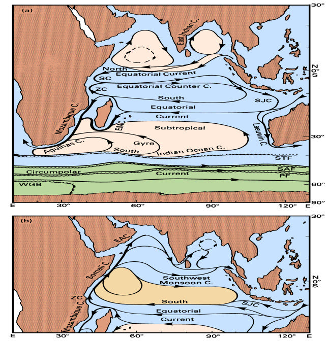
B. DETAILED DISCUSSION OF PRIORITY AREAS FOR ASSESSMENT & DATA
GAPS
Technically, LMEs are defined using criteria such as bathymetry, hydrography, productivity and
trophodynamics. The Somali LME (figure 2) extends geographically south-to-north from the
Comoros Islands and the northern tip of Madagascar to the horn of Africa. The ocean circulation
system here is largely dominated by the Indian Monsoon regime and exhibits a unique reversal of
ocean currents with season. The Agulhas LME (see Figure 1) includes the Agulhas Current proper
along the east coast of South Africa, as well as its source regions in the Mozambique Channel and
east of Madagascar. This is a typical western boundary current system, the largest of its kind in the
world. The island States included in this proposal (Mauritius, Comoros, Seychelles and
Madagascar) are all influenced by the South Equatorial Current that carries water from the east
Indian Ocean to the west. For illustrative purposes maps depicting the ASCLMEs are included
below
77
Note: The circulation South of 20O latitude remains relatively unaltered seasonally.
The environmental assessments that will be commissioned under the project are aimed at improving
understanding of the physical, chemical and biological characteristics of the ASCLMEs. The
information is needed to finalize the Transboundary Diagnostic Analysis and Strategic Action
Programme for these LMEs, enabling the participating countries to institute adaptive management
regimes for these systems. This annex summarizes the target areas for the assessments, both in
terms of geographic focus and thematic coverage. The targets have been arrived at following an
iterative process of prioritisation and stakeholder validation. Three workshops have been convened
to inform this process, namely: 1) workshop held in Maputo, Mozambique (September 2002), 2) a
Science Planning Workshop in Dal Josafat, South Africa (May 2004); and 3) a Regional
Information Workshop in Grahamstown, South Africa (October 2004). The targets were further
informed based on an exhaustive review of available information on the LMEs (Roman and
Lutjeharms, 2004). The priorities were informed 1] based on management needs, including the
reduction of coastal pollution, management of fish stocks, restoration of damaged habitats and
achievement of economic benefits; and 2] based on the extent to which they add to understanding
of transboundary threats and effects that need to be mitigated at the regional level, and ecosystem
functioning (at the scale of the LMEs)60.
Generic Assessment Areas
A key issue that needs to be addressed, in instituting an ecosystem approach to LME management
is: what aspects of the marine ecosystem of the ASCLMEs and thus the cross-border fisheries are
most easily disturbed by human interference and climate variability? This is a cross cutting concern,
the answers to which require a solid understanding of the oceanographic conditions of the region,
and their relationships to ecosystem dynamics, and ultimately, to the health of the region's fisheries.
A number of generic questions will need to be addressed in order to establish these understandings:
a) What are the inshore circulation patterns in the ASCLMEs and how do these affect local
habitats?
b) Does the circulation of Eastern Africa, Madagascar and the islands of the Indian Ocean play a
critical role in global thermohaline circulation and thus in climate variability and global climate
change?
c) What components of the offshore circulation affect the circulation of shelf regions in the
ASCLMEs and thus the distribution of marine organisms?
d) What are the water characteristics, water quality indexes and water circulation patterns on the
shelf regions of the ASCLMEs that have the most marked effects on trans -boundary
ecosystems, and thus living marine resources?
e) What are the most important components of terrestrial run-off that influence coastal ecosystems
and their health?
A number of specific issues have been identified within each of the above generic assessment areas.
Specific Priority Assessment Areas
A. WHAT ARE THE INSHORE CIRCULATION PATTERNS IN THE ASCLMES AND HOW DO THESE
AFFECT LOCAL HABITATS?
1. What is the inshore circulation pattern along the coasts of Kenya and Tanzania and how
does this affect the ecosystems? The offshore currents along the coasts of Kenya and Tanzania
have been extensively studied as part of previous international oceanographic investigations. The
fisheries of both these countries are largely artisanal and include prawn fisheries. Information gaps
on environmental conditions and their variability in space and time are most significant in inshore
60 The following criteria were established in defining the assessment priorities. First, they must be
scientifically defensible. Second, they must fill the most critical knowledge gaps that currently preclude
management of trans-boundary LMEs and their constituent living resources. Third, they must provide socio-
economic benefits for all the countries of the region (i.e. contribute to efforts to maintain food security, or
plan response measures to natural disasters). Fourth, they must add value to existing information. Fifth, they
must be cost effective and achievable.
78
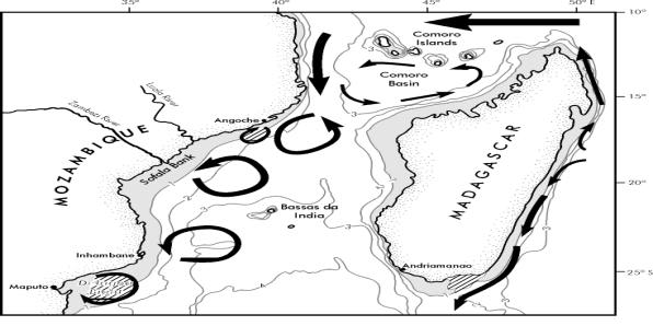
regions. The inshore circulation may play a defining role in many of the processes that affect
artisanal fisheries, including the movement of fish and fish larvae, recruitment, and environmental
conditions.
2. What components of the inshore circulation affect the circulation on shelf regions in the
SWIO and thus the distribution of marine organisms and the geographic structure of marine
ecosystems? The inshore circulation, i.e. at the shelf edge, has a decisive influence on most shelves
of the South West Indian Ocean (Lutjeharms, 2004), particularly where the shelf is narrow (see
Figures 1 and 3). An understanding of shelf circulation in turn is crucial for an understanding of the
movement of organisms, such as fish larvae, and the dispersal of pollutants. Such circulation occurs
across boundaries and carries marine organisms with it. Lack of knowledge as well as data on the
effect of onshore currents on shelf circulation is one of the major gaps that need to be filled if the
trans-boundary living resources are to be managed effectively. Studies of these processes will help
build local scientific and management capacity and create skills in areas most useful to LME
management.
3. What are the shelf and coastal circulation patterns along the East Madagascar shore line?
The narrow shelf east of Madagascar (see Figure 3) is one of the least studied shelf regions in the
world's oceans. Only one partial investigation of fish resources has been undertaken on part of the
shelf, and that was 20 years ago. The knowledge of shelf and coastal circulations as well as
biodiversity is largely non-existent, making proper environmental management impossible. A
baseline study of hydrodynamics and biodiversity is clearly urgently called for. This coastline is in
many respects ideal for tourism and this is being considered for the future. A thorough investigation
will establish a reference level against which possible future pollution and environmental
degradation can be measured. A first, proper hydrographic survey of this current and its variability
will give a very solid understanding on the effect of the ocean environment on this coastal region.
This may at first glance seem a problem of national importance, but based on limited current
knowledge, this seems not to be the case. Shelf water and organisms of this shelf area are known to
be moved by vortex dipoles from the southern branch of this current into the Mozambique Channel
and to the Agulhas Current; there is seeding potential for organisms of the latter regions and thus
there are cross-boundary aspects.
Figure 3. The general circulation in the vicinity of Madagascar and the Mozambique Channel. Shaded areas
denote the continental shelves shallower than 1000 m. Lined regions indicate upwelling cells. The bathymetry
is given in km.
79
B. DOES THE CIRCULATION OF EASTERN AFRICA, MADAGASCAR AND THE ISLANDS OF THE INDIAN
OCEAN PLAY A CRITICAL ROLE IN GLOBAL THERMOHALINE CIRCULATION AND THUS IN CLIMATE
VARIABILITY AND GLOBAL CLIMATE CHANGE?
4. What are the implications of the Somali Current upwelling on issues related to
environmental variability? It is well established that the Western Indian Ocean is the site of some
of the most dynamically varying LMEs that exist on the planet61. The Somali Current develops
during the southwest monsoon to become the fastest open-ocean current in the world62, and the
coastal upwelling that occurs along the African coast during the intensified phase of the Somali
Current constitutes the most intense large -scale seasonal coastal upwelling system in the world. The
Findlater Jet (that extends from the Somali coast out over the Arabian Sea) is the strongest low-
level atmospheric jet that exists as a regular feature anywhere in the world63. In addition, the
northwestern Indian Ocean has been identified as a major zone of methane emissions (methane
being a particularly potent greenhouse gas, some 21 times as effective as carbon dioxide, per unit
weight, in driving global warming)64. However the dynamics underpinning these processes and
environmental variability remain poorly understood.
5. What are the more precise linkages between the Asian-Australian monsoon and the global
climate system? The Asian-Australian (AA) monsoon, which is a highly significant factor within
the Somali and Agulhas LMEs, is a key component of the earth's climate system and affects the
livelihood of more than 60% of humanity. Better predictions of the monsoon will greatly benefit the
social and economic well-being of this large segment of the world's population 65. In addition, there
is strong linkage of the AA monsoon system to the global climate system, and thus improved
understanding and prediction of the AA monsoon is not only crucial to the WIO but also globally.
Past studies have shown that the AA-monsoon is linked to interannual variability of the tropical
ocean-atmosphere system, such as the El Nińo Southern Oscillation (ENSO) and the tropical
biennial oscillation, and other studies suggest that the AA-monsoon may strongly impact the
climate outside the monsoon region, including extratropical North America66. Indeed, a primary
goal of the CLIVAR-GOALS project of the WMO/IOC/ICSU World Climate Research Programme
is to better understand ". . . the role of the AA-monsoon on the predictability of the global climate
system, in particular parts related to ENSO." The project will accordingly develop a close working
relationship with CLIVAR.
6. What are the precise effects of the unique biological and physical characteristics of the
Mascarene Plateau on the surrounding parts of the Agulhas and Somali LMEs? The
Mascarene Plateau arches across the Western Indian Ocean from the Seychelles down to Mauritius,
with water depths up to 100 m. The area supports a wide diversity of ecosystems with potential for
exploitable resources. The Plateau extends as a fault-composite arc for 2,300 km from the Equator
southwards, with water depths ranging from 0 to 100 m67. It is a strong topographic feature, and
probably acts as a barrier to latitudinal water flows in the Western Indian Ocean, and thus is of
distinct, regional importance. Management of marine resources over large ocean areas provides a
great challenge. Despite extensive studies in many of these large ocean areas, the interaction of
physical and biological processes in large shallow mid-oceanic areas, such as the Mascarene
Plateau is not well understood.
q The climate regime of the Indian Ocean (monsoons and trade winds) is influenced by its
geography and its proximity to two large continental masses. However, the impact of the
61 Bakun, A., S. Lluch-Cota and C. Roy. 1998. Coastal upwelling and other processes regulating ecosystem
productivity and fish production in the western Indian Ocean. p. 103-141. In: K. Sherman, E. Okemwa and
M. Ntiba, (eds.) Large Marine Ecosystems of the Indian Ocean: Assessment, Sustainability, and
Management. Blackwell Science Inc. Malden, MA. USA.
62 Ibid
63 Ibid
64 Bakun, A. and S.J. Weeks. 2004. Greenhouse gas buildup, sardines, submarine eruptions, and the
possibility of abrupt degradation of intense marine upwelling ecosystems. Ecology Letters 7: 1015-1023.
65 CLIVAR Project website: http://www.clivar.org/index.htm
66 Ibid
67 It is also described as a distinct shelf of continental origin (Mart, 1988).
80
Mascarene Plateau on these phenomena remain poorly understood and understanding of the
climate regime is undermined by the lack of a specific climatic description for the area68.
q An intense Indian Equatorial Jet (EJ) signals the transition from the northeast to southwest
monsoons. The behaviour of this jet is, however, still not well known. Research shows that in
any particular year the jet appears within the three-month window AprilJune as a feature of
shorter (one-month) durations with higher peak velocities. Although it is on average a weak
feature it may nonetheless result in a distinct physical forcing. As this could have an influence
on productivity (and thus fisheries), improved understanding of this phe nomenon is seen as
important.
7. Does the circulation off western Africa, Madagascar and islands of the South West Indian
Ocean play a critical role in global thermohaline circulation and thus in climate variability and
global climate change? Considerable effort has been expended over the past decade in studying the
manner in which the greater Agulhas Current contributes to the global thermohaline circulation. It
has been demonstrated, through many international studies that it plays a crucial role in inter-ocean
exchanges of water and that variations to these fluxes contribute to changes in climate variability.
These results naturally have an enormous, but indirect, socio-economic impact. A number of key
problems that require further investigation have been identified. Many of these do not require any
observations at sea but can be researched through modelling , remote sensing and theoretical
studies:
q What is the frequency of shedding of Mozambique eddies? It has recently been demonstrated
that the main currents of the Mozambique Channel consist of anti-cyclonic eddies formed at the
narrows of the Mozambique Channel from where they move in a polar direction. These eddies
carry heat and momentum that are a component of the global thermohaline circulation. An
increase or decrease in the shedding frequency of these eddies therefore may have global
implications. Furthermore, these eddies have been implicated in triggering Natal Pulses and
thus in the inter-ocean exchanges of water between the Indian and Atlantic Oceans. With regard
to their impact on climate change, they are therefore of substantial importance. A sophisticated
array of current meter moorings placed in the Mozambique Channel narrows by a research team
from the Netherlands are currently monitor ing the shedding of eddies. This work could be
supported by the placement of hydrographic stations through eddies on research cruises as well
as by altimetry.
q The triggering of Mozambique eddies Mozambique eddies move past the shelves of the coast of
Mozambique where it has been observed that they draw water from the shelves into the deep
sea. It is probable that they also affect the circulation of water on the shelves. In addition, they
carry Indo-Pacific organisms from the tropics across political boundaries. It is not known what
effect the Mozambique eddies have on the shelves of Madagascar, since there are no adequate
hydrographic data for that region. It is therefore important to establish what factors or driving
forces trigger the shedding of a Mozambique eddy. This could probably be most effectively
done by analysis of remote sensing products and by the judicious use of modelling.
Hydrographic observations in eddies will be of enormous value in establishing their nature and
dynamics.
q Penetration of Red Sea Water in the South West Indian Ocean: The general, averaged motion of
Red Sea Water into the ASCLMEs region has been established. However, it is not clear how
Red Sea Water reaches various parts of this ocean region: does it come in a seasonal manner, in
irregular occurring filaments or is it a continuous process? Understanding this cross-boundary
process is important from a climatology point of view since this process has an impact on the
global thermohaline circulation as well as on inter-ocean exchanges of water masses. The
analysis for this project will have to be based on existing hydrographic data, but new additions
of data in places in the ASCLMEs where no data are currently available will be of immense
value. These data could be collecte d during cruises in designated regions where knowledge
gaps need to be filled.
q Movement of South Equatorial Current eddies and their impact: It has been shown
unequivocally that eddies embedded in the South Equatorial Current, on reaching the east and
68 A few studies were undertaken in the 1990s by the INDOEX research project (Ramanathan et al., 1995)
81
south coast of Madagascar as well as the region of the Comoros and the Mozambican coast,
have a decided impact on the local circulations. Furthermore, it has been suggested that they
play a triggering role in what may be considered the greater Agulhas Current system. This
triggering role may have substantial climatological effects and thus influence global climate
change. Comprehensive international studies are underway to study these effects, but they are
limited to modelling and analyses of satellite remote sensing. Hydrographic observations at sea
in any of the ASCLMEs regions where these eddies are to be found would be of value in
establishing their hydrographic and dynamic natures and thus their role in affecting climate
patterns and variability.
WHAT COMPONENTS OF TH E OFFSHORE CIRCULATION AFFECT THE CIRCULATION OF SHELF
REGIONS IN THE ASCLMES AND THUS THE DISTR IBUTION OF MARINE ORGANISMS?
8. What is the influence of the South Equatorial Current on the shelf circulations of the
WIO islands? The Seychelles, Mauritius, Reunion and other islands have in many respects similar
oceanic environments. They are open to deep-sea circulatory effects due to a very narrow shelf and
are all influenced by the South Equatorial Current coming from the east (see Figure 1). This Current
may be affected by lateral Rossby waves and by perturbations in the form of eddies. The effect of
these on the marine environments of the islands is very poorly understood. This needs to be
rectified. In most cases the economies of these islands depend increasingly on nature-based tourism.
Coastal pollution, and climate change induced habitat destruction (such as bleaching of coral reefs)
are aspects influenced by offshore currents and their variability. All in turn have direct economic
implications.
9. What are the determinants of forcing of the South Madagascar upwelling cell? A number
of previous investigations have pointed to the existence of an upwelling cell off the southeast coast
of Madagascar. This shelf upwelling cell does not seem to be wind-driven, but rather driven by the
passing southern branch of the East Madagascar Current. To date, only one research cruise vessel
has tangentially) investigated the feature. This upwelling cell may have substantial socio-econo mic
implications. There is some anecdotal evidence that fishing in the region is enhanced, but this has
not been investigated rigorously. There are also indications that the organisms and larvae from this
region may supply recruits for parts of the Mozambique Channel and for the shelves adjacent to the
Agulhas Current proper, thus making this region of cross-boundary importance for the management
of living resources. Habitat classifications, resource identification and taxonomic work need to be
carried out. The driving forces of the cell and their variability need to be understood in order to
manage potential fisheries.
10. How is the Angoche upwelling cell shaped? Information on primary productivity and its
relation to fisheries is generally limited for the whole ASCLMEs region. Nevertheless, a number of
prime locations for urgent investigation stand out. One is the coastal upwelling cell off southern
Madagascar (see preceding bullet). Very little is known on the primary productivity here. On the
western side of the Mozambique Channel there is slightly more information and it has been
demonstrated that the highest primary productivity, by far, is to be found in an upwelling cell off
Angoche (see Figures 3 and 4). The relationship of this feature to local fisheries and fisheries
further downstream is imperfectly understood. The role of this cell in generating recruits for
fisheries downstream makes this an important cross-boundary issue. The sustainability of this
upwelling cell, its variability, its contribution to biodiversity and its driving forces are currently not
well understood.
82
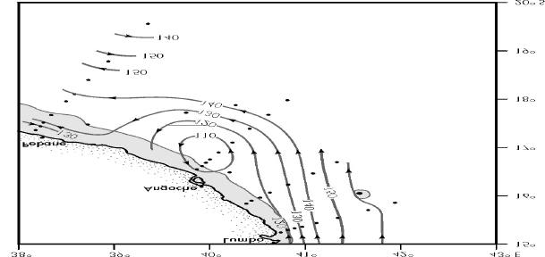
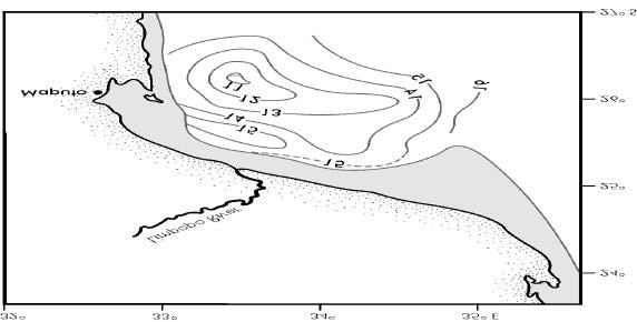
Figure 4. The flow pattern around the Angoche upwelling cell along the coast of Mozambique (see
Figure 2 for general location) according to a cruise undertaken in 1980. After Lutjeharms (2004). Black
dots denote the location of hydrographic stations. The most intense upwelling and highest values of
chlorophyll-a on this occasion occurred within the 110 isoline. These isolines give the dynamic
topography of the sea surface relative to 600 dbar in dynamic centimetre.
11. What is the influence of Mozambique eddies on the adjacent shelf waters? While past
investigations have shown that a Mozambique current does not exist as such, large, anti-cyclonic
ocean eddies are formed in the narrows of the Mozambique Channel and these eddies move along
the western shelf creating the illusion of a western boundary current (see Figures 1 and 3).
Confirmation of this scenario is very recent. This has crucial importance for an understanding of the
circulation on the shelves off the Mozambican coast, their ecology, their role in sustaining local and
downstream biodiversity and their consequent role in sustaining local and downstream fisheries. It
has been demonstrated that passing Mozambique eddies draw off water and phytoplankton from the
shelves in this region. This is only one aspect that requires investigation in order to secure a better
understanding of underlying ocean variability--in turn needed to ensure living marine resources are
effectively managed.
83
Figure 5. The eddy in the Delagoa Bight of the Mozambican coast (see Figure 3 for general location in the
Mozambique Channel). The shaded area is the continental shelf shallower than 1000 m. Isolines are the
isotherms at a depth of 200m showing the upwelling of cold (< 10ş C) water in the centre of the cyclonic
eddy.
12. What are the factors underpinning the driving of the Delagoa eddy? In the Delagoa
Bight, off Maputo, the capital of Mozambique, a recurrent and persistent cyclonic eddy is found
(see Figures 3 and 5, above). This resident shelf edge circulation is believed to be driven by passing
Mozambique eddies, but no firm confirmation for this hypothesis is as yet available. Only one
research cruise has been undertaken in the area to study the feature. This eddy is known to
influence the shelf circulation, the disposition of river outflows, the dispersion of pollutants and
thus the habitat of organisms and potentially the important prawn fisherie s. Since this feature is
close to the South African border, it may well play an important role in cross-boundary living
resources. In order to establish the driving forces for this eddy and its role, satellite remote sensing
and a research cruise are required. Mapping of biotopes in this feature and in the adjacent shelf
region should be carried out.
13. Where does the Agulhas Current start to influence the shelf circulation off
Mozambique/South Africa? It is a remarkable fact that the location at which the Agulhas Current
proper starts to affect the motion of shelf waters on the Mozambican/South African shelf is not
known. To date this location has only been surmised from patterns of the shelf sediments northeast
of Durban (see Figure 6). Knowing this location is crucial not only for an understanding of shelf
circulation between Durban and Maputo, but also for a better knowledge of the ecology of cross-
boundary living resources and the dispersion of pollutants from Mozambique and Maputoland
South. The placement of current meter moorings would be sufficient to fill this important
knowledge gap.
14. What factors contribute to the driving of the St Lucia upwelling cell and what is its
effect on the Natal Bight? The Natal Bight is a semi-enclosed part of the shelf of southern Africa
lying between Cape St Lucia and Durban (see Figures 7 and 8). It is the widest part of this shelf
region and is bordered on the seaward side by the Agulhas Current. It creates a somewhat
specialized habitat with a number of endemic species. Other living resources migrate equatorward
to the bight from further downstream. There are some indications that the living resources of the
bight are not independent from those across the Mozambican border slightly to the north, making
this a relevant case for cross-boundary management. A coastline that is partly highly industrialized
and partly used for intensive tourism and eco-tourism borders the Natal Bight. The waters of the
bight are therefore the recipient of considerably urban and industrial runoff and pollution. A
number of rivers discharge their waters into the region. The marine ecology of the bight is highly
unusual. It seems that an upwelling cell at Cape St Lucia, driven by the passing Agulhas Current,
supplies all the nutrients to maintain the primary productivity in the bight (see Figure 7). This
makes an understanding of this upwelling cell crucial to an understanding of the whole
oceanography and ecology of the Natal Bight. Without this understanding, effective management of
the living resources is not possible. Currently, there is no information on the variability of the Cape
St Lucia upwelling cell, its lasting influence on the waters and ecosystem of the bight as a whole or
on the forces that drive the upwelling. Information could be obtained by placing a set of current
meter moorings at this upwelling cell.
84
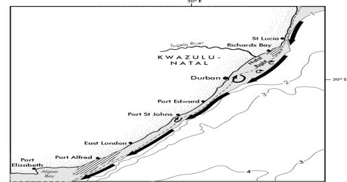
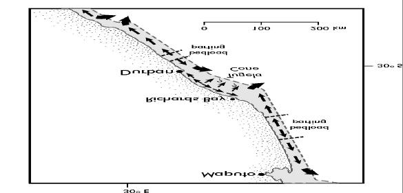
Figure 6. The inferred bedload motion along the coastline between South Africa and Mozambique, after
Lutjeharms (2004). The bedload parting equatorward of Richards Bay may give an indication of where the
Agulhas Current starts having an influence on shelf waters.
Figure 7. A portrayal of the general circulation off the east coast of South Africa. Lined regions denote
where upwelling is known to occur; shaded regions are shallower than 1000m. Note the narrowness of the
shelf and the way in which the Agulhas Current follows the shelf edge if there is no Natal Pulse present.
13. What is the effect on shelf water of the Natal Pulse? The Natal Pulse is an unusual
perturbation on the trajectory of the Agulhas Current (see Figure 1 and 7). Its behaviour is crucial to
an understanding of the Agulhas Current, the Agulhas retroflection and the role of this current in
the global thermohaline circulation. It has also been demonstrated on a few individual occasions
that the passing of the Natal Pulse has a dominating effect on the water movement on the adjacent
continental shelf by reversing the currents dramatically and instantaneously. This process may play
a key role in the movement of organisms along this coastline from the Agulhas Bank to the Natal
Bight, in the annual sardine run, in the migration of whales and in the distribution of immotile
organisms and larvae. It probably also has a decisive influence on the dispersion of pollutants on
the shelf of this region. A proper understanding, based on appropriate data of the effect on shelf
waters of the passing of Natal Pulses is essential if the fish resources of the eastern seaboard are to
be properly managed.
85

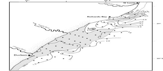
Figure 8. A portrayal of the Cape St Lucia upwelling cell and its influence on the Natal Bight waters. Dots
represent station positions. The shaded region is shallower than 200 m.
Figure 9. A composite of outlines of cold water (< 17şC) of the Port Alfred upwelling cell, after Lutjeharms,
2004. The shelf shallower than 200m has been shaded.
What forces drive the Port Alfred upwelling cell and what is its effect on the Agulhas
Bank?
14.
The Agulhas Bank is a wide part of the shelf at the southern tip of South Africa (see Figure
1). It plays a crucial role in the west coast ecosystem of southern Africa and is thus a prime region
for cross-boundary ecosystem mana gement. It is here that the major economically important species
such as anchovy and sardine spawn. It has been demonstrated that the environmental conditions on
the bank during critical stages of the spawning period are crucial to the success, or failure, of that
year class. A full understanding of the hydrodynamic working of the Agulhas Bank is therefore
essential to the proper management of these cross-boundary living resources. It has enormous
socio-economic consequences, but major knowledge and data ga ps exist in this regard. It has been
shown that there is a high likelihood that the upwelling cell found at Port Alfred carries cold water
onto the shelf and here forms the bottom waters of the whole Agulhas Bank, thus enhancing the
seasonal thermocline and creating a favourable habitat for the spawning of fish. The process
through which this occurs is not understood. In order to evaluate and understand the role of this
86
upwelling cell, the driving forces need to be evaluated, the variability of the upwelling cell needs to
be monitored and the effect of the cold water thus upwelled on the rest of the shelf determined. To
answer these questions adequately placement of current meter moorings at the upwelling cell as
well as a proper, multi-disciplinary cruise encompassing the whole of the Agulhas Bank quasi-
synoptically should be carried out.
WHAT ARE THE WATER CHARACTERISTICS, WATER QUALITY INDEXES AND WATER
CIRCULATION PATTERNS ON THE SHELF REGIONS OF THE ASCLMES THAT HAVE THE
MOST MARKED EFFECTS ON TRANS -BOUNDARY ECOSYSTEMS , AND THUS LIVING MARIN E
RESOURCES ?
15. Water quality of shelf waters have a decided influence on pollution, habitat destruction and thus
fisheries and tourism. In many areas of the ASCLMEs there is no information of any kind on the
water movement, water characteristics, water quality or the cross-boundary exchanges of water
masses and biota. This precludes any management of cross-boundary living resources or
biodiversity. Assessments are needed to establish baselines in the shelf areas of WIO Islands, East
and West Coast of Madagascar69, and coastlines of East Africa70.
WHAT ARE THE MOST IMPORTANT COMPONENTS OF TERRESTRIAL RUN-OFF THAT INFLUENCE
COASTAL ECOSYSTEMS AND THEIR HEALTH ?
q Saline and fresh water runoff on the Sofala Bank: The Sofala Bank is one of the widest and
shallowest shelf regions in the proposed ASCLMEs (see Figure 10). It is the recipient of
substantial amounts of fresh water from the Zambezi and other rivers as well as saline inputs
from the salt marshes in the vicinity of Beira. These inflows are by no means continuous.
Occasional summer floods from the Zambezi River could conceivably overwhelm the saline
surface waters of a large part of the adjacent shelf, whereas during dry periods the saline fluxes
from salt marshes could be dominant. Neither of these hypotheses has been tested by
appropriate observations, which is problematic for management purposes as the region supports
an important fishery. Little is known about the distribution of biotopes and the habitats have not
been adequately classified.
q Limpopo runoff on the ecosystem of the Delagoa Bight: One of the largest rivers in the
ASCLMEs region is the Limpopo River that drains into the Delagoa Bight (see Figure 5). It has
been conjectured that the economically important prawn fisheries of this region benefits from
the organic material contributed by the runoff from this river. Biotopes in the region have not
been adequately mapped nor have complete taxonomic determinations been carried out.
Investigations using satellite remote sensing and well-focused hydrographic observations in the
Delagoa Bight would go a long way to filling some of the knowledge gaps currently hindering
management.
q River runoffs from Madagascar: All the criteria for including land runoff onto adjacent
shelves in a list of priority actions hold equally for the river runoffs from Madagascar. These
include filling knowledge gaps needed better to manage living resources, biodiversity and
possible cross-boundary fish stocks. Biotopes need to be mapped and potential living resources
identified. However, there seems to be no information whatsoever on the influence of river
runoff on the Madagascar shelves. Two ways of approaching this information gap are foreseen.
One is to include such an investigation in an exploratory cruise on the shelves of Madagascar
and its adjacent current systems. The other, perhaps complementary, study would involve
69 The shelf of Madagascar are in most respects mare incognitum. Hardly any measurements of an
oceanographic nature have been carried out. The shelf west of Madagascar is wider than the East coast shelf,
and is not bordered by a strong western boundary current. The characteristics of its waters and biota may
therefore be entirely different.
70 The shelf waters of the Somali system are of substantial importance for the artisanal fisheries of the East
African coast. A question that needs to be addressed is how dependent is the shelf circulation on the reversing
monsoonal winds and how much on the seasonality of the offshore Somali Current? How much does this vary
from year to year and what impact does this variation have on the fish stocks, it at all?
87
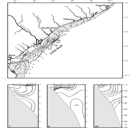
smaller vessels that could carry out monitoring work on a more regular basis at predetermined
locations.
Figure 10. One-time observations of the effect of freshwater runoff from the Zambezi River on the waters of
the Sofala Bank in the Mozambique Channel. The upper panel shows the salinities at the sea surface with low
salinity region not shaded. The lower panel shows three vertical sections marked in the upper panel of
salinity. Dots denote station position in the upper panel, vertical marks the same in the lower panels.
88
ANNEX 8:
PROGRAMME AREAS, LME MODULE, AND FUNDING
SOURCE
Programme Area
Interventions/LME Module
Funding Source
ASCLMEs Project Objective: To fill
Four specific Outcomes:
ASCLMEs Project, with additional
prioritised knowledge gaps in
·
Filling of key identified
financial contributions from SWIOFP
understanding of transboundary living
knowledge and information gaps
for joint cruises, and WIO-LaB for
resources of the two LMEs and to build
(Productivity Module/ fisheries and
public participation activities.
capacity of the participating countries to
pollution module)
utilize this improved understanding for
·
Building project, Programme and
more effective management through use
Long-term monitoring and evaluation
of a modular approach to ecosystem
system Governance and Socio-
management.
economic Module);
·
Mainstreaming (Governance and
Socio-economic Module); and
·
Public Participation Programme
(Socio -economic Module).
Outcome: Key environmental knowledge
Fill gaps in identified priority areas in
ASCLMEs Project, with support from
gaps are filled as necessary to install an
oceanographic processes and
SWIOFP on joint cruises, and WIO-
ecosystem approach to LME
environmental variability ((Productivity,
LaB on near-shore areas of
management;
fisheries and Pollution and Ecosystem
productivity in relation to pollution
Health Modules): Specifically, among
hotspots.
others, system productivity in near-shore
and off-shore area; larval transport;
anthropogenically induced environmental
variability; role of gyres and eddies in
productivity
Outcome: Decision-making tools are in
Defraying country and regionally based
ASCLMEs Project, working with
place, to facilitate the synthesis and
transaction costs to jointly establish
WIO-LaB for M&E related to coastal
application of data for LME
monitoring and evaluation approaches
land based sources pollution, and
management;
based on IW indicators. (Socio -econo mic,
SWIOFP for issues related to
Governance, and Fish and Fisheries
demersal, pelagic and crustacean
Modules)
fisheries.
Outcome: Foundational capacities are in
1) Defraying the transaction costs of
1) ASCLMEs Project working with
place to assure the sustainability of
national and regional discussions aimed at
WB and UNEP partners in the areas of
assessment and data management
legislative and regulatory changes
donor recruitment and other measures
activities to be undertaken in the sap
consistent Programme and project
aimed at leveraging necessary human
implementation phase;
objectives, donor recruitment, and the
and financial investments to achieve
establishment of other mechanisms aimed
sustainability of management and
at Programme and project financial
Programme and project outcomes. 2)
sustainability (Governance Module).
ASCLMEs Projects working with
2) Capacity building during project
WIO-LaB on capacity building for the
implementation and leveraging of
pollution and ecosystem health module
resources to assist countries retain trained
of the MA, and with SWIOFP on the
personnel (Socio-economic Module).
fish and fisheries module.
Outcome: A Comprehensive Public
1) De-mystifying science to benefit of
ASCLMEs Project with additional
Participation Initiative Enables
Stakeholders (Socio -economic Module);
support from WIO -LaB for
Stakeholders to Engage in Programme
2) Stakeholder forums (Socio-economic
stakeholder for a, and from SWIOFP
activities.
Module);
and WIO-LaB for establishment and
3) Environmental Education Initiatives
maintenance of Programme
(Socio-economic Module);
component of the dedicated web site.
4) Establishment of Project and
Programme Web Site (Socio-economic
Module).
SWIOFP Project Objective:
Seven specific Outcomes:
SWIOFP, in collaboration with
(i) To identify and study exploitable
(Fish and Fisheries, Socio-economic,
ASCLMEs Project and WIO-LaB in
offshore fish stocks within the SWIO, and Pollution and Ecosystem Health and
relation to capacity building and
differentiate between environmental and
Governance Modules)
fisheries interactions with non-
89
anthropogenic impacts; (ii) To develop
·
Identify exploitable offshore fish
consumptive resources.
institutional and human capacity through
stocks ; develop inst. Capacity; develop
training and career building. (iii) To
regional fisheries management. (Fish
develop a regional fisheries management
and Fisheries Module));
structure and associated harmonized
·
Do baseline assessment and
legislation in collaboration with the
assess crustacean fisheries by-catch
SWIOFC.
(Fish and Fisheries Module);
·
Do baseline assessment of
demersal stocks in targeted areas;
·
Develop and test fisheries
monitoring techniques;
·
Baseline assessment of fisheries
interactions with non-consumptive
marine; and
Strengthen national fisheries
management.
Outcome: Regional database piloted
Regional database piloted and ranked
SWIOFP, with assistance from
and ranked effective by majority of
effective by majority of SWIOFP
ASCLMEs Project on data base
SWIOFP countries (Fish and Fisheries
countries (Fish and Fisheries and Socio-
creation and gaps in knowledge on
and Socio-economic Modules);
economic Modules); Production of a gap-
fisheries information.
Production of a gap-analysis which
analysis which identifies gaps in
identifies gaps in knowledge of SWIO
knowledge of SWIO fisheries resources
fisheries resources and presents
and presents research agenda to be
research agenda to be implemented by
implemented by SWIOFP (Fish and
SWIOFP (Fish and Fisheries Module);
Fisheries Module); historic data identified
historic data identified for inclusion in
for inclusion in database/data atlas
database/data atlas sourced or entered
sourced or entered into database
into database
Regional fisheries database fully
Regional fisheries database fully
operational and inclusive (Fish and
operational and inclusive (Fish and
Fisheries and Socio-economic Modules);
Fisheries and Socio-economic
National fisheries related IT and
Modules); National fisheries related IT
communications infrastructure procured
and communications infrastructure
or upgraded for each of nine SWIOFP
procured or upgraded (Fish and
countries (Fish and Fisheries and Socio-
Fisheries and Socio-econom ic Module);
economic Module); and Training in data
and Training in data handling and
handling and reporting provided for each
reporting provided ( Fisheries and
of nine SWIOFP countries (Fish and
Socio-economic Modules).
Fisheries and Socio-economic Modules).
Outcome: (I) Baseline assessment of
Survey methodology defined and found
SWIOFP, and in cooperation with
shallow and deep water crustacean
scientifically sound (Fish and Fisheries
ASCLMEs Project on ecosystem
stocks and fisheries in the EEZs of
Module);
measurements.
Mozambique, Kenya, South Africa,
Seven ship-based surveys and data
Tanzania, Seychelles, Madagascar and
collection exercises to assess the potential
Comoros.
of new and existing fisheries (Fish and
(ii) Assessment of crustacean fisheries
Fisheries Module); Production of
by-catch, evaluation of discard impacts,
preliminary country reports and
testing of exclusion devices, and
consolidated sub-regional reports on
measurements of ecosystems impacts in
status of crustacean fisheries (Fish and
selected areas of the SWIO.
Fisheries and Socio-economics Modules);
pilot studies on optimising artisanal
shallow-water lobster fisheries completed
Outcome: (i) Baseline assessment of
Survey methodology defined and found
SWIOFP
demersal stocks and fisheries in the
scientifically sound (Fish and Fisheries
EEZs of Kenya, Tanzania,
Module); ship-based surveys and data
Mozambique, South Africa, Seychelles,
collection exercises to assess the potential
Comoros and Madagascar.
of new and existing fisheries (Fish and
Fisheries Module); Production of
preliminary country reports (Fish and
Fisheries and Socio-economic Modules);
90
and consolidated sub-regional reports on
status of demersal fisheries (Fish and
Fisheries and Socio-economics Modules).
Outcome: Monitoring of fishing effort
Scientific sea observers trained (Fish and
SWIOFP, in cooperation with
and catch . Development and testing of
Fisheries Module); Improvement in
ASCLMEs Project and WIO-LaB on
fisheries monitoring techniques and
frequency and coverage of national
development of monitoring systems.
linkage of communication infrastructure
monitoring activities in each country
and development of coordination
(Fish and Fisheries and Socio-economic
mechanisms and verification systems.
Modules); Initiation of land based
monitoring and data verification systems
in at least half of participating countries
(Fish and Fisheries, Socio-economics, and
Governance Modules); Initiation of
discharge monitoring Programme in at
least half of participating countries
(Pollution and Ecosystem health and
Governance Modules); Two aerial
surveys and data collection to monitor
fishing effort in select areas of the SWIO
(Fish and Fisheries and Socio-economics
Modules); and Initiation of a regional
Vessel Monitoring System (Fish and
Fisheries and Governance Modules)
Outcome: Baseline assessment of
Development of guidelines for research
SWIOFP, in cooperation with
fisheries interactions with non-
grant proposals completed (Fish and
ASCLMEs Project on GIS work and
consumptive marine resources and
Fisheries and Socio-economics Modules);
key marine species.
assessment of marine biodiversity as
Research studies on interaction between
alternative sources of income
commercial and non commercial marine
resources or potential alternative
livelihoods completed Fish and Fisheries
and Socio -economics Modules); Key
marine species GIS mapped SWIOFP
countries (all except Réunion) Pollution
and Ecosystem health Module); and bio -
indicator species identified and
relationships between target species and
ecosystem health established (Fisheries
and Socio -economics Modules).
Outcome: Strengthening of Regional and
Evaluation of national fisheries regulations SWIOFP, with collaboration of
National Fisheries Management.
and identification of areas where
ASCLMEs Project and WIO-LaB on
Development of regional fisheries
harmonization is needed completed (Fish
harmonization and workshop
management framework and support to
and Fisheries and Governance Modules);
activities.
regional and national fisheries
Establishment of working relationship and
management bodies.
technical support between SWIOFP and
Southwest Indian Ocean Fisheries (Fish
and Fisheries and Governance Modules);
Regional PMU and national project offices
in place; and national level workshops to
disseminate project outputs and develop
follow on activities (Socio-economics
Module).
WIO-LaB Project Objective: To fill
Three specific Outcomes:
WIO-LaB
prioritised knowledge gaps in
(Governance, Socio-economics and
understanding of transboundary living
Pollution and Environmental health
resources of the two LMEs and to build
Modules)
capacity of the participating countries to
·
Strengthen regional legal basis
utilize this improved understanding for
for preventing land-based sources of
more effective management through use
pollution;
of a modular approach to ecosystem
·
Reduce ecosystem stress through
management.
sediment and water quality
91
improvements;
·
Develop regional capacity and
strengthen institutions for sustainable,
less polluting environment.
Strengthen regional legal basis for
Gaps identified in legal/regulatory regimes WIO-LaB
preventing land-based sources of
(Governance Module), ratification of
pollution
international agreements (Governance
Module); Regional EIA process
(Governance and Socio-economic
Modules); and National Plans of Action
(Pollution and Ecosystem Health
Modules).
Outcome: Reduce stress to the ecosystem
Common regional monitoring methods
WIO-LaB
by improving water and sediment quality agreed and pilot monitoring carried out
(Governance Module);
Improved knowledge of priority pollutants
and carrying capacity;
Regionally agreed EQOs and water-based
EQSs (Pollution and Ecosystem health
Module); and Six demonstration projects
successfully implemented (Pollution and
Ecosystem Health Module).
Outcome: Develop regional capacity and
Sustainable framework for managing land-
WIO-LaB, with strong support from
strengthen institutions for sustainable,
based sources, including updated
SWIOFP and ASCLMEs Project for
less polluting development
TDAs/SAPs (Governance and Socio-
finalization of the TDAs and SAPs
economic Module);
Enhanced capacity developed for
sustainable environmental management in
region (Governance Module); and
Fully involved stakeholders and improved
civil society (Socio-economics Module).
92
ANNEX 9:
PLANNING AND STRATEGY FOR THE OCEANOGRAPHIC SURVEYS
ASSOCIATED WITH THE ASCLMEs PROJECT
PROCEDURAL:
The Project will develop an Oceanographic Survey Workplan and Strategy during its first months (and prior
to the oceanographic field work), which will include the following components:
a) A final review of current knowledge to re-confirm `gaps' in the oceanographic record to guide the
planned cruises.
b) Identification of a detailed oceanographic survey plan for the ASCLMEs project lifecycle
(locations, vessels, timing, data collection and analyses, databases to be developed, etc). This will
include a contingency plan to extend/ expand survey sites or methodology as necessary to address
newly identified gaps.
c) Elaboration of a training and capacity building Programme through a selected counterparting
process using both regional specialists and those experts associated with the survey vessels and
their home institutions.
d) Identification of local/regional institutes and personnel most appropriate for the shipboard training
and capacity building Programme. This may also include appropriate training periods (especially
for data analyses) at the vessel `home' institutes.
e) Elaboration of a data handling (including quality assurance and control) and storage Programme to
include clear definition of the management uses and operational values of the data, and how the
data would be targeted at management agencies and institutions.
f) Adoption of an effective coordination mechanism for the various oceanographic and fisheries
cruises and use of vessel-time between the three projects under the overall Programme for the
ASCLMEs. This mechanism will also seek to develop cooperative partnerships with other field-
work initiatives which may be identified within the region and which could help to build the
information database or provide further training opportunities.
N.B. Items c) and d) will feed into the Project's overall Capacity Building and Training Programme.
This Workplan and Strategy will be discussed by the Cruise Coordinating Group (which will include
representation from the other GEF projects within the ASCLMEs Programme ), in the invited presence of
other pertinent stakeholder observers, at a cruise design workshop to ensure all parties are clear of the aims
and deliverables as well as the cruise locations and timing. Furthermore, there will be mid-term and `end-
of-surveys' coordination workshops to `progress-chase' and steer the cruise Programme and ensure capture
of the necessary data to fill the priority gaps. These 3 workshops (Cruise Design, Mid Term Coordination
and `End-of-Surveys' coordination) will also address any need for additional cruises or extensions to
existing cruise-plans in order to cover unforeseen data needs by way of a `contingency' approach
METHODOLOGY:
Oceanographic survey cruises will collect information on the parameters listed below:
PHYSICAL PARAMETERS CHEMICAL PARAMETERS
BIOLOGICAL PARAMETERS
Air and Sea Temperature
pH
Plankton Identification
Salinity
Dissolved Oxygen
Zooplankton Population Assessment
Conductivity
Chlorophyll Concentration
Phytoplankton Growth and Distribution
93
PHYSICAL PARAMETERS CHEMICAL PARAMETERS
BIOLOGICAL PARAMETERS
Density (derived variable)
Sediment Characteristics
Benthic sampling
Sea Surface Height
Nutrient Levels
Current Velocity/Direction
Heavy Metals
Solar Radiation/Available Light Persistent Organic Pollutants
Bathymetry
Sediment Characteristics
Sea Floor Mapping/Acoustics
Wind Velocity/Direction
Remote sensing and GIS data coordination methodologies will be used to integrate this data and to provide
overall data mapping for the LMEs. In addition moored instrument arrays will be used in selected areas to
collect information on temporal shifts in parameters at fixed points. This will help to rationalise the spatial
data collected across the survey areas.
The survey vessel(s) will deploy a state of the art undulating array that can "shuttle" up and down the water
column, and represents the latest in monitoring technology and, more specifically, includes within a single
device the following capabilities:
· Fast Repetition Rate Fluorometer (FRRF), which measures the growth rate of phytoplankton
electronically, in real time, without the time-consuming laboratory procedures required by
traditional methods. The FRRF serves as an effective and cost efficient alternative to the
traditional use of 14C incubation, which is time consuming, labour intensive, and brings with it
the expense and logistical complications of dealing with a radioisotope;
· Optical Plankton Counter (OPC), which measures the number and size of zooplankton by
putting a curtain of light across a tunnel through which the water flows. When a zooplankter
interrupts that curtain, it is recorded. The animal's size is estimated from the size of the
interruption;
· Photosynthetic Active Radiation (PAR), which will measure how much light is available for
photosynthesis at different depths;
· Conductivity, Temperature, and Depth (CTD) Fluorometers, which measure salinity,
temperature, depth, and chlorophyll concentrations;
· Dissolved Oxygen Electrode, which measures concentrations of dissolved oxygen; and a
· Continuous Plankton Recorder (CPR), which captures zooplankton between two layers of silk
mesh, making a "sandwich" that secures the creatures for later counting under a microscope.
The survey vessel(s) will also deploy a series of sondes, which create time series datasets that allow
managers to identify long-term patterns as well as track short-term influences such as weather. A sonde is
approximately the size of a roll of paper towels and contains electronic sensors that measure temperature,
salinity, dissolved oxygen, pH, sea surface height and current velocity/direction. The data from these sondes
will be combined with data from the undulating towed array thus forming complementary data sets. The
sondes will provide excellent temporal resolutions but have limited spatial resolution capability since each
stays at a fixed point, while the towed array datasets will give excellent spatial resolution, both horizontally
and vertically, but limited temporal resolution. Together the two databases will provide a new and
panoramic view of ecosystem structure and dynamics.
During the cruises, samples will be collected for analyses of heavy metal concentrations of mercury,
selenium, cadmium, copper, zinc, and analyses of POPs that are listed under the Stockholm Convention and
heavy metal concentrations of mercury, selenium, cadmium, copper, zinc, and arsenic in the muscle, liver,
and kidney tissue of seabirds and fish, and in the blood and feathers of seabirds.
94
At the desktop level, information will be integrated through overlays (e.g. satellite-based estimates of
primary production, information from fisheries stock assessments, larval transport data, etc). As an example
relating specifically to primary production mapping, satellite images will be generated at a spatial resolution
of one kilometer/megapixel. These estimates will be computed using a high resolution (1 km) SeaWiFS and
MODIS chlorophyll (Csat), AVHR sea surface temperature (SST), and Photosynthetically Active Radiation
(PAR), also from SeaWiFS and MODIS in concert with the vertically generalized production model
(VGPM) developed by Rehrenfeld and Falkowski (1997). The combination of these technologies will allow
a three dimensional distribution of primary production to be computed.
Throughout the survey planning, fieldwork, data analysis and data integration/mapping process an emphasis
will be focused on the involvement of regional specialists and the capacity building and training of national
and regional scientists (field-workers and data analysts). Beyond this, the primary objectives for the data
collection process will also be a priority consideration, those being A. the collection of sufficient and
reliable data to inform the TDA/ SAP formulation process, B. the development of a baseline of information
for long-term monitoring purposes, and C. the capture of information to inform operational management
procedures and policies (i.e. related to the sustainable management of the LME resources).
95
ANNEX 10:
LINKAGES TO RELATED GEF PROJECTS
GEF Project
Project Emphasis
Main Linkages
Strategic Partnership for Sub -
The project is to encourage country-level
The ASCLMEs Project will provide
Saharan Africa LMEs
investments aimed at building the capacity of SSA
information on the physical and
(WB/GEF)
countries to manage their fishery resources. The
chemical oceanography of the
project will assist countries to undertake the
ASCLMEs, essential to the
necessary policy, legal, and institutional reforms
management of the area's fisheries.
needed to improve governance of fisheries. This is
Information generated through the
expected in turn, to provide a framework for
project will be shared with this
leveraging investments in fisheries development
initiative, with a view to informing
and management, including surveillance and
the development of policy and
enforcement functions.
institutional frameworks.
Marine Highway Development
The project's main global environmental objective
This project relates directly to the
and Coastal and Marine
is to reduce the risk of ship-based environmental
ASCLMEs Programme through its
Contamination and Prevention
contamination (such as oil spills from groundings
emphasis on contamination (the
Project (WB-GEF)
and illegal discharges of ballast and bilge waters)
Pollution and Ecosystem Health
and the unsustainable exploitation of marine
module). Close cooperation will be
resources (such as illegal fishing and fishing
ensured between the respective
practices). This will be achieved by testing the
initiatives particularly in the arena of
economic, technical, and institutional feasibility of
capacity building to optimise
introducing precision navigation systems, such as
investments. The ASCLMEs will help
an electronically supported marine highway to
to define the down stream impacts
guide ships through sensitive areas and to monitor
from pollution in `hotspots' by
the movements and activities of fishing and other
generating a better understanding of
vessels operating within territorial waters. The
ocean currents.
project will also strengthen port state control
capabilities.
Atlantic and Indian Ocean
Envisions a partnership between UNEP and UNDP Three SIDS (Mauritius, Comoros, and
SIDS Integrated Water
to address constraints to effective water resource
Seychelles) are participating in both
Resource and Wastewater
management - an absence of effective strategy and
projects. ASCLMEs will generate
Management (UNEP/UNDP-
policy; the absence of workable and inter-sectoral
information on environmental
GEF)
legislative and institutional mechanisms, limited
variability crucial to water resource
financial sustainability; absence of a strategy to
management strategies. The
deal with extreme or chronic events that threaten
monitoring system will allow this
the resources (e.g. flooding, drought, saltwater
information to be codified and the
intrusion); lack of access to or awareness of
knowledge management system will
appropriate and cost-effective technologies and
ensure it is widely disseminated to
methodologies; inadequate management capacity at water sector planners.
the institutional and individual level; an imbalance
between long-term planning for development and
that for resource and environmental sustainability;
short-term strategies for the prioritisation of water
needs (tourism and agriculture); and inadequate
information to support sustainable policy-making
and management strategies.
Coral Reef Targeted Research
The main objective of this World Bank/GEF
This Project will offer excellent
and Capacity Building Project
project CRTRCBP is filling critical science gaps
opportunities for collaboration with
(WB/GEF)
related to coral reef management. The CRTRCBP
the suite of Projects contemplated for
will support scientific research to be conducted by
the Agulhas and Somali LMEs,
an international network of scientists.
providing science support in relation
to coral reefs. The ASCLMEs will
share data and information related to
natural and anthropogenically induced
environmental variability that are
threatening coral reef systems.
Benguela Current LME The Benguela Current runs parallel to the coastline A key focus of the LME project is on
(UNDP-GEF)
of South West Africa, from the Cape of Good
understanding the determinants and
Hope in the South to Northern Angola, and
effects of environmental variability in
96
GEF Project
Project Emphasis
Main Linkages
Namibia, South Africa, Angola
comprises one of four major coastal upwelling
the LME. As the Benguela and
systems globally. GEF is providing funding for the
Agulhas currents are interconnected,
implementation of the LME SAP.
with the latter transferring heat into
the former through the formation of
Agulhas rings, an understanding of
the oceanography of the ASCLMEs is
critical to securing a better
understanding of the BCLME.
Accordingly, close-working
relationships will be maintained
between the projects to share
information and inform the
Assessment Methodology activities.
Implementation of the Strategic The Project will develop mechanisms to ensure the A major emphasis in the Orange-
Action Programme for the
cooperative and sustainable use of the land and
Senqu River Basin will be on
Orange-Senqu River Basin
water resources of the Orange River Basin;
assessing climatic variability, with a
(UNDP-GEF)
develop regionally based and agreed upon short,
view to informing adaptation
medium, and long term management objectives for
strategies. As this variability is closely
the Orange River Basin; build capacity for adaptive related to environmental variability in
management approaches to River Basin
the ASCLMEs, the work planned
management; create a comprehensive stakeholder
under ASCLMEs will have
involvement and public information Programme;
tremendous utility for this initiative.
and strengthen regionally based institutions,
particularly ORASECOM, to ensure the long term
sustainability of joint basin management
endeavours. The Project will create synergies with
and build upon a range of initiatives being
undertaken in the Bain by the countries themselves
and those of bi-lateral and multi-lateral donors.
IW LEARN
The project aims at building the capacity among
The information systems and
transboundary water resource projects worldwide,
networking initiatives planned
through Internet-based applications, networking
through the project will be closely tied
within a community of practice, and knowledge
to IW Learn information systems.
management.
Provision is made for south-south
knowledge transfer, which would
benefit from the IW Learn network,
and the participation of project
stakeholders in IW Learn sponsored
conventions, including the biennial
GEF IW Conference.
Marine and Coastal
The GEF is supporting a number of projects under
The suite of projects in the region is
Biodiversity Projects
the biodiversity focal area, aimed 1] strengthening
addressing direct threats to coastal
national systems of PAs (Mauritius, Madagascar,
and marine biodiversity at particular
Madagascar, Mauritius,
South Africa); or 2] strengthening the framework
sites. However, these efforts are
Mozambique, Seychelles,
for Integrated Coastal Zone Management. Amongst somewhat hampered by limited access
South Africa, Tanzania
other things, these initiatives are designing MPAs
to oceanographic information, needed
in order to optimise the benefits to fisheries,
to map larval transport systems and
through increasing spawning biomass and through
identify critical areas for
optimising recruitment into target populations.
conservation; and identify key refugia
from climate change (i.e. coral reefs
affected by upwelling cells). These
initiatives will be key recipient of
knowledge dissemination efforts on
these subjects under the ASCLMEs
Project through DLIST.
97
ANNEX 11: RESPONSE TO STAP REVIEWS
N.B. In view of the complexity of dealing with two LMEs in an area where baseline information is frequently missing, the Project requested two STAP reviews, one from A.
A reviewer with a marine chemical and oceanography background and one from B. a Living Marine Resources Specialist with experience of the Indian Ocean. The STAP
Reviews are appended immediately following the RESPONSE.
STAP COMMENT
RESPONSE TO COMMENT
REFERENCE TO PRODOC
Strategy and logistics for conduct of hydrographic work is inadequately
1. A summary of the circulation and structure of the waters in the region has been added .
1. See Annex 2 - A Summary of Oceanographic
explained. More detail is required on the proposed oceanographic cruise
2.The Project activities under Outcom e 1 have been modified to include a planning and
Knowledge in the Agulhas & Somali Current
Programme. The project is deficient in omitting, probably as an annex, a
strategy process for the oceanographic cruises, with linkage to an additional Annex that
LMEs. 2. See main ProDoc text under Outcome 1
summary of the circulation and structure of the waters in the region in the
explains how this planning will take place and how a strategy will be developed.
for new activities plus Annex 9 - Planning and
context of known oceanic circulation. The description of planned
Strategy for the Oceanographic Surveys
oceanographic surveys is neither adequately detailed nor placed in the context
Associated with the ASCLMEs project.
of prevailing patterns of circulation in the Indian Ocean and the two subject
systems.
It is very important that the perception of the project in the participating
The Planning and Strategy for the Oceanographic Surveys Associated with the ASCLMEs
See Annex 9 - Planning and Strategy for the
countries and the international community is not one of it being a data-
project (as noted above) will also address training needs and counterparting arrangements, and Oceanographic Surveys Associated with the
collecting exercise for overseas academics. Any plans and strategies developed a clear emphasis will be made on building capacity within the appropriate national and regional ASCLMEs project. See also Outcome 3 - Output
for the field-work must included a training and counterparting component to
institutes so as to capture and enhance skills within the region
3.2. Additional explanation provided regarding a
ensure that data collection and analysis techniques are captured within
Capacity Building and Training Programme within
institutes through the capacity building of regional scientists.
the Project
Inadequate specification of the mechanisms and procedures for the
Preliminary coordination of needs has been undertaken during the PDF B to define the
See Annex 9 - Planning and Strategy for the
coordination of the oceanographic surveys among the three companion GEF
expected number of cruises and ship's time, along with agreements on sharing of cruises. This Oceanographic Surveys Associated with the
WIO projects and existing work being undertaken with the Norwegian
would need to be refined once all three projects are under implementation and timing can be
ASCLMEs project. Also discussion on Cruise
Research vessel
better coordinated (along with the availability of the relevant vessels). Such a coordination
Coordinating Group under Executing
mechanism and planning arrangements will be covered in the earliest stages of the Project
Arrangements
under Outcome 1 which will include development of the strategy and logistics for the
oceanographic cruises
Document needs clearer justification for the proposed oceanographic work and The information from the oceanographic work is not the only information required or sought
Discussion on project Outputs under Outcome 1
whether the information to be gained from this work is the only information
but needs to be seen in context with the other project Outputs and the other Programme
expanded to include coastal data capture on larval
required. A clear and forceful statement is needed to defuse any potential
initiatives by UNEP (Land -based sources)and the World Bank (fisheries). The real purpose of transport, mapping of nursery areas and artisanal
criticism of too much 'science and research'.
this project is to recognise and fill information gaps across the LMEs through an environmental fisheries. A table has also been added showing the
baseline assessment, and then to use this information to drive a TDA process and arrive at
expected management applications of the new data
SAP(s). Again, lessons have been learned from previous LME projects that indicate the
and knowledge as relates to the LME modular
absolute necessity to capture accurate and adequate baseline data and information to support
approach which should clearly defuse any
the long-term management process. A SAP can only be as effective as the TDA that advises it suggestions that the project is undertaking 'too much
and provides it with priorities and recommendations. A TDA can only be efficient and accurate science and research' or 'doing science for science's
if it has this baseline data to inform it and from which to draw its LME-wide conclusions.
sake'
The baseline knowledge used for the design of the capacity-building
The project will undertake an early assessment of baseline knowledge, available expertise and Outcome 3 - Text expanded to include explanation
component is not adequately explained
potential human resources for training within the region. This will flow into the development of and elaboration of the CB&T Programme within the
a CB&T workplan and strategy that will identify CB&T needs at the national and regional
project
level. Sustainability mechanisms will be identified for CB&T to ensure that the capacity and
the trained personnel remain available within the appropriate institutes.
98
STAP COMMENT
RESPONSE TO COMMENT
REFERENCE TO PRODOC
Justification for including so called 'pollution' (actually 'contamination') studies The need to capture baseline information for long-term monitoring purposes should be
See expanded text in Outcome 1 - Output 1.2
in proposal is weak
considered to be sufficient justification. There is also justification for these studies on the basis
of being able to compare any new data on heavy metals and POPS within tissues etc., with
other data from the Indian Ocean and globally. This could tell scientists in the region a lot
about the chronic and cumulative concerns regarding these pollutants. This has important
implications for human health in an area that is very dependent on marine resources as a source
of nutrition. However, the information also has a valuable role to play in the TDA process
(where are the impacts of such pollutants being felt and what are their origins). If the TDA is
properly conducted in collaboration with the UNEP WIO-LaB Project then it should be
possible to start to develop linkages between sources/causes and impacts/effects.
Neither does the inclusion of this contaminant component immediately appear The only completed GIWA assessment for this region addresses the Indian Ocean Islands. In
See expanded text in Outcome 1 - Output 1.2
to align with the conclusions of the GIWA Assessment of this region
this context GIWA clearly identifies pollution as the most important transboundary concern.
GIWA has yet to finalise its assessments of the Agulhas Current and Somali Current regions.
Without an explanation of the meaning of the 'ecosystem approach' in
The Ecosystem Approach and the concept of Large Marine Ecosystems are a central tenet of
See Ecosystem Approach section under Part Two -
scientific terms and how it influences strategic aspects of the project design,
the GEF International Waters Operational Strategy and overall business policy, including
Project Strategy. See also Country Eligibility for
reference to the phrase is meaningless
where it relates to its function as the funding instrument for the Convention on Biological
further reference to the WSSD. See also Expected
Diversity. Explanation of the ecosystem approach in relation to LMEs and the need for affect Global, National and Local Benefits for a more
transboundary assessment and analysis is now included in the text along with an explanation of detailed reference to the WSSD PoI and how it
how it influences strategic aspects of the project design. The WSSD Plan of Implementation
relates to this Project
also addresses the need for the Ecosystem Approach, especially in relation to fisheries. This is
covered in the ProDoc under the section on the Ecos ystem Approach as well as under
Country Eligibility.
There is . an underlying conviction that capacity building and stakeholder
Capacity building at the basic, foundation level will be necessary from the very beginning of
See Outcome 3 - Outputs and Activities 3.2 and
involvement can be prosecuted prior to the commencement of the TDA
the project. This is a clear lesson that has arisen from other GEF projects and is now seen to be 3.5
process. There is a danger that (this) may not be undertaken in a manner that an essential imperative in order for all stakeholders to understand and address many of the
most appropriately matches the requirements identified through the conduct of technical challenges within an LME project of this nature. Although not intended to be seen in
a systematic TDA
isolation or uncoupled from the TDA process, there are a number of basic CB&T requirements
that can be addressed during the assessment stage and prior to the TDA. Indeed, some of this
would be introductory to the TDA process and that process itself will constitute a training
exercise for many stakeholders. Such training can only improve the chances for sustainability
(e.g. long-term monitoring and assessment beyond the baseline to drive management
processes)
The Proj ect does not adequately describe the precise mechanisms of TDA -SAP Document has been amended in order to clarify these mechanisms
See Outcome 3 - Output and Activity 3.5
preparation among the 3 interrelated GEF WIO projects. More clarity is
required on how this project integrates with the UNEP and WB components
99
STAP COMMENT
RESPONSE TO COMMENT
REFERENCE TO PRODOC
There could be valid criticism for including 2 LMEs, which are for the most
An explanation for the multiple LME approach and the need to look at the wider regional
See new text under introductory section to Project
part independent (by definition) under the same roof. A more specific and
picture has now been added to the Project Document
Objectives, Outcomes and Outputs/Activities
focused proposal, primarily addressing the Agulhas system, with a reduced or
eliminated contaminant component would have lower risks than those
associated with (this) wide ranging proposal. There is no explanation or
justification of why the two LMEs are grouped together in one project. Such a
justification would seem necessary if the current system boundary for the
project (which is not really clear in any case) is to be maintained. The Project
needs more biogeographic justification to be credible. A comment to the effect
that the TDA/SAP process will resolve system boundary issues would be
acceptable, but some definition of why the areas were selected would benefit
the document. The Project Document should make it clear that one of the
primary functions of the TDA and SAP process will be to define boundaries
between ecosystems for further development of regional management
strategies including long term monitoring strategies
Project is . Inappropriately arranged in places with occasional, unnecessary
Following the STAP Review, the original Project Document has now benefited from a more
Various changes to the text to improve the flow and
repetition and some omissions. More work should be done on its presentatio n, careful and cautious review and revision. The presentation and the structure is now believed to logic
arrangement and detail
be much improved
Work on the Somali LME may prove difficult due to the political situation in The Project document had been amended to clarify the intention to address the entire Western See relevant Paras under Project Objectives,
the north of the region. This biogeographic issue needs to be clarified and
Indian Ocean region in assessing the ecosystem parameters of the various LMEs (Agulhas
Outcomes and Outputs/Activities
justified.
Current, Somali Current and possible Mascarene Plateau LME). The political difficulties
within the northern area of the SCLME have been noted. The Project will aim to complete a
preliminary TDA for the southern section of the Somali Current (i.e. the Zanzibar Current area)
which will provide a benchmark for eventual completion of a TDA and SAP for this LME once
the political situation stabilises
Some of the proposals for institutional strengthening, data processing, training A workplan and strategy will be developed as part of a CB&T Programme, which will address Outcome 3.2 addresses the intention to develop a
and public participation are lacking in detail and require some work to develop the need for more detail on institutional strengthening and training. A Public Participation plan CB&T Programme in the early stages of Project
fully
is included in the Project Document. DLIST also represents a major platform for public
Implementation. Outcome 2 identifies the intent to
participation within the Project. Outcome 2 identifies the fact that 'a coordinated regional
develop a coordinated regional framework ands
framework will be developed to facilitate acquisition, distillation and dissemination of data'.
clearing house for data handling
The project will also facilitate regional discussions to decide upon the mechanisms for
synthesising country and regional data, and for repatriating and incorporating extra-regional
information. These strategies will include a regional information clearing house linked to
national information focal centres.
100
STAP COMMENT
RESPONSE TO COMMENT
REFERENCE TO PRODOC
It is difficult to distinguish the coverage of these investigations (UNDP
Annex 5 and accompanying text has been amended to clarify the distinction between the three Both the sections on the Programmatic Approach
Project) from those intended to be carried out under the sister GEF/World
ASCLMEs Programmatic projects and to explain how they will dovetail
and on Inter-linkages between Programme
Bank implemented SWIOFP project because Annex 5 provides insufficient
Interventions have been expanded and summary
clarification, is confusing, and provides inadequate explanation of the way
annex added (Annex 5) detailing the objectives and
these projects dovetail
outputs of the two sister projects (WIO-LaB and
SWIOFP) in relation to the GEF UNDP ASCLMEs
project. Also the text under Interlinkages Between
Programme Interventions has been expanded to
explain the relationship between the three projects in
the context of the TDA and SAP process. Also new
text added to Implementing Agency Consultations,
Linkages and Cooperation
(The project) makes no direct reference to the most deterministic (i.e.
The Project Document has been amended to include suitable reference to climate change in
New para added under Threats description
inevitable) effect of increased atmospheric CO2, namely ocean acidification
relation to ocean acidification
Has any consideration been given to connections/collaboration with other
Yes, in preparing the assessments needs due discussion was held with IOC, SCOR and other
No amendment required
investigations and organisations (such as IOC and SCOR) that have interests in interested parties/stakeholders. However, it should be noted that the Project will further involve
ocean circulation studies and marine environmental protection issues?
such interested parties and stakeholders in the evolution and design of the strategy and logistics
for the oceanographic cruises through the work of the Cruise Coordinating Group and the
Cruise Coordinator
The document could do more to capitalise on the good points or innovative
The Project document has been amended to make stronger reference to the need and delivery of New text relating to economic studies added to
approaches of the intended project strategy (e.g. more emphasis on economic the economic studies for awareness purposes, and the need for clearer ecosystem boundaries to Output 3.1. See also new text under introductory
studies as a tool for high-level government awareness, the need to define
be defined/agreed within the ASCLMEs region
section to Project Objectives, Outcomes and
clearly the ecosystem boundaries within the region, etc).
Outputs/Activities
The Project Document would benefit from a clear map of the project area.
Document Amended
New Map (Figure 1) at front of ProDoc before
(N.B. Annex 2, Map of bathymetry is confusing and needs to be clarified).
Section 1: Project Rationale
There is very little reference to coastal linkages and issues and similarly there The project has been amended and expanded to include more emphasis on assessment of
Additional text added to section on Marine and
is little reference to the association between globally significant biodiversity
coastal issues, especially larval transport and the mapping of nursery areas. Also further
Coastal Biodiversity in relation to coral reefs and
(e.g. related to coral reefs and sea-mounts) and the LMEs. Also, the
reference has been added to habitats supporting globally significant biodiversity in the project seamounts. See also Outcome 1 with additional text
clarification (of the justification for the emphasis on the oceanographic cruises) system boundary (such as coral reefs and seamounts) and their relationship to the LMEs. In this on mapping of nursery areas and on larval transport
should extend to why the coastal waters are being effectively ignored by the
respect the coastal waters are no longer being ignored by the UNDP Project following
(including commercial species and major ecosystem-
UNDP project. One of the big concerns within this region should be the
amendments. The UNEP sister project will be dealing with land-based sources of pollution.
function species such as coral reefs)
upstream -downstream relationship between coral reefs and associated species. The Project will also be working closely with the IOC Project on a 'Regional Programme for
There is much evidence that coral reef systems are supported by upstream (up- the Sustainable Management of the Coastal Zones of the Countries in the Indian Ocean', which
current) spawning by other reef systems over quite a considerable distance and will provide significant additional information on coastal issues to inform the TDA process.
this is also true for important commercial stocks such as lobster (and some
Other information exists within past and on-going coastal projects which will be captured
commercially important reef fish species also).
during the assessment process
101
STAP COMMENT
RESPONSE TO COMMENT
REFERENCE TO PRODOC
It is not immediately clear from the project document on ..whether it is
Additional budget has been identified as a contingency to cover unexpected 'gaps' that need to See Annex 9 - Planning and Strategy for the
envisioned that there may be other gaps in knowledge that may become
be addressed. A contingency element will also be included in the Planning and Strategy for the Oceanographic Surveys
apparent as the project proceeds. It might be wise to inclu de a contingency
Oceanographic Surveys
element in the project to account for this, both in allocation of ship time and
personnel and an element of the budget.
There is almost certainly considerable relevant data that resides outside of the Repatriation of appropriate data is a high priority within the project and is reflected under the No amendment required
region as a res ult of earlier scientific work by international groups and bodies. outputs and activities of Outcome 2. Such data would be stored within a clearing house for
This needs to be identified and made available and accessible to the region
access by the countries and the project
through whatever mechanisms the project adopts as an information `clearing
house'.
The issue of what will be done to process, report and archive the vast quantities The project document now makes direct reference to a clearing house mechanism and the need See Outcome 2 - Output 2.1
of data once it has been collected needs to be addressed. It is imperative that
to define (within the early stages of the project) where such a clearing house should be
this data remains accessible to the countries and scientists of the region and the institutionalised.
project should define some sort of mechanisms for developing an information
`clearing house', possibly attached to an existing regional agency with the
skills or capacity to handle said mechanism.
Outcome 2 is that "Decision making tools are in place to facilitate the synthesis The document has been amended to provide better explanation of how data would be
See Revised Outcome 2.
and application of data for LME management". This is to be achieved through synthesised and applied to management processes in such a way that there would be an
the creation of a data management facility, the definition of a set of indicators appropriate flow of results into the operationalisation process and up to the policy level.
and by the development of a GIS capability for spatial mapping. The document Furthermore, Project linkages to IW:LEARN will provide access to fora for global linkages,
is vague on the methodology for achieving these outcomes. (Furthermore) the while NEPAD will provide a forum for linkages within Africa, through its Coordinating Unit
document would benefit from an explanation of how data and monitoring
for Coastal and Marine Programmes, based in Nairobi. The Coordinator of this Unit will sit on
results would flow into management/operationalisation, and into
the PSC.
Governance/policy.
The linkages with other GEF supported LME projects (particularly at a global A web-based forum would indeed be a central part of the 'linkage' and 'coordination' process. See Outcome 3 - Output 3.4 for additional text
level) may prove to be an expensive and time consuming business. More use of Identification of a regional agency (e.g. NEPAD) for coordinating African LME initiatives is
clarifying this development
a web-based "virtual" forum should be considered, and the Project Document already underway and it is hoped that this will have been agreed by the time that this project
should identify a regional agency that would have responsibility for
enters its inception stage, if not before.
coordination of African LME initiatives, lessons and best practices.
The text identifies that DLIST would provide a mechanism of community
A clearer explanation of the purpose and function of DLIST and how it achieves community
See additional text and website link now added to
outreach and to build community support. However, it is not clear how such a outreach has now been added to the document
Outcome 4 - Output 4.2
Tool (which, on the surface at least, seems to be fairly advanced) would make
this outreach or build this support at the grass-roots level.
There is very little mention anywhere in the Project Document about private
An initial Partnership Conference has now been scheduled for the later stages of this project
See additional text in Outcome 4 - Output 4.2
sector participation, which will be vital for long-term sustainability. A
once the assessment has been completed and TDA processes are underway. This would be
Partnership Conference might be a valuable tool for promoting cooperation
appropriate timing as there would be a clearer understanding then of what GEF can achieve in
and trust and to develop ideas for mutual work and co -funding (always with a the ASCLMEs region in relation to LMEs and what sort of timescale might be appropriate.
view to the Implementation Phase later).
True private sector involvement and partnership evolution will come into its own during the
following (SAP Implementation) phases of the GEF initiative and assistance
Table 8 (Para. 52 - linkages to related GEF projects), would be better as an
Table 8 has been moved to the annexes and expanded somewhat to include other non-GEF
Text amended (see Linkages with GEF Financed
Annex, with primary links mentioned in the text and referring the reader to the activities in the region. Where appropriate, other tables have been annexed with reference to
Projects ) and relevant information annexed as
Annex. This is an example of the unnecessarily heavy use of tables within the them from the main text
appropriate
text, which attempt to abbreviate and clarify, but actually compress and repeat
too much information within one place, and end up detracting from the flow of
the document.
102
ANNEX 12: REFERENCES
Agrawal, A. 2001. "Common Property Institutions and Sustainable Governance of Resources." World
Development, 29 :1649-72
Ahamada, S., Bijoux, J., Bigot, L., Cauvin, B., Kooonjul, M., Maharavo, J., Meunier, S., Moine-Picard, M.,
Quod, J.P. and R. Pierre -Louis. Status of the Coral Reefs of the South West Indian Ocean Island States. In Clive
Wilkinson, ed. Status of the Coral Reefs of the World: 2004. P189 -211.
Andrew, J., Cooper, G., Harrison, TD and Ramm, AEL, 1998. The role of estuaries in Large Marine
Ecosystems: examples from the Natal Coast, South Africa. In K. Sherman, E.N. Okemwa, and M.J. Ntiba, eds.
Large Marine Ecosystems of the Indian Ocean: Assessment, Sustainability, and Management. Blackwell
Science, Inc. Malden MA. 237-246.
Beckley, Lynnath E. 1998. The Agulhas Current ecosystem with particular reference to dispersal of fish larvae.
In K. Sherman, E.N. Okemwa, and M.J. Ntiba, eds. Large Marine Ecosystems of the Indian Ocean: Assessment,
Sustainability, and Management. Blackwell Science, Inc. Malden MA. 255 -276.
Bablan Ingole and J. Anthony Koslow, Indian Journal of Marine Sciences, Vol. 34 (1), March 2005.
Bakun, Andrew; Roy, Claude; and Lluch-Cota, Salvador. 1998. "Coastal Upwelling and Other Processes
Regulating Ecosystem Productivity and Fish Production in the Western Indian Ocean," In K. Sherman, E.N.
Okemwa, and M.J. Ntiba, eds. Large Marine Ecosystems of the Indian Ocean: Assessment, Sustainability, and
Management. (Oxford: Blackwell Science).
Bakun, A. and S.J. Weeks. 2004. Greenhouse gas buildup, sardines, submarine eruptions, and the possibility of
abrupt degradation of intense marine upwelling ecosystems. Ecology Letters 7: 1015-1023.
Balmford, A., and A. Whitten. 2003. "Who Should Pay for Tropical Conservation, and How Should the Costs
be Met?" Oryz, 37 :238-50
Bene, C. 2003. "When Fishery Rhymes with Poverty: A First Step beyond the Old Paradigm on Poverty in
Small-Scale Fisheries." World Development, 31 :949-75
Blueprint 2050, Sustaining the Marine Environment in Mainland Tanzania and Zanzibar. Ruitenbeek,
Hewawasam, Ngoile (eds). The International Bank for Reconstruction and Development/The World Bank,
Washington, DC.
Bryceson, I., T.F. de Souza, I. Jehangeer, M.A.K. Ngoile and P. Wynter, 1990. State of the marine environment
in the Eastern African Region. UNEP Regional Seas Reports and Studies No. 113. Nairobi, Kenya.
Connell, J.H. 1997. In C.M. Roberts and J.P. Hawkins, 2000, "Disturbance and Recovery of Coral
Assemblages." Proceedings of the 8th International Coral Reef Symposium, Panama, 1 :9-22
De Ruijter, W. P. M., P. J. van Leeuwen and J. R. E. Lutjeharms (1999). Generation and evolution of Natal
Pulses: solitary meanders in the Agulhas Current. Journal of Physical Oceanography, 29(12): 3043-3055.
Donohue, K. A., E. Firing and L. Beal (2000). Comparison of three velocity sections of the Agulhas Current and
Agulhas Undercurrent. Journal of Geophysical Research, 105(C12): 28,585 -28,594.
Döös, K. (1995). Interocean exchange of water masses. Journal of Geophysical Research, 100(C7): 13,499-
13,514.
Dwivedi, S.N. and A.K. Choubey, 1998. Indian Ocean Large Marine Ecosystems: need for national and regional
framework for conservation and sustainable development. In: K Sherman, E.N. Okemwa, and M.J. Ntiba, eds.
Large Marine Ecosystems of the Indian Ocean: Assessment, Sustainability, and Management. (Oxford:
Blackwell Science).
Fisheries Country Profiles, FAO. Primary and secondary sector employment for Kenya and
Tanzania's SWIO coast is estimated from total national fishery employment using the proportion of
the marine coastal catch to the total national catch.
FAO, 2003. Trends in oceanic captures and clustering of large marine ecosystems--2 studies based on the FAO
capture database. FAO fisheries technical paper 435.
Gallienne, C.P. and D. Smythe-Wright, 2005. Epipelagic mezoplankton dynamics around the Mascarene Plateau
and Basin, Southwestern Indian Ocean. Philosophical Transactions of the Royal Society: Mathematical,
Physical and En gineering Sciences. Vol. 363, No. 1826. P.191-202.
Glaesel, H., and M. Simonitsch. 2001. "The Discourse of Participatory Democracy in Marine Fisheries
Management, Environment and Development in Coastal Regions and in Small Islands Programme (CSI)."
UNESCO
Landell Mills Ltd. 2004. Regional Programme for the Sustainable Management of the Coastal Zones of the
Countries in the Indian Ocean - Draft Appraisal Report. Prepared for the Indian Ocean Commission. Pp. 135.
Lutjeharms, J. R. E., and E. Machu (2000). An upwelling cell inshore of the East Madagascar Current. Deep -Sea
Research, in press.
Lutjeharms, J. R. E., J. Cooper and M. Roberts (2000). Dynamic upwelling at the inshore edge of the Agulhas
Current. Continental Shelf Research , 20(7): 737-761.
103
Lutjeharms, J. R. E., H. R. Valentine and R. C. van Ballegooyen (2000). The hydrography and water masses of
the Natal Bight, South Africa. Continental Shelf Research, 20(14): 1907 -1939.
Lutjeharms, J. R. E., P. M. Wedepohl and J. M. Meeuwis (2000). On the surface drift of the East Madagascar
and the Mozambique Currents. South African Journal of Science, 96(3): 141-147
Macfayden, G., and E. Corcoran. 2002. "Literature Review of Studies on Poverty in Fishing Communities and
of Lessons Learned in using Sustainable Livelihoods Approach in Poverty Alleviation Strategies and Projects."
FAO Fisheries Circular no. 979. Rome: Food and Agriculture Organization
New, A.L., K. Stansfield, D. Smythe-Wright, D.A. Smeed, A. J. Evans, and S.G. Alderson. Physical and
biochemical aspects of the flow across the Mascarene Plateau in the Indian Ocean. Philosophical Transactions
of the Royal Society: Mathematical, Physical and Engineering Sciences. Vol. 363, No. 1826. P.151-168.
Nguta, C. Mweu. 1998. An overview of the status of marine pollution in the East African region. In K. Sherman,
E.N. Okemwa, and M.J. Ntiba, eds. Large Marine Ecosystems of the Indian Ocean: Assessment, Sustainability,
and Management. Blackwell Science, Inc. Malden MA. 61-71.
Obura, D. J. Church, C. Daniels, H. Kalomb, M. Schleyer and M. Suleiman. Status of the Coral Reeds in East
Africa 2004: Kenya, Tanzania, Mozambique and South Africa. In Clive Wilkinson, ed. Status of the Coral Reefs
of the World: 2004. P171-188
Payet, R.A., Soogun, N., Ranaivoson, E., Payet, R.J. and F. Ali AbdallahGlobal International Waters
Assessment. Indian Ocean Islands, GIWA Regional assessment. University of Kalmar on behalf of United
Nations Environment Programme , University of Kalmar on behalf of United Nations Environment Programme,
June, 2004.
"Plan of Implementation of the World Summit on Sustainable Development." 2002. World Summit on
Sustainable Development, Johannesburg, South Africa
Ragoonaden, S., 1998. Mean monthly sea level variation and its relation to large-scale ocean circulatio n in the
Southwest Indian Ocean. In K. Sherman, E.N. Okemwa, and M.J. Ntiba, eds. Large Marine Ecosystems of the
Indian Ocean: Assessment, Sustainability, and Management. Blackwell Science, Inc. Malden MA. 193-214.
Spencer, T., A.S. Laughton and N.C. Fleming. 2005. Variability, Interaction and Change in the Atmosphere-
Ocean-Ecology System of the Western Indian Ocean. Philosophical Transactions of the Royal Society:
Mathematical, Physical and Engineering Sciences. Vol. 363, No. 1826. P.3-13.
Tomks Forbes, A., and DP Cyrus, 1998. Status and future of the St. Lucia lake system, a large estuary of the
Southwestern Indian Ocean. In K. Sherman, E.N. Okemwa, and M.J. Ntiba, eds. Large Marine Ecosystems of
the Indian Ocean: Assessment, Sustainability, and Management. Blackwell Science, Inc. Malden MA. 283-296.
Turner, J. and R. Klaus. 2005. Coral Reefs of the Mascarenes, Western Indian Ocean. Philosophical
Transactions of the Royal Society: Mathematical, Physical and Engineering Sciences. Vol. 363, No. 1826.
P.229-250.
Ntiba, (eds.) Large Marine Ecosystems of the Indian Ocean: Assessment, Sustainability, and Management.
Blackwell Science Inc. Malden, MA. USA.
Payne, A.I.L. and Crawford, R.J.M. (eds) 1995 Oceans of Life off Southern Africa.
Quartly G.D. & M.A. Srokosz, 1993. Seasonal Variations in the Region of the Agulhas Retroflection: Studies
with Geosat and FRAM J. Phys. Ocean. 23, 2107-2124.
R. Roman and J.R.E. Lutjeharms, An inventory of environmental data for the West Indian Ocean. University of
Cape Town, 2004.
The Royal Society. 2005. Ocean Acidification due to Increasing Atmospheric Carbon Dioxide. ISBN 0 85403
617 2. Policy Document 12/05 - Pp. 68. This report can be found at www.royalsoc.ac.uk
Wells, S. 2005. Assessment, Synthesis, and Gap Analysis of Existing and Planned Activities in the Coastal Zone
of countries of the Agulhas & Somali Current Large Marine Ecosystems. Report to Wildlife Conservation
Society as part of the PDF-B project preparation activities for the Agulhas Somali Current Large Marine
Ecosystems (ASCLMEs ) assessment project. Pp.60.
Western Indian Ocean Environment Outlook. 2000. UNEP. In `Global Environmental Outlook 2000 (GEO
2000)'. ISBN 1 83583 588 9. Pp.89
Wilkinson, C. (Ed.). 2002. "Status of Coral Reefs of the World: 2002 Global Coral Reef Monitoring Network."
Published by the Australian Institute of Marine Science. Townsville, QD, Australia.
Williams, M. 1996. In Matthews and A. Hammond, (eds.), "The Transition in the Contribution of Living
Aquatic Resources to Food Security," 1999. Food, Agriculture and the Environment Discussion Paper No. 13.
Washington, D.C.: International Food Policy Institute.
WSSD (World Summit on Sustainable Development). 2002. "Plan of Implementation of the World Summit on
Sustainable Development." Johannesburg, South Africa.
104